Van Loon Wildlife Area
Van Loon Wildlife Area is a 4,003-acre property located on the Black River in northwestern La Crosse County, approximately 3.5 miles northwest of the Village of Holmen. A small portion of the property in the southwest corner falls into neighboring Trempealeau County. The property encompasses much of the floodplain of the lower Black River for five miles, from “Hunter’s Bridge” on USH 53/STH 93 to CTH XX in New Amsterdam, ending shortly before the Black flows into the Mississippi. The Upper Mississippi River National Wildlife and Fish Refuge is directly to the south. Van Loon Wildlife Area contains two embedded State Natural Areas (SNAs), Van Loon Floodplain Forest and Van Loon Floodplain Savanna, both designated in 2008.
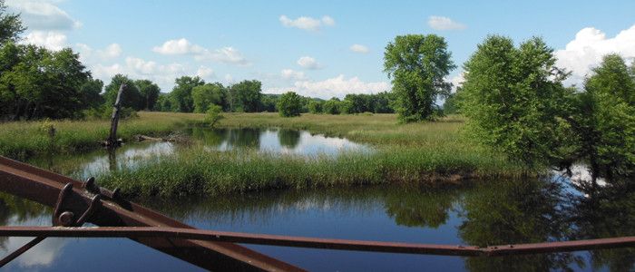
Habitat on the property consists primarily of floodplain forest, sand prairies and oak savanna. Situated on sand and gravel deposits of the Black River, it features groves of scattered oak forest with green ash. The sparse canopy of the savanna has permitted the development of prairie grasses and forbs and the exceptionally rich groundlayer has over 100 species documented. The mature floodplain forest situated between channels of the Black River contains canopy dominants of large silver maple, swamp white oak and green ash. Associated species include river birch, cottonwood, yellowbud hickory, American elm, basswood and black ash. Swamp white oak is reproducing well and there is good distribution of both size and age classes for most tree species, although very large individuals are relatively infrequent. The site is dissected by several flood channels and topography is nearly level. The shrub layer is moderately dense and composed of prickly ash, elderberry, buttonbush, common winterberry and nannyberry.
Van Loon is a WBCI Important Bird Area [exit DNR] noted for yellow-crowned night herons, Acadian flycatchers, cerulean warblers and prothonotary warblers that breed there. The site also supports red-headed woodpeckers, blue-winged warblers and field sparrows. Waterbirds congregate in late summer and thousands of landbirds migrate through, particularly in the spring. Van Loon is also featured in the Mississippi-Chippewa River Region of the Great Wisconsin Birding and Nature Trail [exit DNR]. The property also contains six historic McGilvray arch truss bridges [exit DNR] over the Black River built circa 1892. McGilvray Road is open to foot traffic and is a popular walking path for viewing the bridges, historic interpretation, wildlife watching, and nature enjoyment. There is one site available for primitive camping on a first-come-first-served basis in the northern part of the property.
Management Objectives
History
Van Loon Wildlife Area originated in 1948 as a lease project known then as McGilvray Bottoms. Fee acquisition began in 1957 with the purchase of 758 acres from the William Van Loon estate. Van Loon Wildlife Area contains six historic bridges over the Black River built along a former vehicular road, known as McGilvray Road, crossing 1.8 miles through the property. Dating from circa 1892, one is a low truss bridge and the other five are rare bowstring arch truss bridges. They represent two styles of bridge construction that were popular in the nineteenth and early twentieth centuries. Access to McGilvray Road is available off New Amsterdam Road on the east side of the wildlife area. McGilvray Road and the bridges are maintained by the Friends of McGilvray Road in cooperation with the department.
Management
The Black River (including Van Loon Wildlife Area) is identified as a Conservation Opportunity Area [PDF] for Large River Corridors of Continental Significance within the Western Coulee and Ridges Ecological Landscape according to Wisconsin's Wildlife Action Plan. The wildlife area is managed to provide opportunities for public hunting, fishing, trapping, and other outdoor recreation while protecting the qualities of the unique native communities and associated species found on the property. The state natural areas are primarily managed passively, with some thinning of the canopy, understory manipulation and shrub control via harvest, brushing or fire to mimic natural disturbance patterns in the savanna. Management efforts are designed to protect the ecological river corridor gradients from lowlands to uplands, along with the protection of the floodplain corridor. This will enlarge the amount of habitat available, allow for the movement of species upslope and downslope as environmental conditions change over time, provide migratory bird stopover habitat and provide suitable habitat for species that require large areas or are dependent upon a mosaic of interconnected habitats, including a full range of seral stages, for their long-term survival. Populations of invasive species are controlled or eliminated by cutting, pulling, burning, herbicide treatment and/or bio-control.
For more information on master planning for this and other wildlife areas around the state, visit the property planning page.
Recreation
The Van Loon Wildlife Area offers many recreational opportunities:
- Birding;
- Camping (primitive);
- Canoeing;
- Cross-country skiing (no designated trail);
- Fishing;
- Hiking (no designated trail);
- Hunting;
- Trapping;
- Wild edibles/gathering; and
- Wildlife viewing.
Amenities
- Bathroom? No.
- Parking Lot? Yes, multiple.
- Trails? Yes.
- Campground? One primitive campsite.
Maps
Download [PDF] a map of this property.
If you are interested in exploring this property further, you can access an interactive map.
There is one site available for primitive camping on a first-come-first-served basis in the northern part of the property. Boat access is available in the northern part of the wildlife area off USH 53/STH 93 and farther south where STH 35 crosses the property.
Directions:
- Highway 53 Landing
- Access to the northern portion of Van Loon WMA.
- Canoe or small motorboat launch.
- The closest parking lot to the canoe access campsite on the northern portion of the property.
- McGilvray "Seven Bridges" Road
- Trail head for McGilvray Road or “Seven Bridges”.
- McGilvray Road allows users to access 1.8 miles into the property on a well-maintained trail.
- Top-tier wildlife viewing and hiking option.
- Most used parking lot on the property during all seasons.
- Van Loon Wildlife Area South
- South access into the property.
- Users can access 1.5 miles into the property following our DNR management access road.
- Directly on the south side of Hwy 35 is a La Crosse County-owned and maintained boat landing (Public Boat Landing).
