Regional Haze
Haze and Visibility Protection
Haze is caused when tiny particles of air pollution scatter sunlight, which reduce the clarity and color of what we see. Air pollutants that contribute to fine particle formation and haze come from a variety of natural and man-made sources and can be transported hundreds of miles and across state lines. Haze degrades visibility in many American cities and scenic areas, especially during humid conditions.
The US Environmental Protection Agency's (EPA) Regional Haze Rule (or Haze Rule) calls for state and federal agencies to work together to improve visibility in 156 national parks and wilderness areas, including the Grand Canyon, Yosemite, the Great Smoky Mountains and Shenandoah. These parks and pristine areas are called Class I Areas.
The Haze Rule requires that states — in coordination with the EPA, Federal Land Managers (FLMs; National Park Service, U.S. Fish & Wildlife Service, and U.S. Forest Service), and other interested parties — develop and implement air quality protection plans to reduce the pollution that degrades visibility. The overall goal is to eliminate the manmade effects on visibility by 2064. The Haze Rule establishes implementation periods (or rounds) that act as interim milestones to ensure that states are on track to meet the 2064 goal.
Visit EPA's Regional Haze Program to learn more about the Haze Rule.
Regional Planning
Because regional haze can originate from sources located across large geographic areas, the EPA has encouraged states and tribes to address visibility degradation from a regional perspective. States and tribes coordinate under five regional air quality organizations.
Wisconsin addresses regional haze in collaboration with other Midwestern states as a member of the Lake Michigan Air Directors Consortium. The primary objective of LADCO's regional haze initiative is to assess both visibility impairment in the Class I areas located in Illinois, Indiana, Michigan, Minnesota, Ohio and Wisconsin, and the impact of emissions from these states on visibility impairment. Members of the initiative include the six states, tribes, the FLMs and the EPA.
For more information on the other four regional air quality organizations and their work on regional haze, visit the following websites:
- Southeastern States Air Resource Managers
- The Mid-Atlantic/Northeast Visibility Union
- Western Regional Air Partnership
- Central States Air Resource Agencies
Regional Haze - Round 1
Wisconsin's Round 1 Regional Haze State Implementation Plan (SIP)
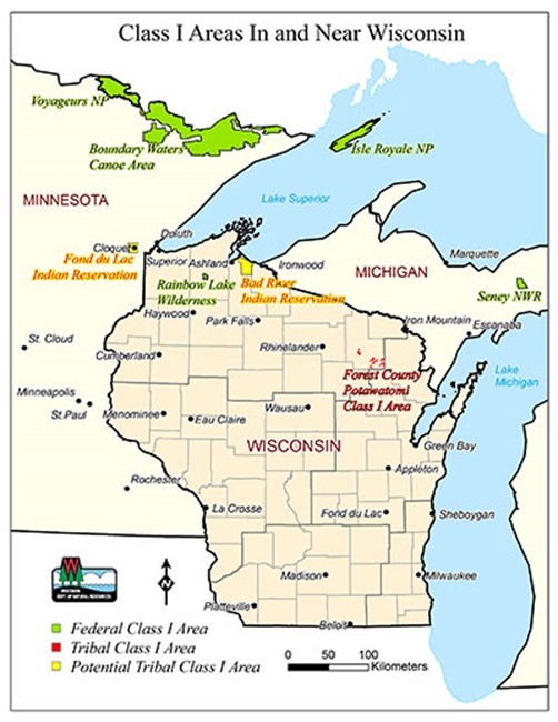
The first implementation period of the Haze Rule, “Round 1,” spans the years from 2008 to 2018. LADCO determined that Wisconsin's emission sources impact visibility in four Class I areas — Boundary Waters Canoe Area Wilderness, Voyageurs National Park, Isle Royale National Park and Seney National Wildlife Refuge. Under the Haze Rule, Wisconsin must submit a State Implementation Plan (SIP) to the EPA that demonstrates the state is on track to help meet reasonable progress goals for visibility improvement at the four areas. The SIP describes Wisconsin's strategy for meeting the progress goals by 2018 for these four areas, with the eventual goal of achieving pristine visibility conditions by 2064. This strategy takes advantage of emissions reductions from various control programs and includes submission of a plan for the application of Best Available Retrofit Technology (BART) for specific emission sources.
The DNR proposed Regional Haze SIP requirements in July 2011 for public comment. The DNR received comments from Georgia Pacific, U.S. Forest Service, National Parks Service and the EPA, and joint comments from Sierra Club and the Midwest Environment Defense Center. The DNR responded to these comments and amended the Wisconsin Regional Haze SIP accordingly.
The following documents support Wisconsin's Regional Haze SIP. The SIP is divided into three parts:
- Wisconsin Regional Haze SIP,
- Wisconsin's Implementation of BART, and
- Revisions to Wisconsin's State Implementation Plan for Protection of Visibility.
The public comments received on the July 2011 proposed Regional Haze SIP are also included below.
- Cover Letter — Regional Haze SIP
- Attachment 1 — EPA SIP checklist
- Attachment 2 — Regional Haze SIP Submittal
- Attachment 3 — Regional Air Quality Analyses for Ozone, PM2.5, and Regional Haze, April 25, 2008
- Attachment 4 — Proof of Public Hearing on Sept. 13, 2011 and Summary/Response to Public Comments
Wisconsin submitted its Round 1 regional haze SIP on January 18, 2012. The EPA approved it on August 7, 2012 (77 FR 46952).
Wisconsin's Implementation of BART
- Implementation of BART
- EPA SIP checklist
- Draft BART Technical Support Document for EGUs — Dated July 1, 2011
- Draft BART Technical Support Document for Non-EGUs — Dated July 1, 2011
- Final BART Determination and Summary of Changes from Draft Technical Support Documents
- BART Modeling for PCA-Tomahawk, Thilmany, and Wausau-Mosinee
- Draft Administrative Order (AO) for Georgia Pacific
* To be finalized after proposed approval by the EPA - Template for EGU BART Permit Revisions for Implementation of BART
* To be finalized in EGU-specific permits after proposed approval by the EPA - BART Analysis Submitted by Georgia Pacific
- Proof of Public Hearing on July 29, 2010 (Response to Public Comments Included in Attachment 3)
- Proof of Public Hearing on Sept. 13, 2011 and Summary/Response to Public Comments
Revisions to Wisconsin's State Implementation Plan for Protection of Visibility
- BART Rule
- EPA SIP checklist
- Chapter NR 433, Wis. Adm. Code, as amended
- Section NR 484 (11m), Wis. Adm. Code
- Proof of public hearing, including public hearing notice, for BART rules adoption. Copy of legal notice from Feb. 9, 2007, Wisconsin State Journal
- Background for AM-04-06 and public comments received for BART rules adoption — summary and response
- Proof of public hearing, including public hearing notice, for BART rules revision. Copy of legal notice from March 22, 2010, Wisconsin State Journal
- Background for AM-06-09 and public comments received for BART rules revision — summary and response
Comments Received on July 2011 Regional Haze SIP
- U.S. Forest Service
- National Park Service
- Georgia-Pacific
- Sierra Club and Midwest Environmental Defense Center
- U.S. Environmental Protection Agency
Improving Visibility
Other efforts underway to help improve visibility in Class I areas include Best Available Retrofit Technology (BART) requirements and regional haze consultation.
Best Available Retrofit Technology (BART)
Best Available Retrofit Technology affects certain large sources of NOx, SO2 or direct particle pollution. This technology relates only to sources that began operation between 1962 and 1977. The federal regional haze regulation requires that BART determination be based on an analysis of the best system of continuous emission control technology available, performed on a source-by-source basis taking into account the following criteria:
- the costs of compliance
- the energy and non-air quality environmental impacts of compliance
- any pollution control equipment in use at the source
- the remaining useful life of the source
Wisconsin's BART rule establishes a procedure for determining requirements to control SO2, NOx and particle pollution emissions from sources subject to BART, which are mainly boilers at electric generating power plants and at pulp and paper facilities. Note the electric generating power plants subject to BART do not need to install, operate and maintain BART for SO2 and NOx controls if they are subject to the SO2 and NOx trading programs that are part of the Clean Air Interstate Rule (CAIR).
Regional Haze Consultation - Northern Class I Areas
Michigan and Minnesota, along with representatives of other states (including Wisconsin), tribal governments, the FLMs and the EPA, are working to address visibility impairment due to regional haze in four northern Class I areas: Boundary Waters Canoe Area Wilderness, Voyageurs National Park, Isle Royale National Park and Seney National Wildlife Refuge.
To support consultation in the development of reasonable progress plans for the Northern Class I Areas, the interested parties created a technical document that addresses the causes of visibility degradation in the area. The key findings of the document are as follows:
- The chemical species that affect visibility impairment include ammonium sulfate and, to a lesser degree, ammonium nitrate and organic carbon.
- The pollutants and source sectors that contribute the most to visibility impairment include:
- SO2 emissions from power plants/electrical generating units (EGUs) and certain non-EGUs, which lead to sulfate formation;
- NOx emissions from a variety of sources such as motor vehicles, which lead to nitrate formation;
- ammonia emissions from livestock waste and fertilizer applications, which are also important, especially for nitrate formation; and
- organic carbon concentrations, which are thought to be mostly secondary organic aerosols of biogenic origin and, on an occasional episodic basis, from fire activity.
- The source states that contribute the most to visibility impairment are Michigan, Minnesota and Wisconsin. Other nearby states also contribute to visibility impairment.
- Current visibility levels are well above natural conditions.
For more information, review LADCO's Regional Haze in the Upper Midwest: Summary of Technical Information.
Minnesota "Ask"
Through the regional consultation process, the Minnesota Pollution Control Agency (MPCA) determined that Wisconsin significantly contributes to visibility impairment at Boundary Waters Canoe Area Wilderness and Voyageurs National Park. The MPCA asked the states that contribute to visibility impairment at those sites to consider the following control programs when developing their visibility plans.
- Implementation of BART
- Matching statewide average emission rate for power plants to Minnesota's voluntary emission rates
- NOx - 0.25 lbs/mmBtu
- SO2 - 0.25 lbs/mmBtu
- Continued assessment of reasonable measures for industrial/commercial/institutional boilers, reciprocating engines and turbines
For more information, see Minnesota's regional haze plan.
Vermont "Ask"
Through the regional consultation process with the Mid-Atlantic/Northeast Visibility Union (MANE-VU), Vermont determined that Wisconsin significantly contributes to visibility impairment at Lye Brook Wilderness. Vermont asked the states that contribute to visibility impairment at Lye Brook to consider the following control programs when developing their visibility plans.
- Implementation of BART
- 90% SO2 reduction at selected power plants.
- Pleasant Prairie is the only identified power plant in Wisconsin and has installed scrubbers to meet the 90% goal.
- 28% SO2 reduction from non-power plant sources
- The 28% reduction is relative to 2018 on-the-books emission projections.
For more information on Vermont's regional haze plan, review the Vermont regional haze plan.
Wisconsin's Regional Haze Progress Report
The federal Regional Haze Rule requires states to submit progress reports five years after they submit their initial regional haze SIPs. The progress report serves as an assessment of whether a state's regional haze SIP is being implemented appropriately and whether reasonable visibility improvement is being achieved. Wisconsin's five-year progress report shows that pollutant emissions from Wisconsin sources decreased and visibility conditions at Minnesota and Michigan Class I areas improved over the five-year period as expected. These considerations, in part, helped the DNR determine that Wisconsin's regional haze SIP continued to support visibility improvement at nearby Class I areas. The EPA approved Wisconsin's five-year progress report in December 2017.
Regional Haze - Round 2
Round 2 of the Regional Haze Program
The Haze Rule requires states to re-assess and revise their incremental regional haze State Implementation Plan (SIP) every 10 years to continue meeting reasonable progress goals for natural visibility conditions at Class I areas by 2064. The Haze Rule, originally adopted on July 1, 1999, was revised effective January 10, 2017 (82 FR 3078). Under the original rule, regional haze SIP revisions covering the second implementation period (Round 2) from 2018 through 2028 was due July 31, 2018; however, the U.S. Environmental Protection Agency (EPA) extended the deadline to July 31, 2021, in the 2017 amendments to the Regional Haze Rule.
Development of Wisconsin's Round 2 Regional Haze SIP
Wisconsin addresses regional haze in collaboration with other Midwestern states as a member of the Lake Michigan Air Directors Consortium (LADCO). The primary objective of LADCO's regional haze initiative is to assess both visibility impairment in the Class I areas located in Illinois, Indiana, Michigan, Minnesota, Ohio and Wisconsin, and the impact of emissions from these states on visibility impairment. For the Round 2 period, it was determined that emission sources in Wisconsin impact visibility at four nearby Class I areas:
- Isle Royale National Park (Michigan)
- Seney Wilderness Area (Michigan)
- Boundary Waters Canoe Area (Minnesota)
- Voyageurs National Park (Minnesota)
Under the Haze Rule, a state contributing to visibility impairment of a Class I area in another state is required to consult with the affected state to develop coordinated emission management strategies containing the emission reductions necessary to make reasonable progress (40 CFR § 51.308(f)(2)(ii)). Wisconsin worked with Michigan, Minnesota and other LADCO states to develop a long-term strategy to ensure continued improvements in visibility conditions at the Class I areas that Wisconsin impacts. States must also engage the FLMs and consider their input when developing their proposed regional haze SIP revisions (40 CFR § 51.308(i)).
Federal Land Manager Comments Received on February 2021 - Preliminary Draft of Wisconsin's Round 2 Regional Haze SIP
Wisconsin shared its preliminary draft Round 2 haze SIP with FLMs on February 22, 2021, initiating a 60-day mandatory FLM review period (40 CFR § 51.308(i)(2)). The DNR received the following comments during the 60-day FLM review period.
Wisconsin's Round 2 Regional Haze SIP
Wisconsin submitted its Round 2 haze SIP for the second planning period from 2018-2028 on July 30, 2021.