Tunnel Channel Woods
No. 592
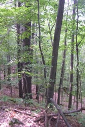 Photo by DNR
The rolling glacial terrain of Tunnel Channel Woods supports an extensive, second-growth dry-mesic forest with scattered ephemeral ponds and kettle wetlands. The dominant trees include red oak, white oak, basswood, and red maple. Canopy associates are green ash, bur oak, paper birch, and aspen. White pine, yellow birch, shagbark hickory, and yellowbud hickory are also present. The shrub layer is variable in density with hazelnut, alternate-leaved dogwood, and maple-leaf viburnum. Characteristic ground layer species include wild sarsaparilla, big-leaf aster, lady fern, wild geranium, large-flowered bellwort, enchanter's nightshade, pointed tick-trefoil, American lopseed, and white avens.
More northern ground layer species are found scattered throughout the forest and represented by partridgeberry, yellow blue bead lily, early low blueberry, and American starflower. Inclusions of more mesic forests with yellow birch, maidenhair fern, and false rue anemone are also present and small ponds and pockets of wet swamp hardwoods also occur. The forest supports numerous rare species, including several Species of Greatest Conservation Need. Two state-threatened bird species are also found here. In 2006, one was found to occur in very high densities, which is unusual anywhere in the state but particularly at a site this far north. More common bird species usually associated with "southern "habitats include yellow-throated vireo, wood thrush, and blue-gray gnatcatcher. Other breeding birds include pileated woodpecker, hermit thrush, chestnut-sided warbler, black and white warbler, ovenbird, indigo bunting, and rose-breasted grosbeak. Trumpeter swans have also been observed using Straight Lake during the breeding season. Tunnel Channel Woods is owned by the DNR and was designated a State Natural Area in 2009.
Very few State Natural Areas have public facilities, but nearly all are open for a variety of recreational activities as indicated below. Generally, there are no picnic areas, restrooms, or other developments. Parking lots or designated parking areas are noted on individual SNA pages and maps. If a developed trail is present, it will normally be noted on the SNA map and/or under the Maps tab. A compass and topographic map or a GPS unit are useful tools for exploring larger, isolated SNAs.
The good majority of SNAs are isolated and have few or no facilities. Some SNAs have vehicle access lanes or parking lots, but their accessibility may vary depending on weather conditions. Parking lots and lanes are not plowed during winter. Hiking trails may be nonexistent or consist of undeveloped footpaths. A GPS unit or compass and a detailed topographic map are useful tools for exploring larger SNAs.
Entrance fees: Except for Parfrey's Glen, the Cambrian Outlook in the Dells of the Wisconsin River, SNAs within State Parks and some within State Forests, all other DNR-owned SNAs do not have any admission fees. For more information, see Wis. Admin. Code NR 45 [exit DNR]. For non-DNR-owned SNAs, we are unaware of any vehicle or admission fees. However, please contact the landowner for more information.
Allowable activities: DNR-owned land
The activities listed below are generally allowed on all DNR-owned SNA lands. Exceptions to this list of public uses, such as SNAs closed to hunting, are noted above and posted with signs on the property site.
- Hiking
- Fishing
- Cross country skiing
- Hunting
- Trapping
- Scientific research (permit required [PDF])
- Outdoor education
- Wild edibles (What is this?)
- Pets (Rules)
- Wildlife viewing
Prohibited activities: all SNAs
Although a handful of sites allow activities like primitive camping (e.g. Lower Chippewa River on sand bars) or horseback riding (e.g. S. Kettle Moraine), the activities listed below are generally prohibited on DNR-owned SNAs.
- Camping and campfires
- Collecting of animals (other than legally harvested species), non-edible fungi, rocks, minerals, fossils, archaeological artifacts, soil, downed wood, or any other natural material, alive or dead.
- Collecting for scientific research requires a permit issued by the DNR
- Collecting of plants including seeds, roots or other non-edible parts of herbaceous plants such as wildflowers or grasses
- Drones: Flying-related activities, including the use of drones, hang-gliders and model airplanes, are prohibited. Permission may be issued by the SNA Program for the use of drones for educational or research purposes
- Geocaching
- Horseback riding
- Rock climbing
- Vehicles, including bicycles, ATVs, aircraft, and snowmobiles except on trails and roadways designated for their use.
For rules governing state-owned SNAs and other state lands, please consult Chapter NR 45 Wis. Admin. Code [exit DNR].
Location
Within Straight Lake State Park and Wildlife Area, Polk County. T36N-R16W, Sections 17, 18. T36N-R17W, Section 13. 457 acres.
Driving directions
From the intersection of Highway 35 and 48 in Luck, go east for 48 5 miles, then north on 100th Street 2 miles to an old can pull off-off west of the road.
The DNR's state natural areas program is comprised of lands owned by the state, private conservation organizations, municipalities, other governmental agencies, educational institutions and private individuals. While the majority of SNAs are open to the public, access may vary according to individual ownership policies. Public use restrictions may apply due to public safety, or to protect endangered or threatened species or unique natural features. Lands may be temporarily closed due to specific management activities. Users are encouraged to contact the landowner for more specific details.
The data shown on these maps have been obtained from various sources, and are of varying age, reliability, and resolution. The data may contain errors or omissions and should not be interpreted as a legal representation of legal ownership boundaries.
To create your custom map where you can zoom to a specific location, please use the DNR's mapping application.
Tunnel Channel Woods is owned by: Wisconsin DNR