South Bluff/Devil's Nose
No. 97
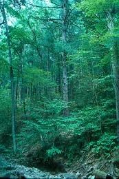
Photo by Thomas A. Meyer/DNR
South Bluff/Devil's Nose encompasses a huge expanse of the forested southern flank of the Baraboo Hills and provides a habitat for numerous rare plants and animals. The majority of the site is a southern mesic and dry-mesic forest of sugar maple, red oak, white oak, basswood, and hickory. Within the site is Pine Glen, a deep spectacular gorge cut into the Baraboo quartzite. On its south slope is a small cedar glade and dry prairie that have unusual floras. Cold air drainage at the lower end of Pine Glen harbors northern plant species such as white pine, oak fern, yellow blue-bead-lily, and rosy twisted stalk that thrive in the cool ravine.
Also in the area is spring-fed Messenger Creek, which occupies an ancient valley, cut into the Precambrian Baraboo quartzite. The rich wooded area contains yellow birch, eastern hop-hornbeam, and ironwood and is rich in mosses and uncommon ferns. One of the primary features of the natural area is the presence of several uncommon to rare plant species of sedges and orchids. The site also harbors many rare warblers and forest-interior birds. South Bluff/Devil's Nose is owned by the DNR and was designated a State Natural Area in 1972.
Very few State Natural Areas have public facilities, but nearly all are open for a variety of recreational activities as indicated below. Generally, there are no picnic areas, restrooms, or other developments. Parking lots or designated parking areas are noted on individual SNA pages and maps. If a developed trail is present, it will normally be noted on the SNA map and/or under the Maps tab. A compass and topographic map or a GPS unit are useful tools for exploring larger, isolated SNAs.
The good majority of SNAs are isolated and have few or no facilities. Some SNAs have vehicle access lanes or parking lots, but their accessibility may vary depending on weather conditions. Parking lots and lanes are not plowed during winter. Hiking trails may be nonexistent or consist of undeveloped footpaths. A GPS unit or compass and a detailed topographic map are useful tools for exploring larger SNAs.
Entrance fees: Except for Parfrey's Glen, the Cambrian Outlook in the Dells of the Wisconsin River, SNAs within State Parks and some within State Forests, all other DNR-owned SNAs do not have any admission fees. For more information, see Wis. Admin. Code NR 45 [exit DNR]. For non-DNR-owned SNAs, we are unaware of any vehicle or admission fees. However, please contact the landowner for more information.
Allowable activities: DNR-owned land
The activities listed below are generally allowed on all DNR-owned SNA lands. Exceptions to this list of public uses, such as SNAs closed to hunting, are noted above and posted with signs on the property site.
- Hiking
- Fishing
- Cross country skiing
- Hunting
- Trapping
- Scientific research (permit required [PDF])
- Outdoor education
- Wild edibles (What is this?)
- Pets (Rules)
- Wildlife viewing
Prohibited activities: all SNAs
Although a handful of sites allow activities like primitive camping (e.g. Lower Chippewa River on sand bars) or horseback riding (e.g. S. Kettle Moraine), the activities listed below are generally prohibited on DNR-owned SNAs.
- Camping and campfires
- Collecting of animals (other than legally harvested species), non-edible fungi, rocks, minerals, fossils, archaeological artifacts, soil, downed wood, or any other natural material, alive or dead.
- Collecting for scientific research requires a permit issued by the DNR
- Collecting of plants including seeds, roots or other non-edible parts of herbaceous plants such as wildflowers or grasses
- Drones: Flying-related activities, including the use of drones, hang-gliders and model airplanes, are prohibited. Permission may be issued by the SNA Program for the use of drones for educational or research purposes
- Geocaching
- Horseback riding
- Rock climbing
- Vehicles, including bicycles, ATVs, aircraft, and snowmobiles except on trails and roadways designated for their use.
For rules governing state-owned SNAs and other state lands, please consult Chapter NR 45 Wis. Admin. Code [exit DNR].
Location
Within Devil's Lake State Park, Sauk County. T11N-R6E, Sections 23-27, 34, 35, 36. T11N-R7E, Sections 29, 30, 31. 3,492 acres.
Driving directions
From the intersection of US Highway 12 and State Highway 136 in West Baraboo, go east (south) for 12 3.8 miles, then east on Ski Hifor Road for 1.2 miles, then south (right) on South Shorefor Road for 0.2 miles, then south on Burma Road 1.5 miles to its end. Or from the intersection of Burma and South Shore Road, continue on South Shore Road 0.6 miles to a parking area south of the road. Walk west along Messenger Creek into the site.
The DNR's state natural areas program is comprised of lands owned by the state, private conservation organizations, municipalities, other governmental agencies, educational institutions, and private individuals. While the majority of SNAs are open to the public, access may vary according to individual ownership policies. Public use restrictions may apply due to public safety, or to protect endangered or threatened species or unique natural features. Lands may be temporarily closed due to specific management activities.
Users are encouraged to contact the landowner for more specific details. The data shown on these maps have been obtained from various sources, and are of varying age, reliability, and resolution. The data may contain errors or omissions and should not be interpreted as a legal representation of legal ownership boundaries. To create your custom map where you can zoom to a specific location, please use the DNR's Mapping Application.
South Bluff/Devil's Nose is owned by: Wisconsin DNR