Mirror Lake Pine Oak Forest
No. 406
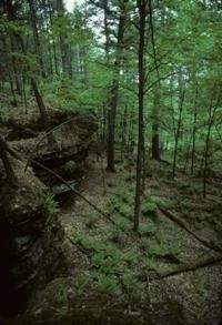
Photo by Thomas A. Meyer/DNR
Mirror Lake Pine Oak Forest features a mature dry-mesic forest dominated by white pine and oaks, with dry sandstone cliffs, alder thicket, and scattered vernal ponds. The gently undulating sandy uplands west of Mirror Lake support the forest, which is dominated by white pine, white oak, red oak, and black oak. Red pine is co-dominant above the sandstone cliffs flanking the lake and is locally present elsewhere. The sapling layer is composed primarily of white pine, red maple, and a few scattered white oaks.
Huckleberry dominates the shrub layer with American hazelnut occurring at various locations. Other characteristic low shrubs and herbs include early low blueberry, swamp dewberry, pipsissewa, creeping snowberry, wintergreen, princess'-pine, spinulose wood fern, narrow-leaved loosestrife, sessile-leaved bellwort, long-awned wood grass, and maidenhair fern. Locally, there are pockets of moister, somewhat richer forests in which red maple is an important component of the forest. The ground layer contains an enchanter's nightshade, wild sarsaparilla, and Jack-in-the-pulpit. An extensive shrub swamp dominated by speckled alder borders a small perennial tributary of Dell Creek.
Characteristic flora includes skunk cabbage, marsh marigold, orange jewelweed, blue marsh violet, American golden saxifrage, and rough bedstraw. Also present is the rare plant. Numerous seepages occur along the tiny, clear, sandy-bottomed stream. Several short, cliff-enclosed dry ravines open to Mirror Lake with vertical rock exposures of nearly 12 meters in height. Nearer to Mirror Lake, red pine becomes more important as a canopy species. Bird life includes ruffed grouse, American woodcock, gray catbird, pileated woodpecker, barred owl, tufted titmouse, pine warbler, brown creeper and a state-threatened species. Mirror Lake Pine Oak Forest is owned by the DNR and was designated a State Natural Area in 2003.
Very few State Natural Areas have public facilities, but nearly all are open for a variety of recreational activities as indicated below. Generally, there are no picnic areas, restrooms, or other developments. Parking lots or designated parking areas are noted on individual SNA pages and maps. Trails, if present, are typically undesignated footpaths. If a developed trail is present, it will normally be noted on the SNA map. A compass and topographic map or a GPS unit are useful tools for exploring larger, isolated SNAs.
The good majority of SNAs are isolated and have few or no facilities. Some SNAs have vehicle access lanes or parking lots, but their accessibility may vary depending on weather conditions. Parking lots and lanes are not plowed during winter. Hiking trails may be nonexistent or consist of undeveloped footpaths. A GPS unit or compass and a detailed topographic map are useful tools for exploring larger SNAs.
Entrance fees: Except for Parfrey's Glen, the Cambrian Outlook in the Dells of the Wisconsin River, SNAs within State Parks and some within State Forests, all other DNR-owned SNAs do not have any admission fees.
Allowable activities: DNR-owned land
In general, the activities listed below are allowed on all DNR-owned SNA lands. Exceptions to this list of public uses, such as SNAs closed to hunting, are noted below and posted with signs on the property site.
- Hiking
- Fishing
- Cross country skiing
- Hunting
- Trapping
- Scientific research (permit required [PDF])
- Outdoor education
- Wild edibles (What is this?)
- Pets (Rules)
- Wildlife viewing
Prohibited activities: all SNAs
- Camping and campfires
- Collecting of animals (other than legally harvested species), non-edible fungi, rocks, minerals, fossils, archaeological artifacts, soil, downed wood, or any other natural material, alive or dead.
- Collecting for scientific research requires a permit issued by the DNR
- Collecting of plants including seeds, roots or other non-edible parts of herbaceous plants such as wildflowers or grasses
- Geocaching
- Horseback riding
- Rock climbing
- Vehicles, including bicycles, ATVs, aircraft, and snowmobiles except on trails and roadways designated for their use.
For rules governing state-owned SNAs and other state lands, please consult Chapter NR 45 Wis. Admin. Code [exit DNR].
Location
Within Mirror Lake State Park, Sauk County. T13N-R6E, Sections 29, 30, 31.
Driving directions
From the intersection of I-90/94 and State Highway 12 in Wisconsin Dells, go west on 12 0.5 miles, then west on Fern Dell Road 1.5 miles to the park entrance. Get a park map at the contact station. The natural area is situated in the northwest corner of the park.
The DNR's state natural areas program is comprised of lands owned by the state, private conservation organizations, municipalities, other governmental agencies, educational institutions and private individuals. While the majority of SNAs are open to the public, access may vary according to individual ownership policies. Public use restrictions may apply due to public safety, or to protect endangered or threatened species or unique natural features. Lands may be temporarily closed due to specific management activities.
Users are encouraged to contact the landowner for more specific details. The data shown on these maps have been obtained from various sources, and are of varying age, reliability, and resolution. The data may contain errors or omissions and should not be interpreted as a legal representation of legal ownership boundaries. To create your custom map where you can zoom to a specific location, please use the DNR's Mapping Application.
Mirror Lake Pine Oak Forest is owned by: Wisconsin DNR