Kinnickinnic River Gorge and Delta
No. 162
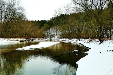
Photo by Aaron Carlson
Kinnickinnic River Gorge and Delta contains an undisturbed river gorge with a diversity of plant communities and features one of the finest examples of a river delta in Wisconsin. The deep river valley cut into a glacial drift, sandstone, and limestone, contains dry-mesic forest on the sheltered north-facing slope and xeric oak-cedar woods and small prairie openings on the exposed south-facing slope. The steep south bank contains large beds of Canada yew and walking fern under a forest of sugar maple, ironwood, and white pine.
The steep, thin-soiled slope contains hepatica, common polypody fern, walking fern and other mesic woodland plants. Dripping to dry cliffs is found intermittently throughout the valley. On the south side of the river is the Devil's Mixing Bowl - a series of cascades originating in a deep box canyon and emptying into a small pool. A spectacular example of dripping cliffs is found within this canyon. At the head of the canyon the sheer walls support a ribbon of bulblet ferns growing along a high shelf. From this shelf, waterfalls 10 feet to the canyon floor and down the cascades. The lower waterfall is dry except in wet seasons. Numerous mosses and lichens blanket the canyon floor. Of special geomorphologic interest is the large semi-open delta deposited by the Kinnickinnic River as it flows into the St. Croix River. The delta and river lowlands are used by waterfowl. Kinnickinnic River Gorge and Delta is owned by the DNR and was designated a State Natural Area in 1980.
Very few State Natural Areas have public facilities, but nearly all are open for a variety of recreational activities as indicated below. Generally, there are no picnic areas, restrooms, or other developments. Parking lots or designated parking areas are noted on individual SNA pages and maps. If a developed trail is present, it will normally be noted on the SNA map and/or under the Maps tab. A compass and topographic map or a GPS unit are useful tools for exploring larger, isolated SNAs.
The good majority of SNAs are isolated and have few or no facilities. Some SNAs have vehicle access lanes or parking lots, but their accessibility may vary depending on weather conditions. Parking lots and lanes are not plowed during winter. Hiking trails may be nonexistent or consist of undeveloped footpaths. A GPS unit or compass and a detailed topographic map are useful tools for exploring larger SNAs.
Entrance fees: Except for Parfrey's Glen, the Cambrian Outlook in the Dells of the Wisconsin River, SNAs within State Parks and some within State Forests, all other DNR-owned SNAs do not have any admission fees. For more information, see Wis. Admin. Code NR 45 [exit DNR]. For non-DNR-owned SNAs, we are unaware of any vehicle or admission fees. However, please contact the landowner for more information.
Allowable activities: DNR-owned land
The activities listed below are generally allowed on all DNR-owned SNA lands. Exceptions to this list of public uses, such as SNAs closed to hunting, are noted above and posted with signs on the property site.
- Hiking
- Fishing
- Cross country skiing
- Hunting
- Trapping
- Scientific research (permit required [PDF])
- Outdoor education
- Wild edibles (What is this?)
- Pets (Rules)
- Wildlife viewing
Prohibited activities: all SNAs
Although a handful of sites allow activities like primitive camping (e.g. Lower Chippewa River on sand bars) or horseback riding (e.g. S. Kettle Moraine), the activities listed below are generally prohibited on DNR-owned SNAs.
- Camping and campfires
- Collecting of animals (other than legally harvested species), non-edible fungi, rocks, minerals, fossils, archaeological artifacts, soil, downed wood, or any other natural material, alive or dead.
- Collecting for scientific research requires a permit issued by the DNR
- Collecting of plants including seeds, roots or other non-edible parts of herbaceous plants such as wildflowers or grasses
- Drones: Flying-related activities, including the use of drones, hang-gliders and model airplanes, are prohibited. Permission may be issued by the SNA Program for the use of drones for educational or research purposes
- Geocaching
- Horseback riding
- Rock climbing
- Vehicles, including bicycles, ATVs, aircraft, and snowmobiles except on trails and roadways designated for their use.
For rules governing state-owned SNAs and other state lands, please consult Chapter NR 45 Wis. Admin. Code [exit DNR].
Location
Within Kinnickinnic State Park, Pierce County. T27N-R20W, Sections 13, 14. 88 acres.
Driving directions
From the intersection of State Hwy. 29 and County Hwy. FF just south of River Falls, go west on County Hwy. FF 5.5 miles, then north on County Hwy. F slightly less than 1 mile, then west on Cedar View Road 1 mile to the park entrance. Get a park map. Hike south into the area. A STATE PARK STICKER IS REQUIRED.
The DNR's state natural areas program is comprised of lands owned by the state, private conservation organizations, municipalities, other governmental agencies, educational institutions and private individuals. While the majority of SNAs are open to the public, access may vary according to individual ownership policies. Public use restrictions may apply due to public safety, or to protect endangered or threatened species or unique natural features. Lands may be temporarily closed due to specific management activities.
Users are encouraged to contact the landowner for more specific details. The data shown on these maps have been obtained from various sources, and are of varying age, reliability, and resolution. The data may contain errors or omissions and should not be interpreted as a legal representation of legal ownership boundaries. To create your custom map where you can zoom to a specific location, please use the DNR's Mapping Application.
Kinnickinnic River Gorge And Delta is owned by: Wisconsin DNR