Europe Bay Woods
No. 379
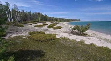
Photo by Thomas A. Meyer/DNR
Europe Bay Woods is located on an undeveloped isthmus between Lake Michigan and Europe Lake featuring over one mile of the Great Lakes dune and beach communities, red pine groves, boreal forest, and northern dry-mesic and mesic forest. The isthmus, once the ancient shoreline of Lake Michigan, was created through wave action resulting in sand and gravel deposition and today contains a northern dry-mesic forest dominated by red pine and red oak with scattered hemlock, beech, and red maple.
Common understory plants include beaked hazelnut, wild sarsaparilla, wintergreen, Canada mayflower, and rough-leaved rice grass. Also present is a mature mesic forest consisting of beech, sugar maple, red oak, and yellow birch on undulating topography. Along Lake Michigan, there is an undeveloped sand beach and low dunes grading to cobblestone beach and finally dolomite bedrock. The dunes contain extensive mats of bearberry and creeping juniper intermingled with rabbit-berry, and sand cherry. The area harbors numerous rare plants and animals. On gently sloping sandy soils are a boreal forest of balsam fir, white cedar, quaking aspen, white birch, and white spruce with white and red pine as the site grades into a forested ridge and swale community. Europe Bay Woods is owned by the DNR and was designated a State Natural Area in 2002.
Very few State Natural Areas have public facilities, but nearly all are open for a variety of recreational activities as indicated below. Generally, there are no picnic areas, restrooms, or other developments. Parking lots or designated parking areas are noted on individual SNA pages and maps. If a developed trail is present, it will normally be noted on the SNA map and/or under the Maps tab. A compass and topographic map or a GPS unit are useful tools for exploring larger, isolated SNAs.
The good majority of SNAs are isolated and have few or no facilities. Some SNAs have vehicle access lanes or parking lots, but their accessibility may vary depending on weather conditions. Parking lots and lanes are not plowed during winter. Hiking trails may be nonexistent or consist of undeveloped footpaths. A GPS unit or compass and a detailed topographic map are useful tools for exploring larger SNAs.
Entrance fees: Except for Parfrey's Glen, the Cambrian Outlook in the Dells of the Wisconsin River, SNAs within State Parks and some within State Forests, all other DNR-owned SNAs do not have any admission fees. For more information, see Wis. Admin. Code NR 45 [exit DNR]. For non-DNR-owned SNAs, we are unaware of any vehicle or admission fees. However, please contact the landowner for more information.
Allowable activities: DNR-owned land
The activities listed below are generally allowed on all DNR-owned SNA lands. Exceptions to this list of public uses, such as SNAs closed to hunting, are noted above and posted with signs on the property site.
- Hiking
- Fishing
- Cross country skiing
- Hunting
- Trapping
- Scientific research (permit required [PDF])
- Outdoor education
- Wild edibles (What is this?)
- Pets (Rules)
- Wildlife viewing
Prohibited activities: all SNAs
Although a handful of sites allow activities like primitive camping (e.g. Lower Chippewa River on sand bars) or horseback riding (e.g. S. Kettle Moraine), the activities listed below are generally prohibited on DNR-owned SNAs.
- Camping and campfires
- Collecting of animals (other than legally harvested species), non-edible fungi, rocks, minerals, fossils, archaeological artifacts, soil, downed wood, or any other natural material, alive or dead.
- Collecting for scientific research requires a permit issued by the DNR
- Collecting of plants including seeds, roots or other non-edible parts of herbaceous plants such as wildflowers or grasses
- Drones: Flying-related activities, including the use of drones, hang-gliders and model airplanes, are prohibited. Permission may be issued by the SNA Program for the use of drones for educational or research purposes
- Geocaching
- Horseback riding
- Rock climbing
- Vehicles, including bicycles, ATVs, aircraft, and snowmobiles except on trails and roadways designated for their use.
For rules governing state-owned SNAs and other state lands, please consult Chapter NR 45 Wis. Admin. Code [exit DNR].
Location
Within Newport State Park, Door County. T32N-R29E, Sections 8, 9, 16, 17. 442 acres.
Driving directions
From Ellison Bay, go east on State Highway 42 about 2.3 miles to the broad curve to the north, then continue east on Europe Bay Road about 2 miles to town park along Lake Michigan. The natural area lies north of the road between Lake Michigan and Europe Lake and is accessible via the Hotz and Europe Bay hiking trails. A Wisconsin State Park sticker must be displayed on all vehicles entering the state park.
The DNR's state natural areas program is comprised of lands owned by the state, private conservation organizations, municipalities, other governmental agencies, educational institutions and private individuals. While the majority of SNAs are open to the public, access may vary according to individual ownership policies. Public use restrictions may apply due to public safety, or to protect endangered or threatened species or unique natural features. Lands may be temporarily closed due to specific management activities.
Users are encouraged to contact the landowner for more specific details. The data shown on these maps have been obtained from various sources, and are of varying age, reliability, and resolution. The data may contain errors or omissions and should not be interpreted as a legal representation of legal ownership boundaries. To create your custom map where you can zoom to a specific location, please use the DNR's Mapping Application.
Europe Bay Woods is owned by: Wisconsin DNR