East Bluff
No. 98
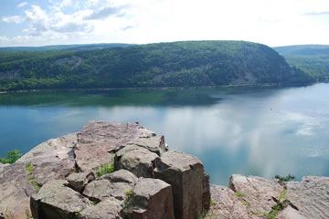
Photo by Josh Mayer
East Bluff is a continuum of natural communities of great ecological interest grading from open talus slopes, to dry prairie and glade, to open oak woodland, and finally a closed canopy southern hardwood forest. A moist, shaded grotto is also present downslope. Deposited by glacial action, the extensive 400-foot high talus slope is composed of angular blocks of quartzite below the vertical cliffs. Perched atop the quartzite talus is a curious open woodland - a pygmy forest of stunted shagbark hickory and white ash. And along the bluff edge are among the best examples of dry prairie and bedrock glade within Wisconsin. Trees average only 4 to 6 inches in diameter and 20-30 feet in height.
The ground layer is dominated by Pennsylvania sedges with other grasses including poverty oat grass, little blue-stem, and big blue-stem. Other herbaceous plants are columbine, shooting star, prairie coreopsis, prairie alumroot, field pussy-toes, and large-flowered yellow false foxglove. In some areas, quartzite is exposed at the surface and contains a distinctive lichen and moss flora. The southern dry forest is dominated by white and red oaks with black cherry, shagbark hickory, big-tooth aspen, red maple, and white pine. The ground layer contains species such as black-seeded rice grass, arrow-leaved aster, marginal wood fern, shining bedstraw, round-lobed hepatica, hairy sweet cicely, and false Solomon's-seal. The Alaskan Grotto is a unique linear geological feature along the south base of East Bluff, which supports a particularly diverse assemblage of plant species characteristic of northern Wisconsin forests. East Bluff harbors several rare plants. East Bluff is owned by the DNR and was designated a State Natural Area in 1993.
Very few State Natural Areas have public facilities, but nearly all are open for a variety of recreational activities as indicated below. Generally, there are no picnic areas, restrooms, or other developments. Parking lots or designated parking areas are noted on individual SNA pages and maps. If a developed trail is present, it will normally be noted on the SNA map and/or under the Maps tab. A compass and topographic map or a GPS unit are useful tools for exploring larger, isolated SNAs.
The good majority of SNAs are isolated and have few or no facilities. Some SNAs have vehicle access lanes or parking lots, but their accessibility may vary depending on weather conditions. Parking lots and lanes are not plowed during winter. Hiking trails may be nonexistent or consist of undeveloped footpaths. A GPS unit or compass and a detailed topographic map are useful tools for exploring larger SNAs.
Entrance fees: Except for Parfrey's Glen, the Cambrian Outlook in the Dells of the Wisconsin River, SNAs within State Parks and some within State Forests, all other DNR-owned SNAs do not have any admission fees. For more information, see Wis. Admin. Code NR 45 [exit DNR]. For non-DNR-owned SNAs, we are unaware of any vehicle or admission fees. However, please contact the landowner for more information.
Allowable activities: DNR-owned land
The activities listed below are generally allowed on all DNR-owned SNA lands. Exceptions to this list of public uses, such as SNAs closed to hunting, are noted above and posted with signs on the property site.
- Hiking
- Fishing
- Cross country skiing
- Hunting
- Trapping
- Scientific research (permit required [PDF])
- Outdoor education
- Wild edibles (What is this?)
- Pets (Rules)
- Wildlife viewing
Prohibited activities: all SNAs
Although a handful of sites allow activities like primitive camping (e.g. Lower Chippewa River on sand bars) or horseback riding (e.g. S. Kettle Moraine), the activities listed below are generally prohibited on DNR-owned SNAs.
- Camping and campfires
- Collecting of animals (other than legally harvested species), non-edible fungi, rocks, minerals, fossils, archaeological artifacts, soil, downed wood, or any other natural material, alive or dead.
- Collecting for scientific research requires a permit issued by the DNR
- Collecting of plants including seeds, roots or other non-edible parts of herbaceous plants such as wildflowers or grasses
- Drones: Flying-related activities, including the use of drones, hang-gliders and model airplanes, are prohibited. Permission may be issued by the SNA Program for the use of drones for educational or research purposes
- Geocaching
- Horseback riding
- Rock climbing
- Vehicles, including bicycles, ATVs, aircraft, and snowmobiles except on trails and roadways designated for their use.
For rules governing state-owned SNAs and other state lands, please consult Chapter NR 45 Wis. Admin. Code [exit DNR].
Location
Within Devil's Lake State Park, Sauk County. T11N-R7E, Section 19. T11N-R6E, Section 24. 254 acres.
Driving directions
From the intersection of US Highway 12 and State Highway 136 in West Baraboo, go east (south) on 12 for 3.8 miles, then east on Ski Hi Road for 1.2 miles, then south (right) on South Shore Road to the South Shore main gate for and parking/campground area. The Grottos, East Bluff, and East Bluff Woods Trails provide access to the site.
The DNR's state natural areas program comprises lands owned by the state, private conservation organizations, municipalities, other governmental agencies, educational institutions and private individuals. While the majority of SNAs are open to the public, access may vary according to individual ownership policies. Public use restrictions may apply due to public safety, or to protect endangered or threatened species or unique natural features. Lands may be temporarily closed due to specific management activities.
Users are encouraged to contact the landowner for more specific details. The data shown on these maps have been obtained from various sources, and are of varying age, reliability, and resolution. The data may contain errors or omissions and should not be interpreted as a legal representation of legal ownership boundaries. To create your custom map where you can zoom to a specific location, please use the DNR's Mapping Application.
East Bluff is owned by: Wisconsin DNR