Devil's Lake Oak Forest
No. 27
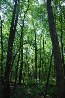
Photo by Josh Mayer
Devil's Lake Oak Forest features a southern dry-mesic forest with an overstory of red oak and a nearly pure understory of red maple. The natural area is part of a deep, scenic gorge incised into the Baraboo Hills by an ancestral Wisconsin River, and later abandoned and partially filled with glacial debris.
The forest is dominated by an even-aged stand of red oak, which originated between 1856 and 1872 according to tree core data. Open-grown white oaks, substantially older and larger than the other canopy trees, are also present. Understory species include American hazelnut, round-leaved dogwood, yellow honeysuckle, and maple-leaved viburnum.
The ground layer contains maidenhair fern, wild sarsaparilla, tall milkweed, blue cohosh, sweet-scented bedstraw, wild geranium, and meadow rue. The forest is situated on top of the terminal moraine of the Cary Glacier, which blocked the ancient river channel. Forest soils are Baraboo and Skillet silt loams; many quartzite and igneous boulders are strewn over the forest floor. Several rare forest-interior birds breed here. Devil's Lake Oak Forest is owned by the DNR and was designated a State Natural Area in 1953.
Very few State Natural Areas have public facilities, but nearly all are open for various recreational activities as indicated below. Generally, there are no picnic areas, restrooms, or other developments. Parking lots or designated parking areas are noted on individual SNA pages and maps. Trails, if present, are typically undesignated footpaths. If a developed trail is present, it will normally be noted on the SNA map under the Maps tab. A compass and topographic map or a GPS unit are useful tools for exploring larger, isolated SNAs.
The good majority of SNAs are isolated and have few or no facilities. Some SNAs have vehicle access lanes or parking lots, but their accessibility may vary depending on weather conditions. Parking lots and lanes are not plowed during winter. Hiking trails may be nonexistent or consist of undeveloped footpaths. A GPS unit or compass and a detailed topographic map are useful tools for exploring larger SNAs.
Entrance fees: Except for Parfrey's Glen, the Cambrian Outlook in the Dells of the Wisconsin River, SNAs within State Parks and some within State Forests, all other DNR-owned SNAs do not have any admission fees. For more information, see Wis. Admin. Code NR 45. For non-DNR-owned SNAs, we are unaware of any vehicle or admission fees. However, please contact the landowner for more information.
Allowable activities: DNR-owned land
The activities listed below are generally allowed on all DNR-owned SNA lands. Exceptions to this list of public uses, such as SNAs closed to hunting, are noted above and posted with signs on the property site.
- Hiking
- Fishing
- Cross country skiing
- Hunting
- Trapping
- Scientific research (permit required)
- Outdoor education
- Wild edibles (What is this?)
- Pets (Rules)
- Wildlife viewing
Prohibited activities: all SNAs
- Camping and campfires
- Collecting of animals (other than legally harvested species), non-edible fungi, rocks, minerals, fossils, archaeological artifacts, soil, downed wood, or any other natural material alive or dead.
- Collecting for scientific research requires a permit issued by the DNR
- Collecting of plants including seeds, roots or other non-edible parts of herbaceous plants such as wildflowers or grasses
- Geocaching
- Horseback riding
- Rock climbing
- Vehicles, including bicycles, ATVs, aircraft, and snowmobiles except on trails and roadways designated for their use.
For rules governing state-owned SNAs and other state lands, please consult Chapter NR 45 Wis. Admin. Code [exit DNR].
Location
Within Devil's Lake State Park, Sauk County. T11N-R6E, Section 24. T11N-R7E, Sections 19, 30. 66 acres.
Driving directions
From the intersection of US Highway 12 and State Highway 136 in West Baraboo, go east (south) on 12 for 3.8 miles, then east on Ski Hi Road for 1.2 miles, then south (right) on South Shore Road to the South Shore main gate and parking/campground area. The natural area lies east of the south shore day use area. Access is provided via the Grottos hiking trail.
The DNR's state natural areas program comprises lands owned by the state, private conservation organizations, municipalities, other governmental agencies, educational institutions, and private individuals. While most SNAs are open to the public, access may vary according to individual ownership policies. Public use restrictions may apply due to public safety, or to protect endangered or threatened species or unique natural features. Lands may be temporarily closed due to specific management activities.
Users are encouraged to contact the landowner for more specific details. The data shown on these maps have been obtained from various sources, and are of varying age, reliability, and resolution. The data may contain errors or omissions and should not be interpreted as a legal representation of legal ownership boundaries. To create your custom map where you can zoom to a specific location, please use the DNR's Mapping Application.
Devil's Lake Oak Forest is owned by: Wisconsin DNR