Dalles Of The St. Croix River
No. 164
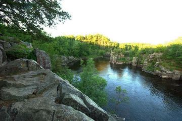
Photo by Josh Mayer
The Dalles of the St. Croix River features an L-shaped segment of the St. Croix River gorge cut through Precambrian basalt by meltwater drainage from Glacial Lake Duluth. Erosion, frost, and gravity acting on the bedrock have resulted in vertical cliffs, unusual pinnacle forms, and rocky talus slopes.
The site is well known for its cylindrical potholes, which were formed by the grinding action of sand and small stones swirling in strong currents. Some of the potholes are quite spectacular in size - up to 6 feet wide and 12 feet deep. Vegetation on the rocky gorge is relatively sparse and dry. Numerous exposures of rounded rock, cliffs, and boulders are barren, while similar sites with more moisture contain polypody fern, fragile fern, rusty woodsia, mosses and lichens.
Areas of sparse dry forest of red cedar, basswood, white pine, and bur, white, and black oaks occur throughout the site. Big blue-stem, blueberry, sumac, long-leaved bluets, bearberry, and poverty oats grass are characteristic plants of the rocky area. Dalles of the St. Croix is owned by the DNR and was designated a State Natural Area in 1980.
Very few State Natural Areas have public facilities, but nearly all are open for various recreational activities as indicated below. Generally, there are no picnic areas, restrooms, or other developments. Parking lots or designated parking areas are noted on individual SNA pages and maps. Trails, if present, are typically undesignated footpaths. If a developed trail is present, it will normally be noted on the SNA map under the Maps tab. A compass and topographic map or a GPS unit are useful tools for exploring larger, isolated SNAs.
The good majority of SNAs are isolated and have few or no facilities. Some SNAs have vehicle access lanes or parking lots, but their accessibility may vary depending on weather conditions. Parking lots and lanes are not plowed during winter. Hiking trails may be nonexistent or consist of undeveloped footpaths. A GPS unit or compass and a detailed topographic map are useful tools for exploring larger SNAs.
Entrance fees: Except for Parfrey's Glen, the Cambrian Outlook in the Dells of the Wisconsin River, SNAs within State Parks and some within State Forests, all other DNR-owned SNAs do not have any admission fees. For more information, see Wis. Admin. Code NR 45. For non-DNR-owned SNAs, we are unaware of any vehicle or admission fees. However, please contact the landowner for more information.
Allowable activities: DNR-owned land
The activities listed below are generally allowed on all DNR-owned SNA lands. Exceptions to this list of public uses, such as SNAs closed to hunting, are noted above and posted with signs on the property site.
- Hiking
- Fishing
- Cross country skiing
- Hunting
- Trapping
- Scientific research (permit required)
- Outdoor education
- Wild edibles (What is this?)
- Pets (Rules)
- Wildlife viewing
Prohibited activities: all SNAs
- Camping and campfires
- Collecting of animals (other than legally harvested species), non-edible fungi, rocks, minerals, fossils, archaeological artifacts, soil, downed wood, or any other natural material alive or dead.
- Collecting for scientific research requires a permit issued by the DNR
- Collecting of plants including seeds, roots or other non-edible parts of herbaceous plants such as wildflowers or grasses
- Geocaching
- Horseback riding
- Rock climbing
- Vehicles, including bicycles, ATVs, aircraft, and snowmobiles except on trails and roadways designated for their use.
For rules governing state-owned SNAs and other state lands, please consult Chapter NR 45 Wis. Admin. Code [exit DNR].
Location
Within Interstate State Park, Polk County. T34N-R18W, Sections 30, 31. T34N-R19W, Sections 25, 36. 87 acres.
Driving directions
From the junction of U.S. Highway 8 and State Highway 35 in St. Croix Falls, go south on 35 0.3 miles to the Interstate Park entrance. Park maps are available at the visitor center. The natural area is reached via the Summit Rock Trail, River Bluffs Trail, and Pothole Trail.
The DNR's state natural areas program comprises lands owned by the state, private conservation organizations, municipalities, other governmental agencies, educational institutions, and private individuals. While most SNAs are open to the public, access may vary according to individual ownership policies. Public use restrictions may apply due to public safety, or to protect endangered or threatened species or unique natural features. Lands may be temporarily closed due to specific management activities.
Users are encouraged to contact the landowner for more specific details. The data shown on these maps have been obtained from various sources, and are of varying age, reliability, and resolution. The data may contain errors or omissions and should not be interpreted as a legal representation of legal ownership boundaries. To create your custom map where you can zoom to a specific location, please use the DNR's Mapping Application.
Dalles Of The St. Croix River is owned by: Wisconsin DNR