Eldorado Wildlife Area
Eldorado Wildlife Area is a 6,381-acre property located in central Fond du Lac County, just north of Hwy 23, and only 5 miles west of the city of Fond du Lac.
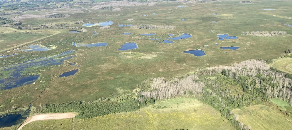
The wildlife area consists of a rich mosaic of wetlands, small oak openings, shrubs, and grasslands. The West Branch of the Fond du Lac River flows through the wildlife area. The property is popular with waterfowl, pheasant and deer hunters.
The dike and access lanes provide a 1 ¼ mile-long gravel surface excellent for wildlife viewing, especially during spring and fall migration and are commonly utilized by walkers, birders and nature enthusiasts.
History
Eldorado Marsh was created by glacial activity from the Wisconsin glacial period, about 10,000 years ago. Native Americans utilized this area for hunting and gathering as evidenced by artifacts found on the property. In 1912, an unsuccessful attempt was made to drain the marsh for agriculture. By the 1920s, farmers realized that they could only cut marsh hay. In 1932, a severe fire burned over much of the area creating numerous deep holes in the peat. Hunters and conservation-minded citizens quickly recognized the value of the marsh for wildlife and initiated its protection. The area was established as a project by the Wisconsin Conservation Commission in 1951. Land acquisition began in 1952 and continues today.
Management objective
The first major step to recreating Eldorado Marsh was taken in 1963 when a 3/4-mile-long dike was constructed across the West Branch of the Fond du Lac River, creating a 1,500-acre shallow water impoundment. Both the wetlands and uplands provide nesting habitat for ducks, geese, wild pheasants, wild turkeys and songbirds. An 865-acre closed area provides a secure area for waterfowl to rest and feed during their migration.
The wildlife area is primarily managed for waterfowl but provides essential habitat for a vast array of wildlife species, including non-game species. While somewhat constrained by natural river flows, an important feature of the wildlife area is the ability to manipulate water levels through the use of the dam and a series of complementing small ponds and wildlife scrapes. Water levels are managed to provide optimal conditions for wetland vegetation and aquatic invertebrates critical for waterfowl production.
Following recent aerial cattail herbicide spraying applications and water level drawdowns, more wild rice can be found onsite. Brush mowing, generally either after the primary nesting season in late summer or over the winter months, is frequently used to set back brush/tree encroachment and maintain grassland habitat. Periodic prescribed burning maintains the health of the grasslands and sets back woody encroachment, benefiting grassland-dependent wildlife species.
Recently, numerous bisecting tree lines have been removed to increase contiguous grassland habitat acreage. An active timber management program is also used to manage the different forest types benefiting wildlife species on the property.
For more information on master planning for this and other wildlife areas around the state, visit the property planning.
Recreation
The Eldorado Wildlife Area offers many recreational opportunities:
- Biking (on bisecting Mascoutin Valley State Trail)
- Birding
- Canoeing
- Dog training
- Cross-country skiing (no designated trail)
- Fishing
- Hiking (Mascoutin Valley State Trail is adjacent to the wildlife area on the south side)
- Hunting (especially noted for waterfowl, wild and stocked ring-necked pheasant (noon closure rule applies), wild turkey and deer — see hunting note below)
- Kayaking
- Trapping
- Snowmobiling trail
- Wild edibles/gathering
- Wildlife viewing
Note: Pets must be on an 8-foot leash from April 15 to July 31. No motor boats (including electric motors) are allowed on the property. Prohibited activities include camping, fires, horseback riding, ATVs, snowmobiles (except on designated trail) and target shooting.
Hunting note: There is an 890-acre closed area during the waterfowl season that is open only for deer during the nine-day gun deer and muzzleloader deer seasons on the north end of the wildlife area. Also, a noon closure applies during a portion of the wild pheasant hunting season.
Amenities
- Bathroom? No.
- Parking lot? Yes, multiple. See the maps section for more details.
- Campground? No.
- Trails? No designated trails, but the dike is a popular walking spot in all seasons.
Maps
Download a map of this property.
If you are interested in exploring this property further, you can access an interactive map.
Directions
Take State Highway 23 west to County Trunk I, and travel north for 1 mile to the southeast corner of the wildlife area. It lies between County Highway N on the north and State Highway 23 on the south.

Find out more about how to adopt this wildlife area.