South Fork Barrens
No. 314
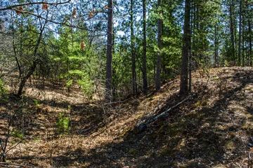
Photo by Aaron Carlson
South Fork Barrens features Jack pine-oak barrens situated on the rolling uplands and steep south-facing bluff above the south fork of the Eau Claire River. The barrens is dominated by Jack pine with bur oak, Hill's oak, and red pine with early low blueberry and American hazelnut common in the understory. Numerous prairie grasses and forbs are scattered through the area and include big and little blue-stem, June grass, lupine, blue toadflax, lance-leaved loosestrife, butterfly milkweed, flowering spurge, bastard toadflax, field wormwood, lyre-leaved rock cress and smooth blue aster. A federally endangered butterfly is found here. Active management including prescribed burning and stopping encroachment of woody species will ensure the long-term viability of the population. South Fork Barrens is owned by Eau Claire County and was designated a State Natural Area in 1996.
Very few State Natural Areas have public facilities, but nearly all are open for a variety of recreational activities as indicated below. Generally, there are no picnic areas, restrooms, or other developments. Parking lots or designated parking areas are noted on individual SNA pages and maps. If a developed trail is present, it will normally be noted on the SNA map and/or under the Maps tab. A compass and topographic map or a GPS unit are useful tools for exploring larger, isolated SNAs.
The good majority of SNAs are isolated and have few or no facilities. Some SNAs have vehicle access lanes or parking lots, but their accessibility may vary depending on weather conditions. Parking lots and lanes are not plowed during winter. Hiking trails may be nonexistent or consist of undeveloped footpaths. A GPS unit or compass and a detailed topographic map are useful tools for exploring larger SNAs.
Non-DNR lands
Entrance fees: For non-DNR-owned SNAs, we are unaware of any vehicle or admission fees. However, please contact the landowner for more information.
Hunting and trapping
Other activities
Other allowable activities such as - but not limited to camping, geocaching and bicycling are determined by the landowner. Please contact them directly or visit their websites for details.
Location
Within Eau Claire County Forest, Eau Claire County. 26N-R5W, Section 14 SW¼. 120 acres.
Driving directions
From the intersection of U.S. Highway 12 and County Highway H in Fairchild, go north on H 10.5 miles, then west 0.5 miles on an unimproved access road (E. Channey Forest Rd) that crosses the site.
The DNR's state natural areas program is comprised of lands owned by the state, private conservation organizations, municipalities, other governmental agencies, educational institutions and private individuals. While the majority of SNAs are open to the public, access may vary according to individual ownership policies. Public use restrictions may apply due to public safety, or to protect endangered or threatened species or unique natural features. Lands may be temporarily closed due to specific management activities.
Users are encouraged to contact the landowner for more specific details. The data shown on these maps have been obtained from various sources, and are of varying age, reliability, and resolution. The data may contain errors or omissions and should not be interpreted as a legal representation of legal ownership boundaries. To create your custom map where you can zoom to a specific location, please use the DNR's Mapping Application.
South Fork Barrens is owned by: Eau Claire County