East Fork Chippewa River
No. 430
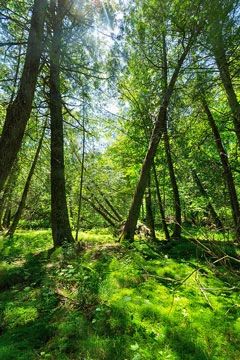
Photo by Josh Mayer
Located along the upper reaches of the East Fork of the Chippewa River, this site includes several mature stands of medium-rich, mesic hardwood forest on drumline ridges. The forest is dominated by sugar maple with basswood and yellow birch. Inter-drumlin areas are forested with mixed swamp hardwoods with remnant hemlock and yellow birch inclusions on somewhat poorly drained soils. Woodland ephemeral ponds with intermittent drainages are commonly associated with these lowland forest communities.
These stands grade down into good quality occurrences of hemlock-dominated forest within the river valley. Co-dominants include upland cedar, white pine, white spruce, and yellow birch. Such stands are especially prevalent along the river margin. Also present is a mature white cedar swamp with black spruce and balsam fir with numerous islands forested with red and white pine. Ground flora species include twinflower, American fly honeysuckle, rattlesnake fern, downy rattlesnake-plantain, dwarf red raspberry, and two-seeded bog sedge. Other associated forested wetland communities include an extensive black spruce-tamarack bog, and a narrow, seasonally flooded black ash and silver maple riparian zone, which is characterized by a fern and sedge-dominated open understory.
Several backwater sloughs are also present, the largest just upstream of Pelican Lake, which is naturally impounded by several sets of rapids downstream. A good diversity of emergent aquatic plants is present within the sloughs which are attractive staging areas for a wide variety of waterfowl and marsh birds during migration. Associated communities include extensive shrub swamps and wet meadow complexes maintained in an open condition by frequent water level fluctuations. In addition to a state-threatened plant, notable species inhabiting the site include bald eagle, river otter, Michigan lily, and purple fringed orchid. East Fork Chippewa River is owned by the US Forest Service and was designated a State Natural Area in 2007.
Very few State Natural Areas have public facilities, but nearly all are open for a variety of recreational activities as indicated below. Generally, there are no picnic areas, restrooms, or other developments. Parking lots or designated parking areas are noted on individual SNA pages and maps. If a developed trail is present, it will normally be noted on the SNA map and/or under the Maps tab. A compass and topographic map or a GPS unit are useful tools for exploring larger, isolated SNAs.
The good majority of SNAs are isolated and have few or no facilities. Some SNAs have vehicle access lanes or parking lots, but their accessibility may vary depending on weather conditions. Parking lots and lanes are not plowed during winter. Hiking trails may be nonexistent or consist of undeveloped footpaths. A GPS unit or compass and a detailed topographic map are useful tools for exploring larger SNAs.
Non-DNR lands
Entrance fees: For non-DNR-owned SNAs, we are unaware of any vehicle or admission fees. However, please contact the landowner for more information.
Hunting and trapping
Other activities
Other allowable activities such as - but not limited to camping, geocaching and bicycling are determined by the landowner. Please contact them directly or visit their websites for details.
Location
Within the Chequamegon-Nicolet National Forest, Ashland County. T41N-R3W, Sections 1, 2, 10-14, 22, 28, 29, 32, 33. T42N-R3W, Sections 35, 36. 1,175 acres.
Driving directions
This site is best seen by water. From the intersection of Highway 13 and County D in Glidden, go south and west on County D about 3.4 miles to Shanagolden. Then continue west on Mertig Road 2.4 miles to the Forest boundary. Continue southwest on FR 167 for 1.5 miles, then southeast on FR 1285 for one mile to a canoe landing. Canoe downstream into the site.
The DNR's state natural areas program is comprised of lands owned by the state, private conservation organizations, municipalities, other governmental agencies, educational institutions and private individuals. While the majority of SNAs are open to the public, access may vary according to individual ownership policies. Public use restrictions may apply due to public safety, or to protect endangered or threatened species or unique natural features. Lands may be temporarily closed due to specific management activities.
Users are encouraged to contact the landowner for more specific details. The data shown on these maps have been obtained from various sources, and are of varying age, reliability, and resolution. The data may contain errors or omissions and should not be interpreted as a legal representation of legal ownership boundaries. To create your custom map where you can zoom to a specific location, please use the DNR's Mapping Application.
East Fork Chippewa River is owned by: US Forest Service