Bonita Country
No. 487
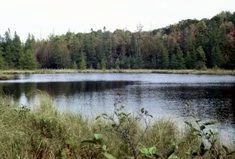
Photo by U.S. Forest Service
Bonita Country supports a large lowland complex containing conifer swamps as part of the watershed feeding the First South Branch Oconto River. Two small lakes are included at the west end of the complex, south of Temple Lake. Upland areas feature a very diverse canopy, including sugar maple, basswood, white ash, beech, red oak, aspen, hemlock, and bitternut hickory. The understory is also diverse and includes the rare species Indian cucumber root (Medeola virginiana) and ginseng (Panax quinquefolius). Other species include maple-leaved viburnum, witch hazel, and hog peanut.
At the east end of the complex, adjacent to the First South Branch of the Oconto River is a forest of red maple, hemlock, cedar, and aspen with abundant rock outcrops, some up to 25 feet tall. These rocks feature common polypody with occasional Canada yew (Taxus canadensis). Super-canopy white pine occurs occasionally in or along the margins of different lowland habitats throughout the complex. Other lowland communities include northern wet-mesic forest, alder thicket, northern sedge meadow, northern wet forest, and open bog. The largest lowland in the ea is the northern wet-mesic forest, with both cedar swamp and mixed conifer swamp. Much of these swamps were strip cut in the late 1970s to late 80s.
Regeneration in the strip cuts is assorted, with balsam fir, black spruce, red alder, and aspen as common re-growth. Two intact areas near the strip cuts have experienced recent flooding and canopy death, presumably from beavers. The best remaining intact swamp is dominated by white cedar with white pine as a frequent canopy component. White pine regeneration is occurring on the ground layer Good quality northern wet forest occurs around and north of the unnamed lake. The forest canopy is black spruce and tamarack, but in places also includes frequent white pine.
The unnamed lake is a picturesque soft-water seepage that contains bluegill and bass. A narrow open bog mat occurs around some portions of the lake. To the north of this lake is a smaller, unnamed, hard water drainage lake with a floating mat resembling both an open bog and a northern sedge meadow community. Bonita Country is owned by the US Forest Service and was designated a State Natural Area in 2007.
Very few State Natural Areas have public facilities, but nearly all are open for a variety of recreational activities as indicated below. Generally, there are no picnic areas, restrooms, or other developments. Parking lots or designated parking areas are noted on individual SNA pages and maps. Trails, if present, are typically undesignated footpaths. If a developed trail is present, it will normally be noted on the SNA map located under the "Map" tab. A compass and topographic map or a GPS unit are useful tools for exploring larger, isolated SNAs.
The good majority of SNAs are isolated and have few or no facilities. Some SNAs have vehicle access lanes or parking lots, but their accessibility may vary depending on weather conditions. Parking lots and lanes are not plowed during winter. Hiking trails may be nonexistent or consist of undeveloped footpaths. A GPS unit or compass and a detailed topographic map are useful tools for exploring larger SNAs.
Non-DNR lands
Entrance fees: For non-DNR-owned SNAs, we are unaware of any vehicle or admission fees. However, please contact the landowner for more information.
Hunting and trapping
Other activities
Other allowable activities such as - but not limited to camping, geocaching and bicycling are determined by the landowner. Please contact them directly or visit their websites for details.
Location
Within the Chequamegon-Nicolet National Forest. Oconto County. T31N-R15E, Section 24. T31N-R16E, Sections 19, 20, 29, 30. 1,176 acres.
Driving directions
The site is located approximately 3.5 to 6 miles southwest of Mountain, Wisconsin. The north end of the site neighbors Temple Lake. The south end of the complex borders Menominee County. The site is accessible from County Highway W and Forest Roads 2112 and 2964. From Mountain, go west on County W for 4.9 miles, then south on Bonita Road for 0.7 miles. Walk east into the site.
The DNR's state natural areas program is comprised of lands owned by the state, private conservation organizations, municipalities, other governmental agencies, educational institutions, and private individuals. While the majority of SNAs are open to the public, access may vary according to individual ownership policies. Public use restrictions may apply due to public safety, or to protect endangered or threatened species or unique natural features. Lands may be temporarily closed due to specific management activities.
Users are encouraged to contact the landowner for more specific details. The data shown on these maps have been obtained from various sources, and are of varying age, reliability, and resolution. The data may contain errors or omissions and should not be interpreted as a legal representation of legal ownership boundaries. To create your custom map where you can zoom to a specific location, please use the DNR's Mapping Application.
Bonita Country is owned by: The US Forest Service