Remote Sensing: Future Directions
Future remote sensing research activities at the DNR will concentrate on an increase in Earth observation monitoring capabilities. These research activities include the optical and biogeochemical characterization of lakes across Wisconsin and the development of models for the retrieval of the concentrations of algal pigments, suspended solids, and colored dissolved organic matter (CDOM) for current and future satellite sensors.
Physical principles of the remote sensing of water quality
Models for the remote sensing of water quality depend on the relationship of the light reflected from a lake, called the remote sensing reflectance, Rrs(λ), and the inherent optical properties of the constituents, comprised of the absorption coefficient, a(λ), and the backscattering coefficient, bb(λ). The remote sensing reflectance depends on the solar zenith angle, θ, solar azimuth angle, φ, and wavelength, λ, (Zibordi et al., 2012) and the distinctive spectral signatures of lakes are the result of variations in a(λ) and bb(λ). The inherent optical properties of the constituents provide information for the development of models for the retrieval of the concentrations of the constituents of interest from the remote sensing reflectance.
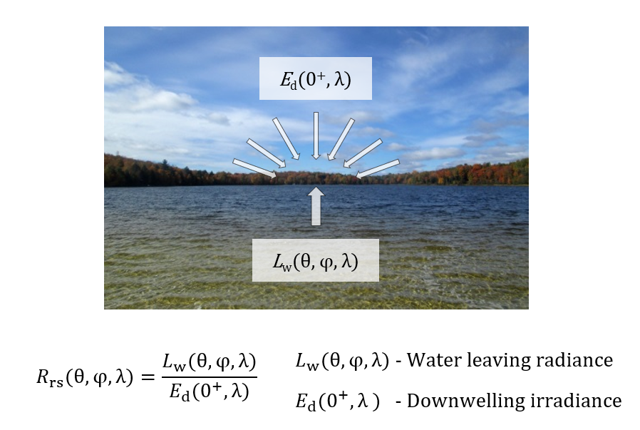
Calculation of the remote sensing reflectance of waterbodies.
This equation relates the ratio of the water leaving radiance and the downwelling irradiance (𝐿w(θ,φ,λ) and 𝐸d(0+, λ)) to the remote sensing reflectance (𝑅rs(θ,φ,λ)).
The figure shows a picture of Spectacle Lake in Vilas County overlaid with two sets of white arrows to represent the water leaving radiance and the downwelling irradiance (𝐿w(θ,φ,λ) and 𝐸d(0+, λ)). The figure shows the equation to translate this information to the remote sensing reflectance (𝑅rs(θ,φ,λ)) in addition to the picture.
Remote sensing reflectance spectra of lakes
Remote sensing reflectance spectra represent the spectral signatures of lakes and are determined by the inherent optical properties of the constituents. The distinctive reflectance features of lakes in the blue spectral region are related to the presence of algal pigments, non-algal particles, and CDOM. The spectral features in the red spectral region are mainly related to the presence of algal pigments.
The remote sensing reflectance spectrum for Trout Lake from 07/21/2015 is typical for many clear lakes in northern Wisconsin and shows a small reflectance trough at a wavelength of 668 nm related to the presence of chlorophyll-a. This spectral feature is used to differentiate chlorophyll-a from the rest of the constituents and to develop models for the retrieval of the concentration of chlorophyll-a from remote sensing data.
The remote sensing reflectance spectrum for the Spirit River Flowage from the same day is typical for some of the stained lakes and their high concentrations of CDOM in northern Wisconsin. The reflectance in the blue spectral region is practically zero and the increase in reflectance in the green spectral region seen in the spectrum for Trout Lake is suppressed by the presence of CDOM. The remote sensing reflectance spectrum for the Spirit River Flowage shows reflectance troughs at wavelengths of 614 and 678 nm related to the presence of cyanophycocyanin and chlorophyll-a. The reflectance trough related to the presence of cyanophycocyanin is at a much shorter wavelength than expected in consequence of the combined absorption by CDOM and cyanophycocyanin.
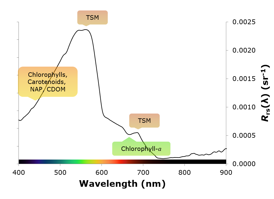
Remote sensing reflectance spectrum for Trout Lake acquired on 07/21/2015.
This remote sensing reflectance spectrum is typical for many clear lakes in northern Wisconsin (NAP – non-algal particles, CDOM – colored dissolved organic matter, and TSM – total suspended matter).
The x-axis of this line chart shows the wavelength (Wavelength (nm)) for values from 400 to 900 nm and the secondary y-axis shows the remote sensing reflectance (𝑅rs(λ) (sr-1)) for values from 0.0000 to 0.0025 sr-1. The spectrum for Trout Lake has distinctive reflectance features typical for many clear lakes in northern Wisconsin.
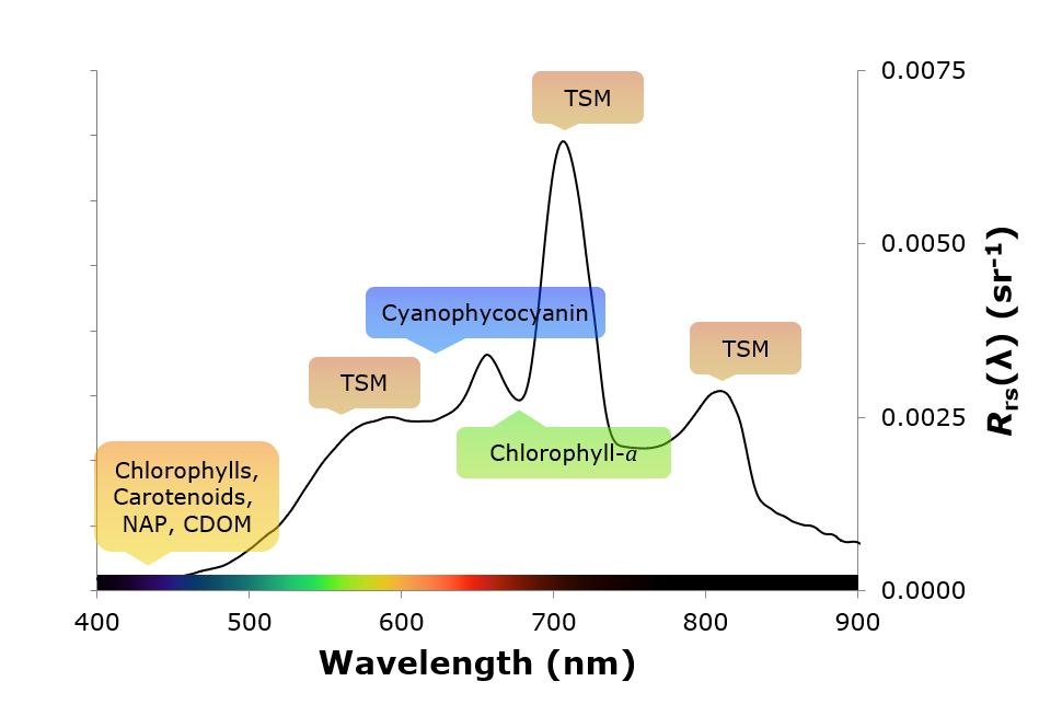
Remote sensing reflectance spectrum for the Spirit River Flowage acquired on 07/21/2015.
This remote sensing reflectance spectrum is typical for some of the stained lakes and their high concentrations of CDOM in northern Wisconsin (NAP – non-algal particles, CDOM – colored dissolved organic matter, and TSM – total suspended matter).
The x-axis of this line chart shows the wavelength (Wavelength (nm)) for values from 400 to 900 nm and the secondary y-axis shows the remote sensing reflectance (𝑅rs(λ) (sr-1)) for values from 0.0000 to 0.0075 sr-1. The spectrum for the Spirit River Flowage has distinctive reflectance features typical for some of the stained lakes and their high concentrations of CDOM in northern Wisconsin. The comparison of these spectra shows the importance of specific spectral regions for the retrieval of water quality from remote sensing data.
Development of models for current and future satellite sensors
Data collection activities for the development of models for the retrieval of the concentrations of algal pigments, suspended solids, and CDOM for current and future satellite sensors include field measurements of remote sensing reflectance spectra for lakes across Wisconsin. These measurements are used to model the spectral bands of satellite sensors capable of the differentiation of the constituents of interest and to calibrate and validate models for the retrieval of water quality data for these sensors.
Satellite sensors with relevance for the remote sensing of water quality within Wisconsin’s lakes include the Sentinel-2 MultiSpectral Instrument (MSI) and Sentinel-3 Ocean and Land Colour Instrument (OLCI).
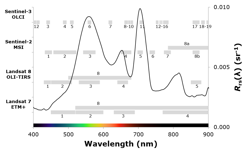
Comparison of the spectral bands of four satellite sensors with relevance for the remote sensing of water quality.
The Sentinel-3 OLCI sensor includes several spectral bands for the monitoring of water quality and the detection of algal blooms. The reflectance peaks and troughs seen in the remote sensing reflectance spectrum for Lake Winnebago acquired on 09/21/2015 and represented by Sentinel-3 OLCI bands 7, 8 - 10, and 11 are used for the detection and quantification of algal blooms in inland and coastal waters.
The x-axis of this line chart shows the wavelength (Wavelength (nm)) for values from 400 to 900 nm and the secondary y-axis shows the remote sensing reflectance (𝑅rs(λ) (sr-1)) for values from 0.000 to 0.010 sr-1. The primary y-axis lists the satellite sensors Landsat 7 ETM+, Landsat 8 OLI-TIRS, Sentinel-2 MSI, and Sentinel-3 OLCI. The spectral bands of these satellite sensors are overlaid with the reflectance spectrum for Lake Winnebago to compare the potential of these four satellite sensors for the monitoring of water quality and the detection of algal blooms.
Reference
Zibordi, G., Ruddick, K., Ansko, I. Moore, G., Kratzer, S., Icely, and J. Reinart (2012): In situ determination of the remote sensing reflectance: an inter-comparison. Ocean Science, 8, 567-586