Remote Sensing of Water Quality
Remote sensing presents a cost efficient complementary approach for a more comprehensive assessment of lakes across Wisconsin. The use of remote sensing for the assessment of our aquatic resources provides several advantages compared to conventional approaches for water quality assessments.
Remote sensing provides water quality data with a high spatial and temporal resolution for thousands of lakes at a time. It supports the evaluation of environmental problems and potential health risks through the analysis of changes in water quality and the detection of harmful algal blooms. Several remote sensing programs provide historical data for studies of trends in water quality and the potential impacts of land use and land cover change on water quality. The real time availability of remote sensing data makes it possible to integrate it into early warning systems to protect the public from harmful algal blooms.
(Source of Landsat 8 OLI data: U.S. Geological Survey)
Satellite retrieval of water quality data for lakes is complicated by the optically complex conditions found in lakes, potential interference from the lake bottom in shallow lakes, and dynamic changes in water quality. The remote sensing of water quality is limited to the retrieval of water clarity, turbidity, water color, and the concentrations of optically active constituents. These include the concentrations of algal pigments, suspended solids, and colored dissolved organic matter (CDOM). The DNR routinely retrieves the water clarity from thousands of lakes across Wisconsin and will expand its remote sensing capabilities to include the concentrations of optically active constituents in the future. The calibration and validation of models for the retrieval of water quality data from satellite images typically requires the collection of ground truth data and the laboratory analysis of water samples.
The development of capabilities for the remote sensing of water quality in Wisconsin started in 1999 when Citizen Lake Monitoring Network (CLMN) volunteers assisted in a collaborative research effort with the University of Wisconsin-Madison Environmental Remote Sensing Center (ERSC) to develop a model for the retrieval of water clarity data from satellite images. CLMN volunteers collected on-the-ground Secchi depth data when the satellites were overhead to calibrate this model for each satellite image and water clarity data was retrieved for over 8,000 lakes statewide between 1999 and 2001. This research effort provided the foundation for the operational remote sensing of water clarity at the DNR in subsequent years. Today remote sensing data from the NASA/USGS Landsat Program are used by the DNR to provide satellite retrieved Secchi depth data for thousands of lakes annually with the support of CLMN volunteers.
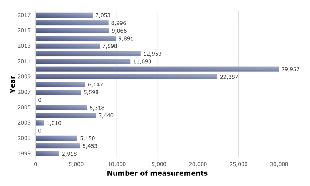
Number of satellite-retrieved Secchi depth measurements from 1999 to 2017.
(Source of water clarity data: Wisconsin DNR Surface Water Integrated Monitoring System)
The x-axis of this bar chart shows the number of measurements from 0 to 30,000 for each year while the y-axis indicates the year from 1999 to 2017. The measurements from 1999 to 2001 represent the collaborative research effort with the University of Wisconsin-Madison ERSC and the measurements from 2003 to 2017 are results from the continued analysis of satellite data at the DNR. The number of satellite-retrieved Secchi depth measurements ranges from 1,010 in the year 2003 to 29,957 in the year 2010 and comprises 18 years of data.
Current remote sensing activities at the DNR include the systematic processing of satellite data for the retrieval of water clarity, the use of satellite retrieved water clarity data for the assessment of trends in water quality, and the development of new interactive ways to present the satellite retrieved water clarity data for public use through the Lakes and Aquatic Invasive Species (AIS) Mapping Tool.