Water levels and your property
In order to provide the DNR accurate, quantifiable information about how changing lake levels will affect your property, this information is provided to help you find the current water level and compare it to the shoreline of your property.
Find the water level on Lake Koshkonong
The U.S. Geological Survey maintains a gauge on Lake Koshkonong. It is located near the Pottawatomi Trail Bridge at Bingham Point Estates. The gauge is updated many times a day and is reported on the USGS website: USGS 05427235 Lake Koshkonong near Newville, WI.
Interpreting the gauge height graph
If you scroll down the USGS webpage, you will see:
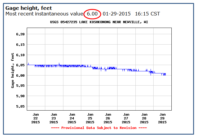
In the red circle is the last water level reading taken. In this example, the water gauge reports a level of 6.00 on Jan. 29, 2015 at 4:15 pm.
Additionally, the graph above shows previous week's water levels.
Measurement conversion for point of reference
To convert the gauge reading into the DNR water level order's datum or point of reference, add 770.00. Using the example above, the resulting water level is 6.00' + 770.00' = 776.00'.
The numbers after the decimal point are still feet - they are not inches. If the water level were 776.25', that would mean 776 feet and 3 inches.
Previous water levels
Use the same website to find a water level for a day in the past. Near the top of the page is a dark blue banner that reads: "Available data for this site". Click on the down arrow in the box and select "Time series: Daily data". Scroll down to the middle of the page and inside a dark blue, double-line-bordered box you can type in the “Begin date” and “End date” for the period of time you want the lake levels.
Determine what the water level means on your property
After you have determined the lake level from the USGS gauge, you can see how that level looks on your property. A water level will look different on everyone's shoreline depending on the elevations of your property and the property's shape. The same water level can be at the bottom of the lake bank on one property but at the top of the bank on someone else’s property. That’s because some properties are at higher elevations. The same water level can be deep near shore on one property and shallow at someone else's. That again is based on the water level or water elevation and lakebed elevation.
Water levels are vertical measurements of how much the water goes up and down. It doesn't mean how much farther the water spreads out. If you were to stand in the lake at the exact same place day after day and the water level went up and down one foot, the water would go from about your ankle to about your knee. If you looked at the shore when the water is at the ankle, the water's edge is closer to you than when the water is at your knees. The water level does not measure the change in the distance of the water's edge.
