Groundwater levels and aquifer response
Monitoring groundwater levels can be used for:
- understanding local water resources;
- assessing aquifers in drought or wet conditions;
- assessing groundwater divides and surface water impacts;
- calibrating groundwater flow models and other decision-support tools; and
- helping to determine the relationship between water resources and withdrawals.
Groundwater Level Monitoring
The DNR and its partners at the United States Geological Survey (USGS) and the Wisconsin Geological and Natural History Survey (WGNHS) collectively operate and maintain a statewide network of monitoring wells that provide necessary long-term data for Wisconsin's statewide water resources inventory. The groundwater monitoring network, started in 1946, now consists of nearly 100 long-term monitoring wells that measure groundwater levels in aquifers across the state.
The DNR's water quantity data viewer shows the location and water levels associated with the statewide groundwater monitoring network.
Groundwater Level Fluctuations
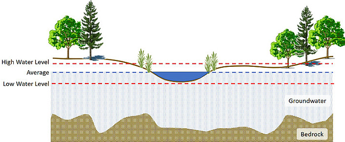
The upper surface of groundwater, referred to as the water table, can fluctuate in response to precipitation events and water withdrawals. During times of drought, local water tables can decline due to decreased recharge and increased water use (e.g. watering lawns, irrigating farm fields, municipal water supply). The result is that the water table can fall below surface water resources or from wells that withdraw water from the aquifer (see diagram below).
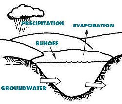
The opposite can also occur, resulting in a high water table (too much groundwater). Groundwater flooding occurs when frequent, sustained rainfall leads to excessively fast recharge of local groundwater levels and the water table rises above the land surface. This type of flood may be pronounced near seepage lakes (see diagram below). This type of flood can be long-lasting because water table decline requires drainage from the entire aquifer above the flood level. For the time that it takes for this drainage to occur, flood waters can cause significant property loss, human displacement and disruption of transportation.
Floods and droughts are part of life in Wisconsin and elsewhere, but they come with significant economic, public health and environmental costs.
groundwater, precipitation and limited
runoff. It does not have a stream outlet.
Image credit: UW-Stevens Point.
Seepage lakes may also experience flooding of shoreline beaches and buildings due to a rise in the water table elevation and the related long-term increase in lake levels. Floods and droughts are part of life in Wisconsin and elsewhere, but they come with significant economic, public health and environmental costs.
During years when Wisconsin receives a record-breaking amount of precipitation, many areas in Wisconsin experience high water and flooding issues. Information is available from the DNR to help residents cope with flooding. It may be difficult to determine if nearby flooding is due to surface water or groundwater flooding. For example, increased groundwater flow to nearby streams and rivers may cause the waterbodies to flood; or storm sewers that typically would drain to rivers don't work properly if too much inflow into the pipes from groundwater is occurring.
Status of Groundwater Levels
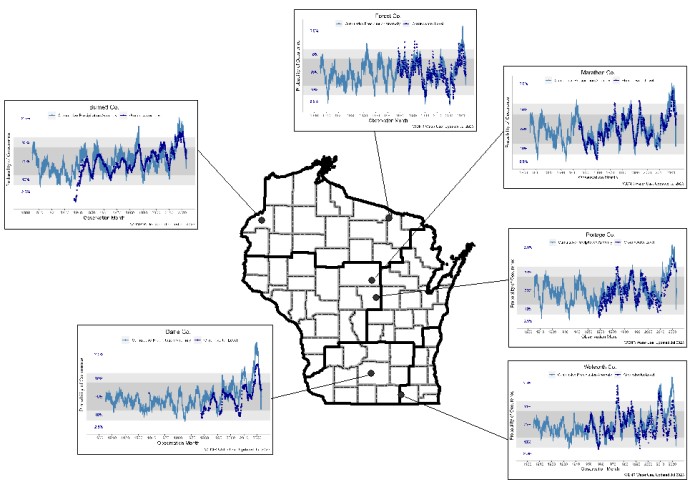
After a period of above-average precipitation amounts from 2017-2020, groundwater levels were at or near all-time highs in 2020 and 2021. After a period of more typical precipitation amounts (2022) to below-average precipitation amounts (2023), groundwater levels have begun declining.
View the regional charts to see the status of water levels as compared to the long-term average, as well as the relationship between precipitation and groundwater:
- Northwest - Burnett Co.
- Northeast - Forest Co.
- West Central - Marathon Co.
- Central - Portage Co.
- South Central - Dane Co.
- Southeast - Walworth Co.
Note: reading the charts — probability of occurrence
Flooding Resources
- Fluctuating lake levels
- Recommendations for private wells inundated by flooding
- Coping with flooding
- Flood insurance
- High groundwater and flooding
More Information About Groundwater


