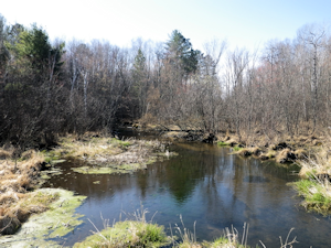
Spring Creek Fishery Area
DNR Fisheries Areas
The original 42.73 acres of Spring Creek Fishery area was purchased in 1967 with an additional 30 acres being added in 1987.
Location/Directions
To reach the Fishery Area, travel north on County Hwy X .5 mile and turn east on Larrabee Road. Travel .7 miles and turn north onto the access easement and drive .4 miles to the parking lot at the south end of the property.
Activities
Angling opportunities
Anglers can gain access to Spring Creek by carry in access, walking along shore and kayak. The primary species sought by anglers is brook trout. See Trout stream information, classifications, maps etc.
Recreational Opportunities
|
|
Objective
The primary management goal is to protect the trout habitat of Spring Creek, its tributaries and springs. Upland habitat is managed to protect the spring pond and creek while providing wildlife habitat, timber values and compatible outdoor recreational opportunities. Timber sales are the primary management method for upland habitats. Almost annual stocking of fingerling size brook trout provides angling opportunities for sportsmen.
Contacts/Partners
For questions and comments contact:
Property Manager
Department of Natural Resources
810 W Maple Street
Spooner WI 54801
715-635-4022
Fisheries Biologist
Department of Natural Resources
810 W Maple Street
Spooner WI 54801
715-635-4095