Yellow River Ice-Walled Lake Plain
No. 467
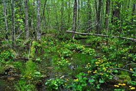 Photo by Aaron Carlson
Yellow River Ice-walled Lake Plain features a fairly large and relatively undisturbed ice-walled lake plain that is probably unmatched in species richness – for this landform – anywhere else in the Chequamegon-Nicolet National Forest. Ice-walled lake plains are common on the end moraine of the Chippewa Lobe, which marks the farthest advance of ice during the last part of the Wisconsin Glaciation. However, because of their comparatively flat surfaces and fertile boulder-free soils within an otherwise rugged end moraine, most ice-walled lake plains have long since been converted to agriculture while most similar sites within the Forest boundary have been highly used for timber production. This one supports a rich mesic hardwood forest that supports a species composition more typical of a southern mesic forest with sugar maple and basswood dominating the canopy. Associates include white ash, red oak, bitternut hickory, and butternut.
The understory is fairly open and the shrub layer is poorly developed. The ground flora includes an outstanding display of spring ephemeral wildflowers and is exceptionally rich with species including squirrel corn, toothwort, false rue-anemone, dog-tooth violet, Virginia water-leaf, sharp-lobed hepatica, bloodroot, rosy twisted stalk, Goldie's fern, and bulblet bladder fern. Numerous rare plants also occur here. Other high-ranking communities include a rich, mixed swamp hardwood forest that has developed on a perched wetland found on the somewhat poorly drained interior of the lake plain.
This swamp forest is drained by several well-developed erosion channels which are served at the original outlet when the surrounding glacial ice melted away. Linked to the site by a typical wet black ash swamp along a riparian drainage, is a representative stand of good quality hemlock-hardwood forest characteristic of the original forest which historically dominated extensive areas of the end moraine. The forest is composed of large hemlock, yellow birch, and sugar maple. Characteristic herbaceous species are Canada mayflower, yellow blue bead lily, mountain wood sorrel, three-leaved goldthread,
American starflower, partridgeberry, bunchberry, and numerous ferns. Super-canopy white pine is present. The ice-walled lake plain drains to both the north and south by rather striking dendritically-patterned erosion channels with steep sides and depths up to 25 feet below the surface of the plain. Many fern species thrive in the moist, shady microclimate of these ravines and hemlock is frequent on the steep slopes. Rare birds include the cerulean warbler (Dendroica cerulea) and black-throated blue warbler (D. caerulescens). Other resident birds include ovenbird, red-eyed vireo, wood thrush, least flycatcher, and scarlet tanager. Yellow River Ice-walled Lake Plain is owned by the US Forest Service and was designated a State Natural Area in 2007.
Very few State Natural Areas have public facilities, but nearly all are open for a variety of recreational activities as indicated below. Generally, there are no picnic areas, restrooms, or other developments. Parking lots or designated parking areas are noted on individual SNA pages and maps. Trails, if present, are typically undesignated footpaths. If a developed trail is present, it will normally be noted on the SNA map and/or under the Maps tab. A compass and topographic map or a GPS unit are useful tools for exploring larger, isolated SNAs.
The good majority of SNAs are isolated and have few or no facilities. Some SNAs have vehicle access lanes or parking lots, but their accessibility may vary depending on weather conditions. Parking lots and lanes are not plowed during winter. Hiking trails may be nonexistent or consist of undeveloped footpaths. A GPS unit or compass and a detailed topographic map are useful tools for exploring larger SNAs.
Non-DNR lands
Entrance fees: For non-DNR-owned SNAs, we are unaware of any vehicle or admission fees. However, please contact the landowner for more information.
Hunting and trapping
Other Activities
Other allowable activities such as - but not limited to camping, geocaching and bicycling are determined by the landowner. Please contact them directly or visit their websites for details.
Location
Within the Chequamegon-Nicolet National Forest. Taylor County. T32N-R2W, Sections 16-21. 722 acres.
Driving Directions
From Perkinstown, go north on County M for 2.1 miles, then continue north on FR 112 for 0.9 miles, then west on FR 575 (Sheep Ranch Road) 1.5 miles into the site. The site lies on both sides of the road.
The DNR's state natural areas program is comprised of lands owned by the state, private conservation organizations, municipalities, other governmental agencies, educational institutions and private individuals. While the majority of SNAs are open to the public, access may vary according to individual ownership policies. Public use restrictions may apply due to public safety, or to protect endangered or threatened species or unique natural features. Lands may be temporarily closed due to specific management activities. Users are encouraged to contact the landowner for more specific details.
The data shown on these maps have been obtained from various sources, and are of varying age, reliability, and resolution. The data may contain errors or omissions and should not be interpreted as a legal representation of legal ownership boundaries.
To create your custom map where you can zoom to a specific location, please use the DNR's mapping application.
Yellow River Ice-walled Lake Plain is owned by: U.S. Forest Service