Wyalusing Hardwood Forest
No. 5
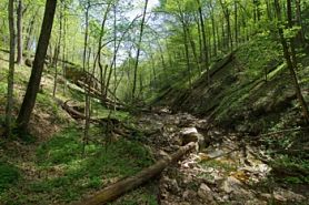 Photo by Thomas A. Meyer/DNR
Wyalusing Hardwood Forest occupies the steep sides and top of a ridge just east of the confluence of the Wisconsin and Mississippi Rivers and contains four major southern forest types illustrating John Curtis’ classic concept of a vegetation continuum. The wooded bluffs rise more than 400 feet above the Wisconsin River and provide a variety of exposures over different bedrock types including Prairie du Chien and Platteville-Galena dolomites and St. Peter sandstone. The major soil types, Fayette and Seaton silt loams, developed in loess. The river bottoms have a wet-mesic forest dominated by silver maple. Upslope there are areas of mesic, dry-mesic, and dry forest. The ground layer species are equally diverse, changing in composition with changes in microclimate. Nesting birds are characteristic of locations much farther south and include several rare forest interior species. Also present are blue-gray gnatcatcher and tufted titmouse. The forest was dedicated to Dr. John T. Curtis, the first chair of the State Board for the Preservation of Scientific Areas, in May 1966. Wyalusing Hardwood Forest is owned by the DNR and was designated a State Natural Area in 1952.
Very few State Natural Areas have public facilities, but nearly all are open for a variety of recreational activities as indicated below. Generally, there are no picnic areas, restrooms, or other developments. Parking lots or designated parking areas are noted on individual SNA pages and maps. Trails, if present, are typically undesignated footpaths. If a developed trail is present, it will normally be noted on the SNA map and/or under the Maps tab. A compass and topographic map or a GPS unit are useful tools for exploring larger, isolated SNAs.
The good majority of SNAs are isolated and have few or no facilities. Some SNAs have vehicle access lanes or parking lots, but their accessibility may vary depending on weather conditions. Parking lots and lanes are not plowed during winter. Hiking trails may be nonexistent or consist of undeveloped footpaths. A GPS unit or compass and a detailed topographic map are useful tools for exploring larger SNAs.
Entrance fees: Except for Parfrey's Glen, the Cambrian Outlook in the Dells of the Wisconsin River, SNAs within State Parks and some within State Forests, all other DNR-owned SNAs do not have any admission fees. For more information, see Wis. Admin. Code NR 45 [exit DNR]. For non-DNR-owned SNAs, we are unaware of any vehicle or admission fees. However, please contact the landowner for more information.
ALLOWABLE ACTIVITIES: DNR-OWNED LAND
The activities listed below are generally allowed on all DNR-owned SNA lands. Exceptions to this list of public uses, such as SNAs closed to hunting, are noted above and posted with signs on the property site.
- Hiking
- Fishing
- Cross country skiing
- Hunting
- Trapping
- Scientific research (permit required [PDF])
- Outdoor education
- Wild edibles (What is this?)
- Pets (Rules)
- Wildlife viewing
PROHIBITED ACTIVITIES: ALL SNAS
Although a handful of sites allow activities like primitive camping (e.g. Lower Chippewa River on sand bars) or horseback riding (e.g. S. Kettle Moraine), the activities listed below are generally prohibited on DNR-owned SNAs.
- Camping and campfires
- Collecting of animals (other than legally harvested species), non-edible fungi, rocks, minerals, fossils, archaeological artifacts, soil, downed wood, or any other natural material, alive or dead. Collecting for scientific research requires a permit issued by the DNR
- Collecting of plants including seeds, roots or other non-edible parts of herbaceous plants such as wildflowers or grasses
- Drones: Flying-related activities, including the use of drones, hang-gliders and model airplanes, are prohibited. Permission may be issued by the SNA Program for the use of drones for educational or research purposes.
- Geocaching
- Horseback riding
- Rock climbing
- Vehicles, including bicycles, ATVs, aircraft, and snowmobiles except on trails and roadways designated for their use
For rules governing state-owned SNAs and other state lands, please consult Chapter NR 45 Wis. Admin. Code [exit DNR].
Location
Within Wyalusing State Park, Grant County. T6N-R6W, Sections 15, 16, 22. 403 acres.
Driving Directions
From the intersection of Highways 18 and 60 in Bridgeport, go east on 18 for about 1.2 miles, then west on County Highway C for 3.1 miles, then west on County Highway X for just over one mile, then north into Wyalusing State Park on the park road 0.4 miles to the visitor center. Pay the admission fee and get a park map. Continue 0.9 miles along the road to the trailhead for the Sand Cave Trail on the east side of the road. Although the trail approaches within 1/4 mile of the western boundary of the natural area, there are no trails to or within the natural area itself. Use a GPS unit or detailed map and compass to navigate to the site.
The DNR's state natural areas program is comprised of lands owned by the state, private conservation organizations, municipalities, other governmental agencies, educational institutions and private individuals. While the majority of SNAs are open to the public, access may vary according to individual ownership policies. Public use restrictions may apply due to public safety, or to protect endangered or threatened species or unique natural features. Lands may be temporarily closed due to specific management activities. Users are encouraged to contact the landowner for more specific details.
The data shown on these maps have been obtained from various sources, and are of varying age, reliability, and resolution. The data may contain errors or omissions and should not be interpreted as a legal representation of legal ownership boundaries.
To create your custom map where you can zoom to a specific location, please use the DNR's mapping application.
Wyalusing Hardwood Forest is owned by: Wisconsin DNR