Woods Creek
No. 457
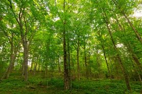 Photo by Josh Mayer
Woods Creek features northern mesic, wet-mesic, and wet forests within a wetland mosaic of numerous ephemeral ponds and small bogs and swamps in a hummocky landscape. A tributary of Woods Creek breaches a well-developed moraine ridge. One-quarter mile of the ridge lies within the site boundary. Along the southern edge of the Moraine ridge, there appears to be terracing. The origin of the terracing and breach is not found in any literature, but it appears that the terracing arose from lake waters that were dammed by the morainal ridge to the south. The tributary appears to be the remnant of the waters that once breached the moraine.
The northern dry-mesic forest features super-canopy white pine, large hemlock, and a surprising amount of upland northern white cedar. Relict white pine is commonly 30 inches or more in diameter and estimated at 200 years old, predating the earliest logging episodes. The hemlock grades into the swamps below and into a northern mesic forest where it increases in abundance. Large sugar maples are also present. Stumps of white pine and other species were common, some harvested within the past few decades. However, the canopy is still intact. Snags, den trees, and coarse woody debris are present although not common. The understory includes bunchberry, black cherry, early low blueberry, beaked hazelnut, yellow blue bead lily, American starflower, and wild sarsaparilla.
Along the moraine and in the western portions, the forest has been more recently and frequently cut resulting in a stand with more pole-sized sugar maple. Hemlock with yellow birch, white cedar, and occasional super-canopy white pine dominate the northern mesic forest. In areas with a 70% closed canopy, the understory was thick with red raspberry, sugar maple seedlings, lycopods, and beaked hazelnut. Black spruce, white cedar, tamarack, and sphagnum moss dominate the northern wet forest. Understory species include leather-leaf, labrador tea, and sedges. Documented breeding birds include winter wren, magnolia warbler, chestnut-sided warbler, black and white warbler, ovenbird, rose-breasted grosbeak, red-eyed vireo, and white-throated sparrow. Woods Creek is owned by the US Forest Service and was designated a State Natural Area in 2007.
Very few State Natural Areas have public facilities, but nearly all are open for various recreational activities as indicated below. Generally, there are no picnic areas, restrooms, or other developments. Parking lots or designated parking areas are noted on individual SNA pages and maps. Trails, if present, are typically undesignated footpaths. If a developed trail is present, it will normally be noted on the SNA map and/or under the Maps tab. A compass and topographic map or a GPS unit are useful tools for exploring larger, isolated SNAs.
The good majority of SNAs are isolated and have few or no facilities. Some SNAs have vehicle access lanes or parking lots, but their accessibility may vary depending on weather conditions. Parking lots and lanes are not plowed during winter. Hiking trails may be nonexistent or consist of undeveloped footpaths. A GPS unit or compass and a detailed topographic map are useful tools for exploring larger SNAs.
Hunting and trapping
Allowable activities: DNR-owned land
The activities listed below are generally allowed on all DNR-owned SNA lands. Exceptions to this list of public uses, such as SNAs closed to hunting, are noted above and posted with signs on the property site.
- Hiking
- Fishing
- Cross country skiing
- Hunting
- Trapping
- Scientific research (permit required [PDF])
- Outdoor education
- Wild edibles (What is this?)
- Pets (Rules)
- Wildlife viewing
Prohibited activities: all SNAs
- Camping and campfires
- Collecting of animals (other than legally harvested species), non-edible fungi, rocks, minerals, fossils, archaeological artifacts, soil, downed wood, or any other natural material, alive or dead. Collecting for scientific research requires a permit issued by the DNR
- Collecting of plants including seeds, roots or other non-edible parts of herbaceous plants such as wildflowers or grasses
- Geocaching
- Horseback riding
- Rock climbing
- Vehicles, including bicycles, ATVs, aircraft, and snowmobiles except on trails and roadways designated for their use
For rules governing state-owned SNAs and other state lands, please consult Chapter NR 45 Wis. Admin. Code [exit DNR].
Location
Within the Chequamegon-Nicolet National Forest. Florence County. T39N-R15E, Sections 25, 26, 27, 34, 35. 420 acres.
Driving directions
From the intersection of Highway 139 and FR 2156 (Halsey Lake Road) in Long Lake, go east on FR 2156 for approximately 5.3 miles. Walk south into the site.
The DNR's state natural areas program is comprised of lands owned by the state, private conservation organizations, municipalities, other governmental agencies, educational institutions and private individuals. While the majority of SNAs are open to the public, access may vary according to individual ownership policies. Public use restrictions may apply due to public safety, or to protect endangered or threatened species or unique natural features. Lands may be temporarily closed due to specific management activities. Users are encouraged to contact the landowner for more specific details.
The data shown on these maps have been obtained from various sources, and are of varying age, reliability, and resolution. The data may contain errors or omissions and should not be interpreted as a legal representation of legal ownership boundaries.
To create your custom map where you can zoom to a specific location, please use the DNR's mapping application.
Woods Creek is owned by: U.S. Forest Service and the Wisconsin DNR