Woodland Dunes
No. 252
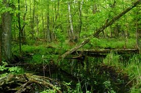 Photo by Josh Mayer
Woodland Dunes features a low area of ridge and swale topography near Lake Michigan, similar to that at Point Beach State Forest a few miles to the north. The series of narrow, parallel sand ridges represent former beach lines of Lake Michigan as water levels fell during post-glacial times. The ridges are separated by perennially wet swales. About two-thirds of the ridges are timbered with aspen, white birch, and red maple; the remaining third support a mature forest of yellow birch, beech, hemlock, and white pine.
The understory contains elements typical of a northern mesic forest, including shining club moss, spinulose wood fern, American starflower, naked miterwort, and yellow-blue-bead-lily. Ash, elm, and alder dominate the swales with occasional patches of dogwood, willow, and sedges. White cedar, with occasional tamarack, is also found in the swales and on the ridge edges. Woodland Dunes, with its variety of habitats and proximity to Lake Michigan, is used by a great diversity of birds. Shorebirds utilize a nearby river marsh and often forage in adjacent farm fields. Songbirds, especially warblers and thrushes, make use of the forested portions of the dunes during migration. More southerly bird species like blue-gray gnatcatcher and white-eyed vireo are at the northern edge of their range here.
The natural area is an excellent place to view all of Wisconsin’s raptors during their fall migration down the lakeshore. Woodland Dunes is owned and managed by Woodland Dunes Nature Center and was designated a State Natural Area in 1992.
Very few State Natural Areas have public facilities, but nearly all are open for various recreational activities as indicated below. Generally, there are no picnic areas, restrooms, or other developments. Parking lots or designated parking areas are noted on individual SNA pages and maps. Trails, if present, are typically undesignated footpaths. If a developed trail is present, it will normally be noted on the SNA map and/or under the Maps tab. A compass and topographic map or a GPS unit are useful tools for exploring larger, isolated SNAs.
The good majority of SNAs are isolated and have few or no facilities. Some SNAs have vehicle access lanes or parking lots, but their accessibility may vary depending on weather conditions. Parking lots and lanes are not plowed during winter. Hiking trails may be nonexistent or consist of undeveloped footpaths. A GPS unit or compass and a detailed topographic map are useful tools for exploring larger SNAs.
Non-DNR lands
Entrance fees: For non-DNR-owned SNAs, we are unaware of any vehicle or admission fees. However, please contact the landowner for more information.
Hunting and trapping
Other activities
Other allowable activities such as - but not limited to camping, geocaching and bicycling are determined by the landowner. Please contact them directly or visit their websites for details.
Location
At Woodland Dunes Nature Center, Manitowoc County. T19N-R24E, Sections 2, 3, 10. 387 acres.
Driving directions
From the junction of State Highways 42 and 310 in Two Rivers, go west on 310 about 1.2 miles to Woodland Dunes Nature Center on the north side of the road. Trailheads are located at the nature center and off Goodwin Road.
The DNR's state natural areas program is comprised of lands owned by the state, private conservation organizations, municipalities, other governmental agencies, educational institutions and private individuals. While the majority of SNAs are open to the public, access may vary according to individual ownership policies. Public use restrictions may apply due to public safety, or to protect endangered or threatened species or unique natural features. Lands may be temporarily closed due to specific management activities. Users are encouraged to contact the landowner for more specific details.
The data shown on these maps have been obtained from various sources, and are of varying age, reliability, and resolution. The data may contain errors or omissions and should not be interpreted as a legal representation of legal ownership boundaries.
To create your own custom map where you can zoom to a specific location, please use the DNR's mapping application.
Woodland Dunes is owned by: Woodland Dunes Nature Center