Wisconsin Slough
No. 310
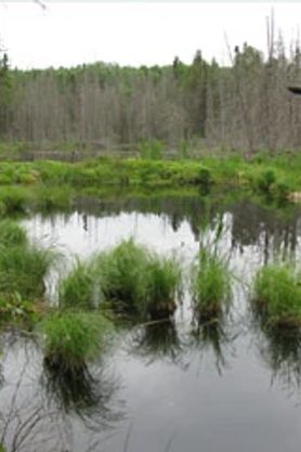 Photo by U.S. Forest Service
Wisconsin Slough features a unique wetland complex with a hard water spring pond surrounded by diverse sedge meadows and conifer swamps. The 5.6-acre spring pond has alkaline shallow water and a deep silt bottom. The springs originate near the base of a steep northeast-facing morainal slope and flow via a short outlet stream directly to the Brule River. The dominant aquatic plant in the spring pool is stonewort, a green Chara alga. Other species include sago pondweed and whitewater crowfoot. A narrow zone of emergent aquatic vegetation borders the pond with arrowhead, soft stem bulrush, cattail, and sweet gale. A small open wet meadow dominated by tussock sedge occurs on the pond's east end.
Also present are spike rushes, blue-joint grass, marsh fern, blue flag, spotted joe-pye weed, and lesser purple fringed orchid. Swamp conifers and alder flank the outlet stream and sedge meadow composed mainly of tamarack, black spruce, and white cedar. The moderately steep slopes east of the outlet stream are forested with jack pine, red pine, and white pine while trembling aspen and paper birch dominate the slopes west of the pond. Bird species include great blue heron, belted kingfisher, sharp-shinned hawk, raven, and golden-crowned kinglet. Wisconsin Slough is owned by the USDA Forest Service and was designated a State Natural Area in 1996.
Very few State Natural Areas have public facilities, but nearly all are open for various recreational activities as indicated below. Generally, there are no picnic areas, restrooms, or other developments. Parking lots or designated parking areas are noted on individual SNA pages and maps. Trails, if present, are typically undesignated footpaths. If a developed trail is present, it will normally be noted on the SNA map and/or under the Maps tab. A compass and topographic map or a GPS unit are useful tools for exploring larger, isolated SNAs.
The good majority of SNAs are isolated and have few or no facilities. Some SNAs have vehicle access lanes or parking lots, but their accessibility may vary depending on weather conditions. Parking lots and lanes are not plowed during winter. Hiking trails may be nonexistent or consist of undeveloped footpaths. A GPS unit or compass and a detailed topographic map are useful tools for exploring larger SNAs.
Non-DNR lands
Entrance fees: For non-DNR-owned SNAs, we are unaware of any vehicle or admission fees. However, please contact the landowner for more information.
Hunting and trapping
Other activities
Other allowable activities such as - but not limited to camping, geocaching and bicycling are determined by the landowner. Please contact them directly or visit their websites for details.
Location
Within the Chequamegon-Nicolet National Forest, Florence County. T41N-R15E, Section 34. 113 acres.
Driving directions
From the intersection of Highways 139 and 70 just west of Tipler, go north on 139 about 4.2 miles to the bridge over the Brule River. The area can be reached by canoeing downstream about 2.5 miles to the confluence with the slough's outlet stream. A short portage is necessary to clear the remains of an old road that formerly crossed the outlet stream.
The DNR's state natural areas program is comprised of lands owned by the state, private conservation organizations, municipalities, other governmental agencies, educational institutions and private individuals. While the majority of SNAs are open to the public, access may vary according to individual ownership policies. Public use restrictions may apply due to public safety, or to protect endangered or threatened species or unique natural features. Lands may be temporarily closed due to specific management activities. Users are encouraged to contact the landowner for more specific details.
The data shown on these maps have been obtained from various sources, and are of varying age, reliability, and resolution. The data may contain errors or omissions and should not be interpreted as a legal representation of legal ownership boundaries.
To create your custom map where you can zoom to a specific location, please use the DNR's mapping application.
Wisconsin Slough is owned by: U.S. Forest Service