Winchester Meadow
No. 661
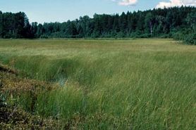 Photo by Eric Epstein
Winchester Meadow features a large, open sedge meadow-marsh situated in an extensive depression northwest of Lake Winneconne. The site boasts a diverse flora composed of woolly-fruit sedge, tussock sedge, blue-joint grass, marsh bellflower, blue-flag iris, marsh fern, marsh cinquefoil, and soft-stem bulrush. Shrub cover is mostly low with numerous species of willow, white meadowsweet, and bog birch. Some of the wetter areas contain small pools with at least three species of bladderwort present. The outer portions of the meadow are mostly tussock sedge with lake sedge and slender willow while the inner region is dominated by wire-leaved sedge mixed with lesser amounts of lesser panicled sedge, Buxbaum's sedge with patches of tussock sedge and large patches of cattails and soft-stem bulrush. The site is notable for its lack of invasives. Four rare birds are also present. Winchester Meadows is owned by the DNR. The site was purchased by the Northeast Wisconsin Land Trust and later transferred to the DNR. It was designated a State Natural Area in 2012.
Very few State Natural Areas have public facilities, but nearly all are open for various recreational activities as indicated below. Generally, there are no picnic areas, restrooms, or other developments. Parking lots or designated parking areas are noted on individual SNA pages and maps. Trails, if present, are typically undesignated footpaths. If a developed trail is present, it will normally be noted on the SNA map and/or under the Maps tab. A compass and topographic map or a GPS unit are useful tools for exploring larger, isolated SNAs.
The good majority of SNAs are isolated and have few or no facilities. Some SNAs have vehicle access lanes or parking lots, but their accessibility may vary depending on weather conditions. Parking lots and lanes are not plowed during winter. Hiking trails may be nonexistent or consist of undeveloped footpaths. A GPS unit or compass and a detailed topographic map are useful tools for exploring larger SNAs.
Entrance fees: Except for Parfrey's Glen, the Cambrian Outlook in the Dells of the Wisconsin River, SNAs within State Parks and some within State Forests, all other DNR-owned SNAs do not have any admission fees. For more information, see Wis. Admin. Code NR 45 [exit DNR]. For non-DNR-owned SNAs, we are unaware of any vehicle or admission fees. However, please contact the landowner for more information.
ALLOWABLE ACTIVITIES: DNR-OWNED LAND
The activities listed below are generally allowed on all DNR-owned SNA lands. Exceptions to this list of public uses, such as SNAs closed to hunting, are noted above and posted with signs on the property site.
- Hiking
- Fishing
- Cross country skiing
- Hunting
- Trapping
- Scientific research (permit required [PDF])
- Outdoor education
- Wild edibles (What is this?)
- Pets (Rules)
- Wildlife viewing
PROHIBITED ACTIVITIES: ALL SNAS
Although a handful of sites allow activities like primitive camping (e.g. Lower Chippewa River on sand bars) or horseback riding (e.g. S. Kettle Moraine), the activities listed below are generally prohibited on DNR-owned SNAs.
- Camping and campfires
- Collecting of animals (other than legally harvested species), non-edible fungi, rocks, minerals, fossils, archaeological artifacts, soil, downed wood, or any other natural material, alive or dead. Collecting for scientific research requires a permit issued by the DNR
- Collecting of plants including seeds, roots or other non-edible parts of herbaceous plants such as wildflowers or grasses
- Drones: Flying-related activities, including the use of drones, hang-gliders and model airplanes, are prohibited. Permission may be issued by the SNA Program for the use of drones for educational or research purposes.
- Geocaching
- Horseback riding
- Rock climbing
- Vehicles, including bicycles, ATVs, aircraft, and snowmobiles except on trails and roadways designated for their use
For rules governing state-owned SNAs and other state lands, please consult Chapter NR 45 Wis. Admin. Code [exit DNR].
Location
Within the Lower Wolf River Bottomlands Natural Resources Area, Winnebago County. T20N-R15E, Sections 19, 30. 444 acres.
Driving directions
From the intersection of Highway 150 and Steeple Hill Road in Winchester, go west on 150 for 2 miles, then south on County M for 0.5 miles, then southwest on County MM for 2.4 miles to a small easement access lane running north of the ditch. Walk west 0.15 miles into the site.
The data shown on these maps have been obtained from various sources, and are of varying age, reliability, and resolution. The data may contain errors or omissions and should not be interpreted as a legal representation of legal ownership boundaries.
To create your custom map where you can zoom to a specific location, please use the DNR's mapping application.
Winchester Meadow is owned by: Wisconsin DNR
MANAGEMENT OBJECTIVES AND PRESCRIPTIONS
- Control invasive exotics.
- Winter removal of shrubs along the edges to constrain woody encroachment on the open sedge meadow.
- Occasionally conduct a prescribed burn (approximately every 25 years) to rejuvenate the sedge meadow nutrient cycling system.
- Pursue opportunities to restore hydrology where feasible.