Wilson Lake
No. 436
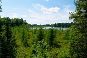 Photo by Josh Mayer
Wilson Lake features a high-quality mosaic of sedge meadow communities in association with Wilson Creek, Wilson Lake and Star Lake, and a northern dry-mesic forest situated on eskers. Several sedge community types are represented including sphagnum-dominated wire grass meadows, wire grass without sphagnum (poor fen), open sphagnum "lawns" without sedges, bluejoint grass-dominated meadows, and classic coarse sedge/cattail marsh. These communities grade into one another and are associated with both the stream and lake riparian areas. Some of the wiregrass areas approach a "fen-like" meadow with obvious groundwater influence. The state's special concern plant, the dragon's-mouth orchid occurs here in large numbers. Shrubs include sweet gale, bog rosemary, bog laurel, leather leaf, and blueberry. Other species include round-leaved sundew, pitcher plant, common bladderwort, rose pogonia, arrowgrass, cotton-grasses, bog-bean, and wild calla. Also present is a second-growth, fire-origin white pine and red pine growing on medium coarse sand eskers with small pockets of old-growth in several scattered locations near Star Lake.
There is a moderate shrub layer, little coarse woody debris, and limited snags. Many of these stands occur as islands surrounded by both lakes and sedge meadows. A small area of old-growth hemlock hardwoods occurs on the south shore of Star Lake. Water resources include Wilson Lake, Star Lake, and Wilson Creek. A 103-acre bog lake, Wilson Lake's fish population includes largemouth bass, perch, bluegill, pumpkinseed, bullhead, suckers, and minnows. The 104-acre Star Lake is also an acid bog lake and is the headwaters of Wilson Creek, which originates from two small feeder streams flowing into Star Lake and then flows south through the site into Wilson Lake and finally into Lost Land Lake on the Teal River System. Also included is Spring Lake, a small 11-acre lake with an outlet to Star Lake. It has some spring water sources. This wide variety of sedge meadow communities in association with high-quality, wilderness-like lakes and streams, and upland second-growth white and red pine make this a unique site. Wilson Lake is owned by the U.S. Forest Service and was designated a State Natural Area in 2007. This site is also recognized by the Forest Service as an established Research Natural Area.
Very few State Natural Areas have public facilities, but nearly all are open for various recreational activities as indicated below. Generally, there are no picnic areas, restrooms, or other developments. Parking lots or designated parking areas are noted on individual SNA pages and maps. Trails, if present, are typically undesignated footpaths. If a developed trail is present, it will normally be noted on the SNA map and/or under the Maps tab. A compass and topographic map or a GPS unit are useful tools for exploring larger, isolated SNAs.
The good majority of SNAs are isolated and have few or no facilities. Some SNAs have vehicle access lanes or parking lots, but their accessibility may vary depending on weather conditions. Parking lots and lanes are not plowed during winter. Hiking trails may be nonexistent or consist of undeveloped footpaths. A GPS unit or compass and a detailed topographic map are useful tools for exploring larger SNAs.
Non-DNR lands
Entrance fees: For non-DNR-owned SNAs, we are unaware of any vehicle or admission fees. However, please contact the landowner for more information.
Hunting and trapping
Other activities
Other allowable activities such as - but not limited to camping, geocaching and bicycling are determined by the landowner. Please contact them directly or visit their websites for details.
Location
Within the Chequamegon-Nicolet National Forest, Sawyer and Bayfield Counties. T42N-R6W, Sections 32, 33; T43N-R6W, Sections 8, 9, 16, 17. 1,060 acres.
Driving directions
The site is located 12 miles west of Clam Lake Wisconsin on the Sawyer/Bayfield county line. Access is best taking County M west from Clam Lake for 11 miles, then south on FR 203 for 3 miles, then west on FR 206 for one mile, then west on FR 658 for one mile to Wilson Lake (bear left at the intersection). A canoe is recommended for further access.
The DNR's state natural areas program is comprised of lands owned by the state, private conservation organizations, municipalities, other governmental agencies, educational institutions and private individuals. While the majority of SNAs are open to the public, access may vary according to individual ownership policies. Public use restrictions may apply due to public safety, or to protect endangered or threatened species or unique natural features. Lands may be temporarily closed due to specific management activities. Users are encouraged to contact the landowner for more specific details.
The data shown on these maps have been obtained from various sources, and are of varying age, reliability, and resolution. The data may contain errors or omissions and should not be interpreted as a legal representation of legal ownership boundaries.
To create your custom map where you can zoom to a specific location, please use the DNR's mapping application.
Wilson Lake is owned by: U.S. Forest Service