Whitefish Dunes
No. 175
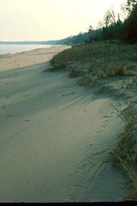 Photo by Thomas A. Meyer/DNR
Whitefish Dunes State Natural Area preserves the largest and most significant Great Lakes dunescape in Wisconsin. The complex of active and stabilized dunes protected by Whitefish Bay along the Lake Michigan coast contains a rich flora particularly adapted to this dynamic habitat. All stages of succession, from the open beach through the northern mesic and wet-mesic forest, are represented here. The lakeside fore dune is open, sandy and vegetated with common milkweed, beach wormwood, beach pea, lyrate rock cress and several beach grasses. The backside of the fore dune is forested with white birch, balsam fir, and white cedar and contains a ground cover of abundant Canada yew. The dunes farther from the lake are more stabilized and heavily wooded with a northern mesic forest of sugar maple, large-toothed aspen, eastern hemlock, and American beech. Also present is a small bog lake with associated sedge meadow and frontage on Clark Lake, a bay mouth bar lake. Common nesting birds include red-eyed vireo, veery, black-throated green and Canada warblers, American redstart, and eastern wood pewee. Whitefish Dunes is owned by the DNR and was designated a State Natural Area in 1980.
Very few State Natural Areas have public facilities, but nearly all are open for various recreational activities as indicated below. Generally, there are no picnic areas, restrooms, or other developments. Parking lots or designated parking areas are noted on individual SNA pages and maps. Trails, if present, are typically undesignated footpaths. If a developed trail is present, it will normally be noted on the SNA map and/or under the Maps tab. A compass and topographic map or a GPS unit are useful tools for exploring larger, isolated SNAs.
The good majority of SNAs are isolated and have few or no facilities. Some SNAs have vehicle access lanes or parking lots, but their accessibility may vary depending on weather conditions. Parking lots and lanes are not plowed during winter. Hiking trails may be nonexistent or consist of undeveloped footpaths. A GPS unit or compass and a detailed topographic map are useful tools for exploring larger SNAs.
Entrance fees: Except for Parfrey's Glen, the Cambrian Outlook in the Dells of the Wisconsin River, SNAs within State Parks and some within State Forests, all other DNR-owned SNAs do not have any admission fees. For more information, see Wis. Admin. Code NR 45 [exit DNR]. For non-DNR-owned SNAs, we are unaware of any vehicle or admission fees. However, please contact the landowner for more information.
ALLOWABLE ACTIVITIES: DNR-OWNED LAND
In general, the activities listed below are allowed on all DNR-owned SNA lands. Exceptions to this list of public uses, such as SNAs closed to hunting, are noted under the "Access" tab above and posted with signs on site.
- Hiking
- Fishing
- Cross country skiing
- Hunting
- Trapping
- Scientific research (permit required [PDF])
- Outdoor education
- Wild edibles (What is this?)
- Pets (Rules)
- Wildlife viewing
PROHIBITED ACTIVITIES: ALL SNAS
Although a handful of sites allow activities like primitive camping (e.g. Lower Chippewa River on sand bars) or horseback riding (e.g. S. Kettle Moraine), the activities listed below are generally prohibited on DNR-owned SNAs.
- Camping and campfires
- Collecting of animals (other than legally harvested species), non-edible fungi, rocks, minerals, fossils, archaeological artifacts, soil, downed wood, or any other natural material, alive or dead. Collecting for scientific research requires a permit issued by the DNR
- Collecting of plants including seeds, roots or other non-edible parts of herbaceous plants such as wildflowers or grasses
- Drones: Flying-related activities, including the use of drones, hang-gliders and model airplanes, are prohibited. Permission may be issued by the SNA Program for the use of drones for educational or research purposes.
- Geocaching
- Horseback riding
- Rock climbing
- Vehicles, including bicycles, ATVs, aircraft, and snowmobiles except on trails and roadways designated for their use
For rules governing state-owned SNAs and other state lands, please consult Chapter NR 45 Wis. Admin. Code [exit DNR].
Location
Within Whitefish Dunes State Park, Door County. T28N-R27E, Sections 2, 3, 10. 256 acres.
Driving directions
From the intersection of State Highway 57 and County Highway T in Valmy, go north on 57 for 1.1 miles, then east on Clark Lake Road (County Highway WD) for 2.1 miles to the entrance of Whitefish Dunes State Park. Continue 1.5 miles to the park office and parking area. Several hiking trails lead south into the dunes. A Wisconsin State Park sticker must be displayed on all vehicles entering the park.
The DNR's state natural areas program is comprised of lands owned by the state, private conservation organizations, municipalities, other governmental agencies, educational institutions and private individuals. While the majority of SNAs are open to the public, access may vary according to individual ownership policies. Public use restrictions may apply due to public safety, or to protect endangered or threatened species or unique natural features. Lands may be temporarily closed due to specific management activities. Users are encouraged to contact the landowner for more specific details.
The data shown on these maps have been obtained from various sources, and are of varying age, reliability, and resolution. The data may contain errors or omissions and should not be interpreted as a legal representation of legal ownership boundaries.
To create your custom map where you can zoom to a specific location, please use the DNR's mapping application.
Whitefish Dunes is owned by: Wisconsin DNR