Waupun Park Maple Forest
No. 51
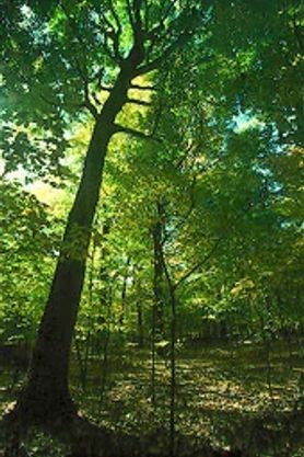 Photo by Thomas A. Meyer/DNR
Waupun Park Maple Forest features an outstanding old-growth remnant of southern mesic forest – a deciduous community type that originally covered an estimated 3.4 million acres in southern Wisconsin. The nearly level site is underlain by rich silt loam soils over calcareous till that supports many mature trees well over 2 feet in diameter. Sugar maple is the dominant canopy species, but there is a diversity of other large trees including red oak, white oak, basswood, white ash, and black walnut.
Smaller mid-canopy trees are also present including slippery elm, eastern hop-hornbeam, black cherry, and bitternut hickory. There is abundant reproduction of sugar maple and a striking absence of shrubs in the understory. The northwestern portion of the site is drier and contains a higher amount of oaks including black oak. There is a diversity of herbaceous plants with a rich mixture of spring flowers including white and red baneberry, bloodroot, blue cohosh, sharp-lobed hepatica, jack-in-the-pulpit, may-apple, phlox, spring beauty, toothwort, large-flowered trillium, white trout-lily, violets, Virginia water-leaf, and wood anemone. Waupun Park Maple Forest is owned by Fond du Lac County and was designated a State Natural Area in 1967.
Very few State Natural Areas have public facilities, but nearly all are open for various recreational activities as indicated below. Generally, there are no picnic areas, restrooms, or other developments. Parking lots or designated parking areas are noted on individual SNA pages and maps. Trails, if present, are typically undesignated footpaths. If a developed trail is present, it will normally be noted on the SNA map and/or under the Maps tab. A compass and topographic map or a GPS unit are useful tools for exploring larger, isolated SNAs.
The good majority of SNAs are isolated and have few or no facilities. Some SNAs have vehicle access lanes or parking lots, but their accessibility may vary depending on weather conditions. Parking lots and lanes are not plowed during winter. Hiking trails may be nonexistent or consist of undeveloped footpaths. A GPS unit or compass and a detailed topographic map are useful tools for exploring larger SNAs.
Non-DNR lands
Entrance fees: For non-DNR-owned SNAs, we are unaware of any vehicle or admission fees. However, please contact the landowner for more information.
Hunting and trapping
Other activities
Other allowable activities such as - but not limited to camping, geocaching and bicycling are determined by the landowner. Please contact them directly or visit their websites for details.
Location
Within Waupun County Park, Fond du Lac County. T14N-R15E, Section 31 NE¼NE¼. 40 acres.
Driving directions
From the intersection of State Highway 49 and County Highway MMM on the west side of Waupun, go north on MMM 0.8 miles into Waupun County Park to a parking area north of the road. The natural area lies east of the campground. A trail winds through the woods.
The DNR's state natural areas program is comprised of lands owned by the state, private conservation organizations, municipalities, other governmental agencies, educational institutions and private individuals. While the majority of SNAs are open to the public, access may vary according to individual ownership policies. Public use restrictions may apply due to public safety, or to protect endangered or threatened species or unique natural features. Lands may be temporarily closed due to specific management activities. Users are encouraged to contact the landowner for more specific details.
The data shown on these maps have been obtained from various sources, and are of varying age, reliability, and resolution. The data may contain errors or omissions and should not be interpreted as a legal representation of legal ownership boundaries.
To create your custom map where you can zoom to a specific location, please use the DNR's mapping application.
Waupun Park Maple Forest is owned by: Fond du Lac County