Waupee Lake Swamp
No. 483
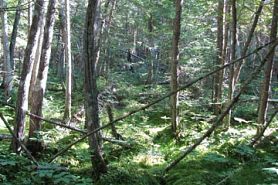 Photo by U.S. Forest Service
The Waupee Lake complex is an arm of the much more extensive Peshtigo Brook Swamp to the south and east of the National Forest. The entire complex is within the basin of glacial Lake Oconto and is underlain by a nearly level bed of sand. Relief is provided by wind and water-worked dunes and occasional rock outcrops. Most of the swamp surrounding Waupee Lake is dominated by northern white cedar. Associated trees include tamarack, black spruce, balsam fir, black ash, red maple, paper birch, yellow birch, and eastern hemlock. A few scattered super-canopy white pine and red pine are present. The characteristic understory includes bunchberry, creeping snowberry, three-leaved goldthread, Labrador-tea, false Solomon's seal, gaywings, and cinnamon fern. Contained within the SNA is the headwaters for Little Waupee Creek, which flows southwest into the North Branch of the Oconto River. Waupee Lake, a 34-acre wild lake, has a high concentration of rare plants in the conifer swamps that surround the lake.
Around the lake are open wetlands dominated by sedges, bulrushes, blue-joint grass, and other grasses. Common species include marsh fern, marsh cinquefoil, blue flag, swamp betony, and poison sumac. Emergent and floating-leaved vegetation is present along the lake margins and across portions of its surface. Species include soft-stem bulrush, cat-tail, common reed, pond lilies, and white water lily. Overall, the swamps of this area have moderate plant species richness except around Waupee Lake, which appears from calcareous groundwater inputs giving it an unusually high number of rare plant species. The surrounding uplands support sugar maple, quaking aspen, balsam fir, and eastern hemlock. East of the lake and swamp are slightly higher areas dominated by hemlock and white pine. Waupee Lake Swamp is owned by the U.S. Forest Service and was designated a State Natural Area in 2007. This site is also recognized by the Forest Service as an established Research Natural Area.
Very few State Natural Areas have public facilities, but nearly all are open for a variety of recreational activities as indicated below. Generally, there are no picnic areas, restrooms, or other developments. Parking lots or designated parking areas are noted on individual SNA pages and maps. Trails, if present, are typically undesignated footpaths. If a developed trail is present, it will normally be noted on the SNA map and/or under the Maps tab. A compass and topographic map or a GPS unit are useful tools for exploring larger, isolated SNAs.
The good majority of SNAs are isolated and have few or no facilities. Some SNAs have vehicle access lanes or parking lots, but their accessibility may vary depending on weather conditions. Parking lots and lanes are not plowed during winter. Hiking trails may be nonexistent or consist of undeveloped footpaths. A GPS unit or compass and a detailed topographic map are useful tools for exploring larger SNAs.
Non-DNR lands
Entrance fees: For non-DNR-owned SNAs, we are unaware of any vehicle or admission fees. However, please contact the landowner for more information.
Hunting and trapping
Other activities
Other allowable activities such as - but not limited to camping, geocaching and bicycling are determined by the landowner. Please contact them directly or visit their websites for details.
Location
Within the Chequamegon-Nicolet National Forest. Oconto County. T31N-R17E, Sections 1, 2, 3, 10, 11, 12, 14, 15, 22, 23. T32-R17E, Section 34, 35, 36. 2,886 acres.
Driving directions
Access is by County Road W, Riverview Road, and an unimproved road. From Mountain, go east on County W for 4.5 miles, then east on Riverview Road (FR 2107) for 2.4 miles to a point where the road turns north. Turn south on an unimproved road and continue south for about 0.5 miles. Waupee Lake lies a short distance to the east.
The DNR's state natural areas program is comprised of lands owned by the state, private conservation organizations, municipalities, other governmental agencies, educational institutions and private individuals. While the majority of SNAs are open to the public, access may vary according to individual ownership policies. Public use restrictions may apply due to public safety, or to protect endangered or threatened species or unique natural features. Lands may be temporarily closed due to specific management activities. Users are encouraged to contact the landowner for more specific details.
The data shown on these maps have been obtained from various sources, and are of varying age, reliability, and resolution. The data may contain errors or omissions and should not be interpreted as a legal representation of legal ownership boundaries.
To create your custom map where you can zoom to a specific location, please use the DNR's mapping application.
Waupee Lake Swamp is owned by: U.S. Forest Service