Waubesa Wetlands
No. 114
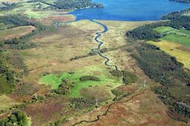 Photo by Cal Dewitt
Located in an old lobe of Lake Waubesa along its southwest shore, Waubesa Wetlands is one of the highest quality and most diverse wetlands remaining in southern Wisconsin. Nine major springs and numerous smaller ones located within and around the area provide the wetland with an abundance of high-quality water. The extensive wetlands and high quality of the water contribute significantly to the water quality of Lake Waubesa. Two inlet streams are also present - Murphy Creek and Swan Creek. Peat deposits - up to 95' deep in places - underlie a mix of sedge meadow, fen, and shrub-carr communities. The sedge meadow is a complex of different species that vary in abundance and structure in response to the complex hydrological system.
Other parts of the site feature quaking sedge mats, calcareous fens, springs and streams with submerged aquatics, and deep spring cones lined with filamentous algae and purple-colored bacteria. The carbonate-rich fens feature numerous species including grass-of-Parnassus, Riddell's goldenrod, northern bog aster, lesser fringed gentian, and sage willow. Other abundant wetland species are common lake sedge, tussock sedge, American woolly-fruited sedge, common bur-reed, swamp loosestrife, American water horehound, blue-joint grass, and numerous asters. Bird life is diverse and includes sandhill crane, green heron, marsh and sedge wren, blue-winged teal, green-winged teal, and willow flycatcher. Waubesa Wetlands is owned by the DNR, The Nature Conservancy, and Dane County. It was designated a State Natural Area in 1974.
Very few State Natural Areas have public facilities, but nearly all are open for various recreational activities as indicated below. Generally, there are no picnic areas, restrooms, or other developments. Parking lots or designated parking areas are noted on individual SNA pages and maps. Trails, if present, are typically undesignated footpaths. If a developed trail is present, it will normally be noted on the SNA map and/or under the Maps tab. A compass and topographic map or a GPS unit are useful tools for exploring larger, isolated SNAs.
The good majority of SNAs are isolated and have few or no facilities. Some SNAs have vehicle access lanes or parking lots, but their accessibility may vary depending on weather conditions. Parking lots and lanes are not plowed during winter. Hiking trails may be nonexistent or consist of undeveloped footpaths. A GPS unit or compass and a detailed topographic map are useful tools for exploring larger SNAs.
Hunting and trapping
Allowable activities: DNR-owned land
The activities listed below are generally allowed on all DNR-owned SNA lands. Exceptions to this list of public uses, such as SNAs closed to hunting, are noted above and posted with signs on the property site.
- Hiking
- Fishing
- Cross country skiing
- Hunting
- Trapping
- Scientific research (permit required [PDF])
- Outdoor education
- Wild edibles (What is this?)
- Pets (Rules)
- Wildlife viewing
Prohibited activities: all SNAs
- Camping and campfires
- Collecting of animals (other than legally harvested species), non-edible fungi, rocks, minerals, fossils, archaeological artifacts, soil, downed wood, or any other natural material, alive or dead. Collecting for scientific research requires a permit issued by the DNR
- Collecting of plants including seeds, roots or other non-edible parts of herbaceous plants such as wildflowers or grasses
- Geocaching
- Horseback riding
- Rock climbing
- Vehicles, including bicycles, ATVs, aircraft, and snowmobiles except on trails and roadways designated for their use
For rules governing state-owned SNAs and other state lands, please consult Chapter NR 45 Wis. Admin. Code [exit DNR].
Location
Dane County. T6N-R10E, Section 7, 8, 17, 18. 566 acres.
Driving directions
From the intersection of U.S. Highway 14 and County Highway MM south of Madison, go south on MM for 1.3 miles, then east on Goodland Park Road for 0.9 miles, then south on Lalor Road for 0.8 miles to a parking area east of the road. The parking lot and adjacent access lane are owned by The Nature Conservancy. Visitors (no dogs) are welcome to use both to access DNR lands. An additional DNR-owned walk-in access lane is further South on Lalor Rd .5 miles from the parking lot. Canoe access is via Lake Waubesa from the canoe landing at Goodland County Park at the end of Goodland Park Road.
The DNR's state natural areas program is comprised of lands owned by the state, private conservation organizations, municipalities, other governmental agencies, educational institutions and private individuals. While the majority of SNAs are open to the public, access may vary according to individual ownership policies. Public use restrictions may apply due to public safety, or to protect endangered or threatened species or unique natural features. Lands may be temporarily closed due to specific management activities. Users are encouraged to contact the landowner for more specific details.
The data shown on these maps have been obtained from various sources, and are of varying age, reliability, and resolution. The data may contain errors or omissions and should not be interpreted as a legal representation of legal ownership boundaries.
To create your custom map where you can zoom to a specific location, please use the DNR's mapping application.
Waubesa Wetlands is owned by: The Nature Conservancy, Wisconsin DNR, Dane County and Private