Waterloo Quartzite Outcrops
No. 605
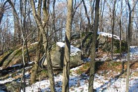
Waterloo Quartzite Outcrops consist of two separate geological features of Precambrian red quartzite and Paleozoic conglomerate rock. The southernmost outcrop, Stony Island, is a 23-acre quartzite island in the Crawfish and Maunesha River floodplain. Rock is abundant on the surface. The elevation from the floodplain to the top of the island is 40 feet with 5-30% slopes. A variety of hardwood species grow here with white oak, red oak, shagbark hickory, and hackberry common. Some of these are open-grown and over two feet in diameter. Other species include bur oak, black cherry, ash, and basswood. Spring ephemerals are abundant and pale corydalis, a plant of cliff and savanna habitats, grows on the rocks.
To the north, in the Waterloo Wildlife Area is a 24-acre island of Pella silty clay loam and abundant quartzite outcrops. The outcrops are comprised of quartzite breccia, a rough rock comprised of very angular fragments of gray and red quartzite within a matrix of white quartz. This same rock occurs in at least four different localities in the Baraboo Hills and was formerly a monadnock, an isolated knob or ridge, during Precambrian times. The breccia has much geological value since the other minerals besides quartz are of great interest for isotopic dating of the breccia along with estimating the temperature of its formation. The exact cause of the breakage, or brecciation, of the quartzite, is still controversial. The woods contain large white, bur, and red oaks, shagbark hickory, ash, and basswood. Saplings include ironwood, hackberry, yellow bud hickory, and hawthorn. The ground layer is dominated by wild leek. Waterloo Quartzite Outcrops is owned by the DNR and was designated a State Natural Area in 2010.
Very few State Natural Areas have public facilities, but nearly all are open for various recreational activities as indicated below. Generally, there are no picnic areas, restrooms, or other developments. Parking lots or designated parking areas are noted on individual SNA pages and maps. Trails, if present, are typically undesignated footpaths. If a developed trail is present, it will normally be noted on the SNA map and/or under the Maps tab. A compass and topographic map or a GPS unit are useful tools for exploring larger, isolated SNAs.
The good majority of SNAs are isolated and have few or no facilities. Some SNAs have vehicle access lanes or parking lots, but their accessibility may vary depending on weather conditions. Parking lots and lanes are not plowed during winter. Hiking trails may be nonexistent or consist of undeveloped footpaths. A GPS unit or compass and a detailed topographic map are useful tools for exploring larger SNAs.
Entrance fees: Except for Parfrey's Glen, the Cambrian Outlook in the Dells of the Wisconsin River, SNAs within State Parks and some within State Forests, all other DNR-owned SNAs do not have any admission fees. For more information, see Wis. Admin. Code NR 45[exit DNR]. For non-DNR-owned SNAs, we are unaware of any vehicle or admission fees. However, please contact the landowner for more information.
ALLOWABLE ACTIVITIES: DNR-OWNED LAND
The activities listed below are generally allowed on all DNR-owned SNA lands. Exceptions to this list of public uses, such as SNAs closed to hunting, are noted above and posted with signs on the property site.
- Hiking
- Fishing
- Cross country skiing
- Hunting
- Trapping
- Scientific research (permit required [PDF])
- Outdoor education
- Wild edibles (What is this?)
- Pets (Rules)
- Wildlife viewing
PROHIBITED ACTIVITIES: ALL SNAS
Although a handful of sites allow activities like primitive camping (e.g. Lower Chippewa River on sand bars) or horseback riding (e.g. S. Kettle Moraine), the activities listed below are generally prohibited on DNR-owned SNAs.
- Camping and campfires
- Collecting of animals (other than legally harvested species), non-edible fungi, rocks, minerals, fossils, archaeological artifacts, soil, downed wood, or any other natural material, alive or dead. Collecting for scientific research requires a permit issued by the DNR
- Collecting of plants including seeds, roots or other non-edible parts of herbaceous plants such as wildflowers or grasses
- Drones: Flying-related activities, including the use of drones, hang-gliders and model airplanes, are prohibited. Permission may be issued by the SNA Program for the use of drones for educational or research purposes.
- Geocaching
- Horseback riding
- Rock climbing
- Vehicles, including bicycles, ATVs, aircraft, and snowmobiles except on trails and roadways designated for their use
For rules governing state-owned SNAs and other state lands, please consult Chapter NR 45 Wis. Admin. Code [exit DNR].
Location
Northern Unit within Mud Lake Wildlife Area; Southern Unit within Waterloo Wildlife Area, Dodge County. T9N-R13E, Section 27 and T9N-R14E, Section 3. 47 acres.
Driving directions
Southern Unit: access is by boat from a boat launch on Hubbleton Road. From the intersection of State Highway 19 and 89 in Waterloo, go east on 19 for 2.6 miles, then north on Hubbleton Road for 1.5 miles to a parking area and boat launch. Northern Unit: from the intersection of County J and G in Reeseville, go south on G for 2 miles, then south and east on Mud Lake Road for 1 mile. The natural area lies 0.3 miles east. Access is dependent on water levels. A boat will be needed during high water.
The DNR's state natural areas program is comprised of lands owned by the state, private conservation organizations, municipalities, other governmental agencies, educational institutions and private individuals. While the majority of SNAs are open to the public, access may vary according to individual ownership policies. Public use restrictions may apply due to public safety, or to protect endangered or threatened species or unique natural features. Lands may be temporarily closed due to specific management activities. Users are encouraged to contact the landowner for more specific details.
The data shown on these maps have been obtained from various sources, and are of varying age, reliability, and resolution. The data may contain errors or omissions and should not be interpreted as a legal representation of legal ownership boundaries.
To create your custom map where you can zoom to a specific location, please use the DNR's mapping application.
Waterloo Quartzite Outcrops is owned by: Wisconsin DNR
Management objectives and prescriptions
- Conduct fall or early spring prescribed burns.
- Remove buckthorn and honeysuckle
- Remove a small wooden building and about 800 feet of fence (Mud Lake Unit)