Washburn Marsh
No. 192
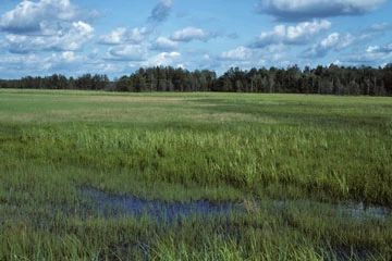
Photo by Eric Epstein
Situated in a large wetland basin, Washburn Marsh is an undisturbed wetland that includes expanses dominated by sedges and sphagnum moss, black spruce-tamarack swamp and some white and red pine in the surrounding area. The southern and central parts are dominated by sphagnum moss and wire-leaved sedges. Also important are cranberry, blue-joint grass, and steeplebush. pitcher plant, sundew, and lance-leaved violet. Bog birch is the predominant shrub. Towards the northeast the dominance shifts to broad-leaved sedges, Labrador-tea, and cotton grass, with associated black chokeberry, three-way sedge, and rose pogonia.
Swamp conifers are encroaching on open areas with scattered conifer islands of Jack pine, white pine, black spruce, and tamarack. The northwest portion of the site contains an acid conifer swamp of black spruce and tamarack. Black chokeberry and huckleberry dominate the tall, dense shrub layer with common winterberry, mountain holly, and alders. Other species include swamp dewberry, cinnamon fern, and few-seeded sedge. The marsh edge is entirely forested by red maple, oak, and white pine and red pine. Sandhill cranes have been seen here. Resident bird species include Nashville warbler, verry, alder flycatcher, and white-throated sparrow. Some mossing has occurred along the marsh edges, but the disturbed area is not extensive. Washburn Marsh is owned by the DNR and was designated a State Natural Area in 1983.
Very few State Natural Areas have public facilities, but nearly all are open for various recreational activities as indicated below. Generally, there are no picnic areas, restrooms, or other developments. Parking lots or designated parking areas are noted on individual SNA pages and maps. If a developed trail is present, it will normally be noted on the SNA map and/or under the Maps tab. A compass and topographic map or a GPS unit are useful tools for exploring larger, isolated SNAs.
The good majority of SNAs are isolated and have few or no facilities. Some SNAs have vehicle access lanes or parking lots, but their accessibility may vary depending on weather conditions. Parking lots and lanes are not plowed during winter. Hiking trails may be nonexistent or consist of undeveloped footpaths. A GPS unit or compass and a detailed topographic map are useful tools for exploring larger SNAs.
Entrance fees: Except for Parfrey's Glen, the Cambrian Outlook in the Dells of the Wisconsin River, SNAs within State Parks and some within State Forests, all other DNR-owned SNAs do not have any admission fees. For more information, see Wis. Admin. Code NR 45 [exit DNR]. For non-DNR-owned SNAs, we are unaware of any vehicle or admission fees. However, please contact the landowner for more information.
Allowable activities: DNR-owned land
The activities listed below are generally allowed on all DNR-owned SNA lands. Exceptions to this list of public uses, such as SNAs closed to hunting, are noted above and posted with signs on the property site.
- Hiking
- Fishing
- Cross country skiing
- Hunting
- Trapping
- Scientific research (permit required [PDF])
- Outdoor education
- Wild edibles (What is this?)
- Pets (Rules)
- Wildlife viewing
Prohibited activities: all SNAs
Although a handful of sites allow activities like primitive camping (e.g. Lower Chippewa River on sand bars) or horseback riding (e.g. S. Kettle Moraine), the activities listed below are generally prohibited on DNR-owned SNAs.
- Camping and campfires
- Collecting of animals (other than legally harvested species), non-edible fungi, rocks, minerals, fossils, archaeological artifacts, soil, downed wood, or any other natural material, alive or dead.
- Collecting for scientific research requires a permit issued by the DNR
- Collecting of plants including seeds, roots or other non-edible parts of herbaceous plants such as wildflowers or grasses
- Drones: Flying-related activities, including the use of drones, hang-gliders and model airplanes, are prohibited. Permission may be issued by the SNA Program for the use of drones for educational or research purposes
- Geocaching
- Horseback riding
- Rock climbing
- Vehicles, including bicycles, ATVs, aircraft, and snowmobiles except on trails and roadways designated for their use.
For rules governing state-owned SNAs and other state lands, please consult Chapter NR 45 Wis. Admin. Code [exit DNR].
Location
Within the Black River State Forest, Jackson County. T20N-R2W, Sections 4, 5. T21N-R2W, Sections 32, 33. 604 acres.
Driving directions
From the junction of I-94 and County O in Millston, go east on O for 0.3 miles, then north on North Settlement Road for 0.6 miles, then southwest and north on Stanton Creek Road for 3.3 miles, then north about 1 mile on an access road. Walk east into the natural area. Or from I-90 and O, go northeast on North Settlement Road 2.65 miles, then northwest on a snowmobile trail about 1.5 miles to the east side of the natural area. Or access the north side via a snowmobile trail just east of Wildcat Flowage off Kling Road.
The DNR's state natural areas program is comprised of lands owned by the state, private conservation organizations, municipalities, other governmental agencies, educational institutions and private individuals. While the majority of SNAs are open to the public, access may vary according to individual ownership policies. Public use restrictions may apply due to public safety, or to protect endangered or threatened species or unique natural features. Lands may be temporarily closed due to specific management activities.
Users are encouraged to contact the landowner for more specific details. The data shown on these maps have been obtained from various sources, and are of varying age, reliability, and resolution. The data may contain errors or omissions and should not be interpreted as a legal representation of legal ownership boundaries. To create your custom map where you can zoom to a specific location, please use the DNR's Mapping Application.
Washburn Marsh is owned by: Wisconsin DNR