Wabikon Lake
No. 447
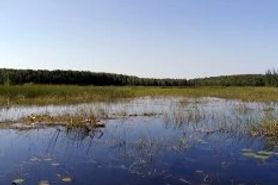 Photo by U.S. Forest Service
Of primary significance at Wabikon Lake are the extensive high-quality forested wetlands with several rare plant populations. Along the shore of Wabikon Lake is an old-growth hemlock stand with occasional sugar maple, yellow birch, and white cedar present. The hemlock ranges from pole size to at least 34 inches in diameter. The dense shade of the hemlock results in a very sparse, nearly absent, ground layer. Extensive swamp forests in the northeast quarter occupy an area that was formerly part of Wabikon Lake and is partly underlain by lacustrine sands. These stands vary in quality and composition, ranging from the excellent old-growth white-cedar in the east-central part of the complex to a large "hybrid" swamp containing both black spruce bog and white-cedar swamp components in the northeast quarter.
Black ash is common to dominant in some stands, with red maple and yellow birch also common. The shallow waters along the shores of both Wabikon and Riley Lakes contain extensive high-quality emergent aquatic communities. The bulrushes, cattails, and large wild-rice patches attract numerous waterfowl. Water-willow is abundant in a floating sedge mat on Riley Lake as well as along the channel connecting the two lakes. In the western half of the complex are mixed northern hardwood forests on hummocky terrain dominated by sugar maple and basswood. White ash is prominent in some stands, while yellow birch is scattered throughout. Black cherry, butternut, red oak, and mature aspen are occasional to frequent. American elm was formerly an important component but now survives only as saplings due to the introduction of Dutch elm disease.
The understory varies from open to dense, with thick stands of sugar maple and white ash saplings occurring in places. Eastern hop-hornbeam is fairly common. Common ground layer species include maidenhair fern, large-flowered bellwort, plantain-leaved sedge, and American spikenard. A prominent esker running discontinuously north to south through the center of the complex supports a mix of CCC-planted white spruce, young aspen stands, fir, and mixed hardwoods. Soils here are rockier and appear less fertile than those to the west. Ground layers are also not as rich and are quite sparse under the dense white spruce. A large recent blowdown caught the north edge of the complex and cut an approximately 1/8 mile-wide swath in the forest, reaching the shore of Wabikon Lake and perhaps beyond. The portion of the blowdown on FS land is unsalvaged and exhibits excellent hardwood regeneration, as compared to the salvaged private land to the north. Wabikon Lake is owned by the US Forest Service and was designated a State Natural Area in 2007.
Very few State Natural Areas have public facilities, but nearly all are open for various recreational activities as indicated below. Generally, there are no picnic areas, restrooms, or other developments. Parking lots or designated parking areas are noted on individual SNA pages and maps. If a developed trail is present, it will normally be noted on the SNA map and/or under the Maps tab. A compass and topographic map or a GPS unit are useful tools for exploring larger, isolated SNAs.
The good majority of SNAs are isolated and have few or no facilities. Some SNAs have vehicle access lanes or parking lots, but their accessibility may vary depending on weather conditions. Parking lots and lanes are not plowed during winter. Hiking trails may be nonexistent or consist of undeveloped footpaths. A GPS unit or compass and a detailed topographic map are useful tools for exploring larger SNAs.
Non-DNR lands
Entrance fees: For non-DNR-owned SNAs, we are unaware of any vehicle or admission fees. However, please contact the landowner for more information.
Hunting and trapping
Other activities
Other allowable activities such as - but not limited to camping, geocaching and bicycling are determined by the landowner. Please contact them directly or visit their websites for details.
Location
Located within the Chequamegon-Nicolet National Forest. Forest County. T35N-R14E, Sections 6, 18; T36N-R14E, Section 31. 1,105 acres.
Driving directions
From the junction of Highways 8 and 32 in Laona, go west on 8-32 for about 5.4 miles, then south on Potowatomi Road for 0.8 miles to an unnamed forest road. Turn south and go 0.2 miles to an FS gate at the beginning of FS 2632. This is the north boundary of the site; FS 2632 runs along the west edge of the north half of the site.
The DNR's state natural areas program is comprised of lands owned by the state, private conservation organizations, municipalities, other governmental agencies, educational institutions and private individuals. While the majority of SNAs are open to the public, access may vary according to individual ownership policies. Public use restrictions may apply due to public safety, or to protect endangered or threatened species or unique natural features. Lands may be temporarily closed due to specific management activities. Users are encouraged to contact the landowner for more specific details.
The data shown on these maps have been obtained from various sources, and are of varying age, reliability, and resolution. The data may contain errors or omissions and should not be interpreted as a legal representation of legal ownership boundaries.
To create your custom map where you can zoom to a specific location, please use the DNR's mapping application.
Wabikon Lake is owned by: U.S. Forest Service