Vosse Coulee
No. 627
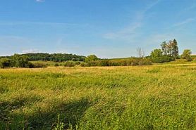 Photo by Aaron Carlson
Vosse Coulee is a botanically rich site located along the eastern edge of the sandstone-influenced Driftless Area. The area harbors a diverse wet prairie, a small high-quality dry prairie, an oak opening restoration site, and a high-quality mesic prairie undergoing restoration. Wet prairies now encompass less than 500 acres statewide and are of high conservation value while oak openings and mesic prairie have been nearly extirpated and require committed restoration efforts. Although common historically, mesic prairies are extremely rare today due to their high productivity for agricultural use. The wet prairie supports numerous sedges and a good variety of showy forbs.
Plants include Joe-pye weed, boneset, Michigan lily, swamp milkweed, culver's-root, cup plant, marsh bellflower, turtlehead, water-hemlock, swamp thistle, grass-leaved goldenrod, flowering spurge, ox-eye sunflower, bottle gentian, purple meadow-rue, golden Alexander, and cowbane. White meadowsweet is fairly common. Vosse Coulee Creek is Class 2 trout water, supporting both Brook and Brown trout. The stream is flanked by alders. A few small silver maple, cottonwoods, and box elder are also present. The creek is a tributary of the Trempealeau River and both the stream and spring runs provide additional diversity to the site. Vosse Coulee is owned by the DNR and was designated a State Natural Area in 2010.
Very few State Natural Areas have public facilities, but nearly all are open for various recreational activities as indicated below. Generally, there are no picnic areas, restrooms, or other developments. Parking lots or designated parking areas are noted on individual SNA pages and maps. If a developed trail is present, it will normally be noted on the SNA map and/or under the Maps tab. A compass and topographic map or a GPS unit are useful tools for exploring larger, isolated SNAs.
The good majority of SNAs are isolated and have few or no facilities. Some SNAs have vehicle access lanes or parking lots, but their accessibility may vary depending on weather conditions. Parking lots and lanes are not plowed during winter. Hiking trails may be nonexistent or consist of undeveloped footpaths. A GPS unit or compass and a detailed topographic map are useful tools for exploring larger SNAs.
Entrance fees: Except for Parfrey's Glen, the Cambrian Outlook in the Dells of the Wisconsin River, SNAs within State Parks and some within State Forests, all other DNR-owned SNAs do not have any admission fees. For more information, see Wis. Admin. Code NR 45 [exit DNR]. For non-DNR-owned SNAs, we are unaware of any vehicle or admission fees. However, please contact the landowner for more information.
Allowable activities: DNR-owned land
The activities listed below are generally allowed on all DNR-owned SNA lands. Exceptions to this list of public uses, such as SNAs closed to hunting, are noted above and posted with signs on the property site.
- Hiking
- Fishing
- Cross country skiing
- Hunting
- Trapping
- Scientific research (permit required [PDF])
- Outdoor education
- Wild edibles (What is this?)
- Pets (Rules)
- Wildlife viewing
Prohibited activities: all SNAs
Although a handful of sites allow activities like primitive camping (e.g. Lower Chippewa River on sand bars) or horseback riding (e.g. S. Kettle Moraine), the activities listed below are generally prohibited on DNR-owned SNAs.
- Camping and campfires
- Collecting of animals (other than legally harvested species), non-edible fungi, rocks, minerals, fossils, archaeological artifacts, soil, downed wood, or any other natural material, alive or dead.
- Collecting for scientific research requires a permit issued by the DNR
- Collecting of plants including seeds, roots or other non-edible parts of herbaceous plants such as wildflowers or grasses
- Drones: Flying-related activities, including the use of drones, hang-gliders and model airplanes, are prohibited. Permission may be issued by the SNA Program for the use of drones for educational or research purposes
- Geocaching
- Horseback riding
- Rock climbing
- Vehicles, including bicycles, ATVs, aircraft, and snowmobiles except on trails and roadways designated for their use.
For rules governing state-owned SNAs and other state lands, please consult Chapter NR 45 Wis. Admin. Code [exit DNR].
Location
Within Vosse Coulee Wildlife Area, Trempealeau County. T22N-R7W, Section 36. 100 acres.
Driving directions
From the intersection of State Highway 95 and County H north of Taylor, go west on 95 for 2.5 miles, then north on County W for 2.1 miles. The site lies east and west of the road.
The DNR's state natural areas program is comprised of lands owned by the state, private conservation organizations, municipalities, other governmental agencies, educational institutions and private individuals. While the majority of SNAs are open to the public, access may vary according to individual ownership policies. Public use restrictions may apply due to public safety, or to protect endangered or threatened species or unique natural features. Lands may be temporarily closed due to specific management activities. Users are encouraged to contact the landowner for more specific details.
The data shown on these maps have been obtained from various sources, and are of varying age, reliability, and resolution. The data may contain errors or omissions and should not be interpreted as a legal representation of legal ownership boundaries.
To create your custom map where you can zoom to a specific location, please use the DNR's mapping application.
Vosse Coulee is owned by: Wisconsin DNR