Upper Nemadji Floodplain Forest
No. 652
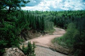 Photo by E. Judziewicz
Situated on terraces inside the sharp meanders of the Nemadji River is a forest type unique to the Lake Superior Clay region. The canopy of dominated by black ash with green ash, basswood, yellow birch, red maple, silver maple, balsam poplar, and bur oak. Scattered conifers are also present in the canopy but are most numerous on the steep slopes bordering the river and terraces. Included among these are white spruce, northern white cedar, white pine, and balsam fir. The herb layer is exceptionally rich and comprised of many plants more typical of maple-basswood forests far to the south.
Spring ephemerals and their associates are especially well-represented, including false rue anemone, wild leek, Virginia waterleaf, toothwort, spring beauty, wild ginger, yellow trout lily, Dutchman's breeches, bloodroot, and blue cohosh. The shrub layer is variable in density with elderberry, beaked hazelnut, and red-osier dogwood. Resident birds include veery, mourning warbler, American redstart, red-eyed vireo, great-crested flycatcher, broad-winged hawk, and pileated woodpecker. The steep, fragile clay slopes will benefit from the protections given by Douglas County. Upper Nemadji River Floodplain Forest is owned by Douglas County and was designated a State Natural Area in 2011.
Very few State Natural Areas have public facilities, but nearly all are open for various recreational activities as indicated below. Generally, there are no picnic areas, restrooms, or other developments. Parking lots or designated parking areas are noted on individual SNA pages and maps. If a developed trail is present, it will normally be noted on the SNA map and/or under the Maps tab. A compass and topographic map or a GPS unit are useful tools for exploring larger, isolated SNAs.
The good majority of SNAs are isolated and have few or no facilities. Some SNAs have vehicle access lanes or parking lots, but their accessibility may vary depending on weather conditions. Parking lots and lanes are not plowed during winter. Hiking trails may be nonexistent or consist of undeveloped footpaths. A GPS unit or compass and a detailed topographic map are useful tools for exploring larger SNAs.
Non-DNR lands
Entrance fees: For non-DNR-owned SNAs, we are unaware of any vehicle or admission fees. However, please contact the landowner for more information.
Hunting and trapping
Other activities
Other allowable activities such as - but not limited to camping, geocaching and bicycling are determined by the landowner. Please contact them directly or visit their websites for details.
Location
Douglas County. T47N-R15W, Sections 14-16, 20, 21, 29. 713 acres.
Driving directions
Situated on both sides of the Nemadji River and is best seen by canoe. Access is available from County W and via Douglas County Forest lands.
The DNR's state natural areas program is comprised of lands owned by the state, private conservation organizations, municipalities, other governmental agencies, educational institutions and private individuals. While the majority of SNAs are open to the public, access may vary according to individual ownership policies. Public use restrictions may apply due to public safety, or to protect endangered or threatened species or unique natural features. Lands may be temporarily closed due to specific management activities. Users are encouraged to contact the landowner for more specific details.
The data shown on these maps have been obtained from various sources, and are of varying age, reliability, and resolution. The data may contain errors or omissions and should not be interpreted as a legal representation of legal ownership boundaries.
To create your custom map where you can zoom to a specific location, please use the DNR's mapping application.
Upper Nemadji Floodplain Forest is owned by: Douglas County