Upper Fox Headwaters
No. 265
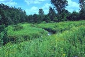
Photo by M. Brust
Upper Fox Headwaters contains three distinct units: Zinke Lake, Upper Chaffee Creek Meadow, and Caves Creek. Zinke Lake is a small hard water spring lake with a tamarack-dominated shore. The water is deep, clear, and cold with limited aquatic vegetation that includes common horsetail, common pondweed, chara, and water milfoil. The spring outlet has a soft sandy bottom and contains white water crowfoot. Other plants include marsh marigold, lousewort, cow parsnip, ironweed, bulbet water hemlock, showy goldenrod, and Missouri goldenrod. The lake's outlet stream is also used by brook trout for spawning.
Upper Chaffee Creek Meadow contains a wetland complex of fen, wet-mesic, and wet prairie with over 100 native plant species present. Running through the site is Chaffee Creek. The creek valley varies between very wet sedge meadow through fen-like areas along the gentle slope north of the creek and grading to the wet-mesic prairie. Grasses include big and little blue-stem, blue-joint grass, and slender wheat grass. Featured forbs are marsh pea, Michigan lily, western sunflower, pale-spike lobelia, Kalm's lobelia, grass-grass-of-Parnassush fern, and swamp lousewort. Caves Creek contains spring seeps and runs, a 2-acre spring pond, a sedge meadow and tamarack swamp, and oak barrens. The spring seeps are floristically rich and are surrounded by a diversity of wetlands. The barrens lie on a south-facing slope and contain a good diversity of prairie species including little blue-stem, June grass, flowering spurge, and bird's-foot violet. Upper Fox Headwaters is owned by the DNR and was designated a State Natural Area in 1998.
Very few State Natural Areas have public facilities, but nearly all are open for a variety of recreational activities as indicated below. Generally, there are no picnic areas, restrooms, or other developments. Parking lots or designated parking areas are noted on individual SNA pages and maps. If a developed trail is present, it will normally be noted on the SNA map and/or under the Maps tab. A compass, topographic map, or GPS unit are useful tools for exploring larger, isolated SNAs.
The good majority of SNAs are isolated and have few or no facilities. Some SNAs have vehicle access lanes or parking lots, but their accessibility may vary depending on weather conditions. Parking lots and lanes are not plowed during winter. Hiking trails may be nonexistent or consist of undeveloped footpaths. A GPS unit or compass and a detailed topographic map are valuable tools for exploring larger SNAs.
Entrance fees: Except for Parfrey's Glen, the Cambrian Outlook in the Dells of the Wisconsin River, SNAs within State Parks and some within State Forests, all other DNR-owned SNAs do not have any admission fees. For more information, see Wis. Admin. Code NR 45 [exit DNR]. For non-DNR-owned SNAs, we are unaware of any vehicle or admission fees. However, please contact the landowner for more information.
Allowable activities: DNR-owned land
The activities listed below are generally allowed on all DNR-owned SNA lands. Exceptions to this list of public uses, such as SNAs closed to hunting, are noted above and posted with signs on the property site.
- Hiking
- Fishing
- Cross country skiing
- Hunting
- Trapping
- Scientific research (permit required [PDF])
- Outdoor education
- Wild edibles (What is this?)
- Pets (Rules)
- Wildlife viewing
Prohibited activities: all SNAs
Although a handful of sites allow activities like primitive camping (e.g. Lower Chippewa River on sand bars) or horseback riding (e.g. S. Kettle Moraine), the activities listed below are generally prohibited on DNR-owned SNAs.
- Camping and campfires
- Collecting of animals (other than legally harvested species), non-edible fungi, rocks, minerals, fossils, archaeological artifacts, soil, downed wood, or any other natural material, alive or dead.
- Collecting for scientific research requires a permit issued by the DNR
- Collecting of plants including seeds, roots or other non-edible parts of herbaceous plants such as wildflowers or grasses
- Drones: Flying-related activities, including the use of drones, hang-gliders and model airplanes, are prohibited. Permission may be issued by the SNA Program for the use of drones for educational or research purposes
- Geocaching
- Horseback riding
- Rock climbing
- Vehicles, including bicycles, ATVs, aircraft, and snowmobiles except on trails and roadways designated for their use.
For rules governing state-owned SNAs and other state lands, please consult Chapter NR 45 Wis. Admin. Code [exit DNR].
Location
Marquette and Waushara County. T17N-R8E, Sections 1, 21, 22. T18N-R8E, Section 36. T18N-R9E, Section 23. 195 acres.
Driving directions
For Chaffee Creek Meadow, from the junction of Highways 21 and 39/51 in Coloma, go south on 51 3.8 miles to rest area 81. Access is available via the Ice Age Trail on the west end of the rest area. Walk northeast into the site. For Caves Creek, from the junction of County Highways A and E in Lawrence, go north on A for 1.7 miles, then continue north on 4th Avenue for 1.7 miles. Park along the road and walk east into the site.
The DNR's state natural areas program is comprised of lands owned by the state, private conservation organizations, municipalities, other governmental agencies, educational institutions and private individuals. While the majority of SNAs are open to the public, access may vary according to individual ownership policies. Public use restrictions may apply due to public safety, or to protect endangered or threatened species or unique natural features. Lands may be temporarily closed due to specific management activities. Users are encouraged to contact the landowner for more specific details.
The data shown on these maps have been obtained from various sources, and are of varying age, reliability, and resolution. The data may contain errors or omissions and should not be interpreted as a legal representation of legal ownership boundaries.
To create your custom map where you can zoom to a specific location, please use the DNR's mapping application.
Upper Fox Headwaters is owned by: Wisconsin DNR