Upper Buckatabon Springs
No. 609
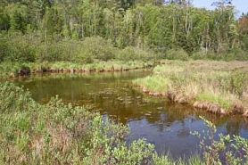
Photo by Randy Hoffman
Upper Buckatabon Springs features a complex of at least five undeveloped soft-water springs and spring ponds that drain into the upper reaches of the Wisconsin River. Collectively, these springs are highly important in maintaining the water quality and quantity of the upper Wisconsin River. Such a concentration of soft-water springs is unusual in this region and within this watershed. Club-spur orchids grow along the spring pond margin while emergent and floating-leaved aquatics are found within the springs. The stream supports an abundance of aquatic macrophyte vegetation that provides significant habitat for aquatic invertebrates and other native wildlife species.
Associated wetlands include shrubby shore fen, alder thicket, northern sedge meadow, and tamarack swamp. The surrounding uplands support good quality stands of mixed red pine and white pine with some mature jack pine present locally. A tiny stand and scattered inclusions of old-growth red pine occur on a narrow ridge and a steep side slope in the northeastern corner of the site. Fire scars are common on many of these larger trees. Along some of the swamp margins are mature second-growth stands of spruce and fir with scattered large remnant white cedars. Mature big-tooth aspen with red oak is present in the northeasternmost forty. Upper Buckatabon Springs is owned by the DNR and the Board of Commissioners of Public Lands. It was designated a State Natural Area in 2010.
Very few State Natural Areas have public facilities, but nearly all are open for a variety of recreational activities as indicated below. Generally, there are no picnic areas, restrooms, or other developments. Parking lots or designated parking areas are noted on individual SNA pages and maps. If a developed trail is present, it will normally be noted on the SNA map and/or under the Maps tab. A compass, topographic map, or GPS unit are useful tools for exploring larger, isolated SNAs.
The good majority of SNAs are isolated and have few or no facilities. Some SNAs have vehicle access lanes or parking lots, but their accessibility may vary depending on weather conditions. Parking lots and lanes are not plowed during winter. Hiking trails may be nonexistent or consist of undeveloped footpaths. A GPS unit or compass and a detailed topographic map are valuable tools for exploring larger SNAs.
Entrance fees: Except for Parfrey's Glen, the Cambrian Outlook in the Dells of the Wisconsin River, SNAs within State Parks and some within State Forests, all other DNR-owned SNAs do not have any admission fees. For more information, see Wis. Admin. Code NR 45 [exit DNR]. For non-DNR-owned SNAs, we are unaware of any vehicle or admission fees. However, please contact the landowner for more information.
Allowable activities: DNR-owned land
The activities listed below are generally allowed on all DNR-owned SNA lands. Exceptions to this list of public uses, such as SNAs closed to hunting, are noted above and posted with signs on the property site.
- Hiking
- Fishing
- Cross country skiing
- Hunting
- Trapping
- Scientific research (permit required [PDF])
- Outdoor education
- Wild edibles (What is this?)
- Pets (Rules)
- Wildlife viewing
Prohibited activities: all SNAs
Although a handful of sites allow activities like primitive camping (e.g. Lower Chippewa River on sand bars) or horseback riding (e.g. S. Kettle Moraine), the activities listed below are generally prohibited on DNR-owned SNAs.
- Camping and campfires
- Collecting of animals (other than legally harvested species), non-edible fungi, rocks, minerals, fossils, archaeological artifacts, soil, downed wood, or any other natural material, alive or dead.
- Collecting for scientific research requires a permit issued by the DNR
- Collecting of plants including seeds, roots or other non-edible parts of herbaceous plants such as wildflowers or grasses
- Drones: Flying-related activities, including the use of drones, hang-gliders and model airplanes, are prohibited. Permission may be issued by the SNA Program for the use of drones for educational or research purposes
- Geocaching
- Horseback riding
- Rock climbing
- Vehicles, including bicycles, ATVs, aircraft, and snowmobiles except on trails and roadways designated for their use.
For rules governing state-owned SNAs and other state lands, please consult Chapter NR 45 Wis. Admin. Code [exit DNR].
Location
Vilas County. T41N-R9E, Sections 10, 11. 279 acres.
Driving directions
From the intersection of US Highway 45 and the Michigan border, go south on 45 for 8.5 miles, then west on County K for 4.7 miles to Buckatabon Creek. The site lies north of the road.
The DNR's state natural areas program is comprised of lands owned by the state, private conservation organizations, municipalities, other governmental agencies, educational institutions and private individuals. While the majority of SNAs are open to the public, access may vary according to individual ownership policies. Public use restrictions may apply due to public safety, or to protect endangered or threatened species or unique natural features. Lands may be temporarily closed due to specific management activities. Users are encouraged to contact the landowner for more specific details.
The data shown on these maps have been obtained from various sources, and are of varying age, reliability, and resolution. The data may contain errors or omissions and should not be interpreted as a legal representation of legal ownership boundaries.
To create your custom map where you can zoom to a specific location, please use the DNR's mapping application.
Upper Buckatabon Springs is owned by: Wisconsin DNR