Upper Brunet River
No. 429
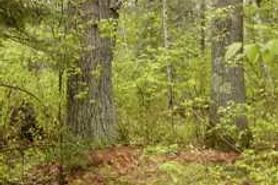 Photo by Linda Parker
Upper Brunet River features a diversity of upland and lowland plant communities. On sandy loam soils are 80-90 years old, fire-origin white pine and red pine growing on the surrounding uplands. Understory associates include blueberry, beaked hazelnut, gaywings, big-leaved aster, and poverty oats. Typical on the lower and mid-slope areas of this land type are northern wet-mesic and dry-mesic hemlock forests. Dominants include hemlock, white cedar, and yellow birch with super-canopy white pine. Understory associates include three-leaved goldthread, mountain wood sorrel, American starflower, bunchberry, and ferns. The wet-mesic phase of this plant community has a strong moss component and is found on lower slopes forming the transition between upland and wetland. Northern mesic forest community types dominate the uplands. Of primary importance is an area of mesic white pine co-dominant with sugar maple.
This is a seral stage (mid-successional) forest that will eventually succeed in sugar maple-hemlock with a white pine super-canopy. Also present is a boreal-like forest dominated by upland tamarack with black spruce, balsam fir, and white pine. The characteristic ground flora includes thimbleberry, bracken fern, big-leaved aster, and wild sarsaparilla. This community is probably of fire origin, serial in nature, and uncommon. Aquatic features include a portion of the Brunet River, which drains over 1/10th of the area of Sawyer County and its headwaters are just east of the SNA. The portion running through and adjacent to the site is classified as Class IA brook trout water. Breeding birds include yellow-rumped, black-throated green, blackburnian, magnolia, black-and-white warblers, ovenbird, and golden-winged warbler. Upper Brunet River is owned by the US Forest Service and was designated a State Natural Area in 2007.
Very few State Natural Areas have public facilities, but nearly all are open for a variety of recreational activities as indicated below. Generally, there are no picnic areas, restrooms, or other developments. Parking lots or designated parking areas are noted on individual SNA pages and maps. If a developed trail is present, it will normally be noted on the SNA map and/or under the Maps tab. A compass and topographic map or a GPS unit are useful tools for exploring larger, isolated SNAs.
The good majority of SNAs are isolated and have few or no facilities. Some SNAs have vehicle access lanes or parking lots, but their accessibility may vary depending on weather conditions. Parking lots and lanes are not plowed during winter. Hiking trails may be nonexistent or consist of undeveloped footpaths. A GPS unit or compass and a detailed topographic map are useful tools for exploring larger SNAs.
Non-DNR lands
Entrance fees: For non-DNR-owned SNAs, we are unaware of any vehicle or admission fees. However, please contact the landowner for more information.
Hunting and trapping
Other activities
Other allowable activities such as - but not limited to camping, geocaching and bicycling are determined by the landowner. Please contact them directly or visit their websites for details.
Location
Within the Chequamegon-Nicolet National Forest, Sawyer County. T40N-R4W, Sections 1, 2, 3, 10-15, 23, 24. 2,547 acres.
Driving directions
From State Highway 70 and County Highway GG in Loretta, go north on GG for about 4 miles, then walk northeast on a snowmobile trail (214) for about 1.3 miles, then walk southeast for 0.4 miles into the site.
The DNR's state natural areas program is comprised of lands owned by the state, private conservation organizations, municipalities, other governmental agencies, educational institutions and private individuals. While the majority of SNAs are open to the public, access may vary according to individual ownership policies. Public use restrictions may apply due to public safety, or to protect endangered or threatened species or unique natural features. Lands may be temporarily closed due to specific management activities. Users are encouraged to contact the landowner for more specific details.
The data shown on these maps have been obtained from various sources, and are of varying age, reliability, and resolution. The data may contain errors or omissions and should not be interpreted as a legal representation of legal ownership boundaries.
To create your custom map where you can zoom to a specific location, please use the DNR's mapping application.
Upper Brunet River is owned by: U.S. Forest Service