Upper Black River
No. 614
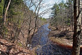 Photo by Aaron Carlson
Upper Black River is a highly complex system of both aquatic and terrestrial communities and diverse in terms of hydrology, topography, soils, animal life, and vegetation. The site protects the stretch of the Black River that runs from the Hatfield Dam at Lake Arbutus south to the city of Black River Falls. Also included are narrow corridors along Morrison Creek, Valentine Creek, and Dickey Creek. Major streamside features include low terraces vegetated with floodplain forest or black ash swamp, slightly higher terraces supporting rich mesic hardwood forest, steep bluffs clad in a dry-mesic forest of pine and oak, and numerous smaller sites containing sandstone cliffs, coves, spring seeps and spring runs. This extensive and diverse site is home to many rare species, some of which are area-sensitive while others are restricted to "southern" habitats such as rich maple-basswood forests. Others are habitat specialists found primarily on cliffs, in seepages, or in association with high-gradient streams.
Protected within this site is Morrison Creek and its associated cliffs and forests. The creek itself is a fast, soft, warm second-order stream that flows through a 2-3 mile long, steep-walled gorge of Cambrian sandstone. The stream gradient is steep, and the bottom has cobbles, boulders, gravel, and sand. Seepages occur along the cliffs flanking the creek. The steep slopes of the narrow Valentine Creek gorge feature a mature dry-mesic forest composed of large white pine and red maple. Other characteristic species are red oak, paper birch, bracken fern, Canada mayflower, wintergreen, and early low-blueberry. The upper slopes contain a dense layer of shrubs and saplings. Small, nearly level terraces occur on the inside bends of meanders and oxbows. The gorge itself opens to the floodplain of the Black River.
Resident birdlife includes species more commonly found in the northern forests such as pine warbler, black-throated green warbler, red-breasted nuthatch, and hermit thrush. The uncommon Louisiana waterthrush, a bird that nests along high-gradient streams flanked by forest has been found along Valentine Creek in the past. The steep sandy slopes along the Dickey Creek corridor support a mature second-growth northern dry-mesic forest. White pine is dominant with some large individuals exceeding 20 inches in diameter. Slopes above the creek vary from nearly vertical, with slumping sandy or clay-shale slopes, to almost level terraces. The ground layer is dominated by Penn sedge, bracken fern, and Canada mayflower with northern species including clubmoss, Canada honeysuckle, three-leaved goldthread, and pink lady's-slipper. Upper Black River is owned by the DNR and was designated a State Natural Area in 2010.
Very few State Natural Areas have public facilities, but nearly all are open for a variety of recreational activities as indicated below. Generally, there are no picnic areas, restrooms, or other developments. Parking lots or designated parking areas are noted on individual SNA pages and maps. If a developed trail is present, it will normally be noted on the SNA map and/or under the Maps tab. A compass and topographic map or a GPS unit are useful tools for exploring larger, isolated SNAs.
The good majority of SNAs are isolated and have few or no facilities. Some SNAs have vehicle access lanes or parking lots, but their accessibility may vary depending on weather conditions. Parking lots and lanes are not plowed during winter. Hiking trails may be nonexistent or consist of undeveloped footpaths. A GPS unit or compass and a detailed topographic map are useful tools for exploring larger SNAs.
Entrance fees: Except for Parfrey's Glen, the Cambrian Outlook in the Dells of the Wisconsin River, SNAs within State Parks and some within State Forests, all other DNR-owned SNAs do not have any admission fees. For more information, see Wis. Admin. Code NR 45 [exit DNR]. For non-DNR-owned SNAs, we are unaware of any vehicle or admission fees. However, please contact the landowner for more information.
Allowable activities: DNR-owned land
The activities listed below are generally allowed on all DNR-owned SNA lands. Exceptions to this list of public uses, such as SNAs closed to hunting, are noted above and posted with signs on the property site.
- Hiking
- Fishing
- Cross country skiing
- Hunting
- Trapping
- Scientific research (permit required [PDF])
- Outdoor education
- Wild edibles (What is this?)
- Pets (Rules)
- Wildlife viewing
Prohibited activities: all SNAs
Although a handful of sites allow activities like primitive camping (e.g. Lower Chippewa River on sand bars) or horseback riding (e.g. S. Kettle Moraine), the activities listed below are generally prohibited on DNR-owned SNAs.
- Camping and campfires
- Collecting of animals (other than legally harvested species), non-edible fungi, rocks, minerals, fossils, archaeological artifacts, soil, downed wood, or any other natural material, alive or dead.
- Collecting for scientific research requires a permit issued by the DNR
- Collecting of plants including seeds, roots or other non-edible parts of herbaceous plants such as wildflowers or grasses
- Drones: Flying-related activities, including the use of drones, hang-gliders and model airplanes, are prohibited. Permission may be issued by the SNA Program for the use of drones for educational or research purposes
- Geocaching
- Horseback riding
- Rock climbing
- Vehicles, including bicycles, ATVs, aircraft, and snowmobiles except on trails and roadways designated for their use.
For rules governing state-owned SNAs and other state lands, please consult Chapter NR 45 Wis. Admin. Code [exit DNR].
Location
Within the Black River State Forest, Jackson County. T22N-R3W, Sections 9, 15, 16, 17, 19, 21, 22, 28-31. T22N-R4W, Section 36. 1,562 acres.
Driving directions
From the intersection of I-94 and Highway 12 in Black River Falls, go west on Highway 12 for 2.1 miles, then north on County E for 2.5 miles, then east 0.4 miles on an access road to carry-in boat access.
The DNR's state natural areas program is comprised of lands owned by the state, private conservation organizations, municipalities, other governmental agencies, educational institutions and private individuals. While the majority of SNAs are open to the public, access may vary according to individual ownership policies. Public use restrictions may apply due to public safety, or to protect endangered or threatened species or unique natural features. Lands may be temporarily closed due to specific management activities. Users are encouraged to contact the landowner for more specific details.
The data shown on these maps have been obtained from various sources, and are of varying age, reliability, and resolution. The data may contain errors or omissions and should not be interpreted as a legal representation of legal ownership boundaries.
To create your custom map where you can zoom to a specific location, please use the DNR's mapping application.
Upper Black River is owned by: Wisconsin DNR