Tucker Lake Hemlocks
No. 296
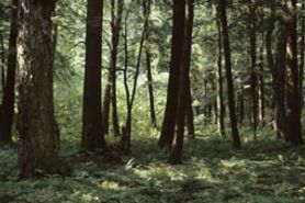 Photo by E. Epstein
Tucker Lake Hemlocks contains an old-growth hemlock and yellow birch forest located on Tucker Lake, a large, undeveloped soft-water drainage lake. The forest shows some evidence of past selective harvest but is essentially unmanipulated. Canopy dominants are hemlock and yellow birch with basswood, red maple, white ash, balsam fir, and white pine. The shrub layer is generally sparse except where canopy gaps allow sunlight to penetrate the forest floor. Shrubs include mountain maple, beaked hazelnut, fly honeysuckle, and red elder. Herbs include shrub moss, wood sorrel, small enchanter's nightshade, American starflower, Canada mayflower, rosy twisted-stalk, spotted coralroot, and intermediate wood fern. Numerous birds inhabit the area including the bald eagle and osprey. Other breeding birds are blackburnian, northern parula, and black-throated green warblers, red-eyed vireo, ovenbird, least flycatcher, and brown creeper. Tucker Lake Hemlocks is owned by the U.S. Forest Service and was designated a State Natural Area in 1996. This site is also recognized by the Forest Service as an established Research Natural Area.
Very few State Natural Areas have public facilities, but nearly all are open for a variety of recreational activities as indicated below. Generally, there are no picnic areas, restrooms, or other developments. Parking lots or designated parking areas are noted on individual SNA pages and maps. If a developed trail is present, it will normally be noted on the SNA map and/or under the Maps tab. A compass and topographic map or a GPS unit are useful tools for exploring larger, isolated SNAs.
The good majority of SNAs are isolated and have few or no facilities. Some SNAs have vehicle access lanes or parking lots, but their accessibility may vary depending on weather conditions. Parking lots and lanes are not plowed during winter. Hiking trails may be nonexistent or consist of undeveloped footpaths. A GPS unit or compass and a detailed topographic map are useful tools for exploring larger SNAs.
Non-DNR lands
Entrance fees: For non-DNR-owned SNAs, we are unaware of any vehicle or admission fees. However, please contact the landowner for more information.
Hunting and trapping
Other activities
Other allowable activities such as - but not limited to camping, geocaching and bicycling are determined by the landowner. Please contact them directly or visit their websites for details.
Location
Within the Chequamegon-Nicolet National Forest, Price County. T40N-R3E, Sections 13, 24. T40N-4E, Sections 18, 19. 674 acres.
Driving directions
From Fifield, go east on State Highway 70 for 17 miles, then north on FR 144 for 2.2 miles, then east on FR 535 for 0.5 miles to the Round Lake Ski Trail. Follow the trail north 1.5 miles to the site. Or from 70, go north and west on FR 144 for 5 miles, then north and east on FR 142 for 2.6 miles to a marked hiking trail. Walk south 1 mile to the north shore of Round Lake, then follow the trail east 0.25 miles to the old-growth hemlock stand. A map and compass are recommended.
The DNR's state natural areas program is comprised of lands owned by the state, private conservation organizations, municipalities, other governmental agencies, educational institutions and private individuals. While the majority of SNAs are open to the public, access may vary according to individual ownership policies. Public use restrictions may apply due to public safety, or to protect endangered or threatened species or unique natural features. Lands may be temporarily closed due to specific management activities. Users are encouraged to contact the landowner for more specific details.
The data shown on these maps have been obtained from various sources, and are of varying age, reliability, and resolution. The data may contain errors or omissions and should not be interpreted as a legal representation of legal ownership boundaries.
To create your custom map where you can zoom to a specific location, please use the DNR's mapping application.
Tucker Lake Hemlocks is owned by: U.S. Forest Service