Trenton Bluff Prairie
No. 136
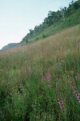 Photo by Thomas A. Meyer/DNR
Trenton Bluff Prairie consists of two separate dry prairies situated on steep Mississippi River sandstone bluffs capped by massive limestone cliffs. They are some of the best prairie remaining in the region. The western unit has two prairie openings separated by a wooded draw while the eastern portion is much steeper and contains an open cliff grading quickly into shrubby oak woods. The bluff summit rises some 300 feet above the flat, sandy river terrace below with vertical cliffs exposing the bedrock layers showing dolomite limestone atop the basal sandstone.
Dominant grasses include Indian grass, little blue-stem, big blue-stem, side-oats grama, and needle grass. Located near the far western edge of the state, the prairie contains several Great Plains species at their eastern range limit here including plains muhly (Muhlenbergia cuspidata), and prairie larkspur (Delphinium carolinianum). The upper cliff area has numerous outcrop crevices that harbor several interesting fern species including slender lip fern and smooth cliff brake. Trenton Bluff Prairie is owned by the DNR and was designated a State Natural Area in 1977.
Very few State Natural Areas have public facilities, but nearly all are open for a variety of recreational activities as indicated below. Generally, there are no picnic areas, restrooms, or other developments. Parking lots or designated parking areas are noted on individual SNA pages and maps. If a developed trail is present, it will normally be noted on the SNA map and/or under the Maps tab. A compass and topographic map or a GPS unit are useful tools for exploring larger, isolated SNAs.
The good majority of SNAs are isolated and have few or no facilities. Some SNAs have vehicle access lanes or parking lots, but their accessibility may vary depending on weather conditions. Parking lots and lanes are not plowed during winter. Hiking trails may be nonexistent or consist of undeveloped footpaths. A GPS unit or compass and a detailed topographic map are useful tools for exploring larger SNAs.
Hunting and trapping
Allowable activities: DNR-owned land
The activities listed below are generally allowed on all DNR-owned SNA lands. Exceptions to this list of public uses, such as SNAs closed to hunting, are noted above and posted with signs on the property site.
- Hiking
- Fishing
- Cross country skiing
- Hunting
- Trapping
- Scientific research (permit required [PDF])
- Outdoor education
- Wild edibles (What is this?)
- Pets (Rules)
- Wildlife viewing
Prohibited activities: all SNAs
- Camping and campfires
- Collecting of animals (other than legally harvested species), non-edible fungi, rocks, minerals, fossils, archaeological artifacts, soil, downed wood, or any other natural material, alive or dead.
- Collecting for scientific research requires a permit issued by the DNR
- Collecting of plants including seeds, roots or other non-edible parts of herbaceous plants such as wildflowers or grasses
- Geocaching
- Horseback riding
- Rock climbing
- Vehicles, including bicycles, ATVs, aircraft, and snowmobiles except on trails and roadways designated for their use.
For rules governing state-owned SNAs and other state lands, please consult Chapter NR 45 Wis. Admin. Code [exit DNR].
Location
Pierce County. T25N-R18W, Sections 28, 34, 35. 130 acres.
Driving directions
From the intersection of Highways 35 and VV north of Hager City, go west on 35 1.5 miles to a small pull-off in a wooded draw north of the road. For the eastern unit, go north on VV 0.4 mile and park along the road. Walk due west through the woods and upslope to the prairie.
The DNR's state natural areas program is comprised of lands owned by the state, private conservation organizations, municipalities, other governmental agencies, educational institutions and private individuals. While the majority of SNAs are open to the public, access may vary according to individual ownership policies. Public use restrictions may apply due to public safety, or to protect endangered or threatened species or unique natural features. Lands may be temporarily closed due to specific management activities. Users are encouraged to contact the landowner for more specific details.
The data shown on these maps have been obtained from various sources, and are of varying age, reliability, and resolution. The data may contain errors or omissions and should not be interpreted as a legal representation of legal ownership boundaries.
To create your custom map where you can zoom to a specific location, please use the DNR's mapping application.
Trenton Bluff Prairie is owned by: Private and the Wisconsin DNR
Management objectives and prescriptions
Read the Trenton Bluff Prairie management plan [PDF] for details.