Tranus Lake
No. 277
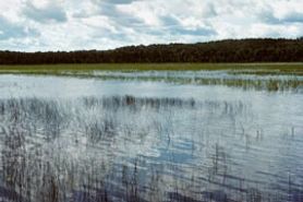 Photo by E. Epstein
Tranus Lake is a 175- acre soft water drainage lake near the headwaters of Tranus Creek, which drains into the Namekagon River. The lake has retained its wilderness aspect, which is unique for a lake of this size. The shallow lake basin (12-foot maximum) supports extensive beds of wild rice and numerous other species of aquatic plants soft-stem bulrush and arrowhead. On the west shore of the lake are large areas of hard-stem bulrush and a floating mat of sphagnum moss and sedges.
Adjoining the wetland is a conifer swamp of black spruce and tamarack with a dense understory of leather leaf. A northern sedge meadow with tamarack and alder dominates the north end of the lake. The surrounding uplands are forested with second-growth stands of sugar maple, paper birch, and aspen. Osprey has nested here and large numbers of diving ducks and coots use the lake during spring and fall migration. Tranus Lake is owned by Washburn County and was designated a State Natural Area in 1993.
Very few State Natural Areas have public facilities, but nearly all are open for a variety of recreational activities as indicated below. Generally, there are no picnic areas, restrooms, or other developments. Parking lots or designated parking areas are noted on individual SNA pages and maps. If a developed trail is present, it will normally be noted on the SNA map and/or under the Maps tab. A compass and topographic map or a GPS unit are useful tools for exploring larger, isolated SNAs.
The good majority of SNAs are isolated and have few or no facilities. Some SNAs have vehicle access lanes or parking lots, but their accessibility may vary depending on weather conditions. Parking lots and lanes are not plowed during winter. Hiking trails may be nonexistent or consist of undeveloped footpaths. A GPS unit or compass and a detailed topographic map are useful tools for exploring larger SNAs.
Non-DNR lands
Entrance fees: For non-DNR-owned SNAs, we are unaware of any vehicle or admission fees. However, please contact the landowner for more information.
Hunting and trapping
Other activities
Other allowable activities such as - but not limited to camping, geocaching and bicycling are determined by the landowner. Please contact them directly or visit their websites for details.
Location
Within Washburn County Forest, Washburn County. T41N-R10W, Sections 19, 30. 214 acres.
Driving directions
From the intersection of Highways 63 and M in Springbrook, go east on 63 for about 3.2 miles, then north on Tranus Lake Road for 2.2 miles, then west on Tranus Lake Landing Road for 0.2 miles to a boat landing and parking area. The lake is best explored by canoe.
The DNR's state natural areas program is comprised of lands owned by the state, private conservation organizations, municipalities, other governmental agencies, educational institutions and private individuals. While the majority of SNAs are open to the public, access may vary according to individual ownership policies. Public use restrictions may apply due to public safety, or to protect endangered or threatened species or unique natural features. Lands may be temporarily closed due to specific management activities. Users are encouraged to contact the landowner for more specific details.
The data shown on these maps have been obtained from various sources, and are of varying age, reliability, and resolution. The data may contain errors or omissions and should not be interpreted as a legal representation of legal ownership boundaries.
To create your custom map where you can zoom to a specific location, please use the DNR's mapping application.
Tranus Lake is owned by: Washburn County