Tiffany Bottoms
No. 30
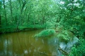 Photo by Thomas A. Meyer/DNR
Tiffany Bottoms State Natural Area is a small portion of the most extensive river delta in the Midwest and contains a representative portion of the larger Tiffany Bottoms floodplain forest. The site captures the transition between the typical floodplain forest of silver maple, river birch, ashes, and basswood in the southern portion and the more oak-dominated forest in the northern part (swamp white, bur, and black). Soil types also change, from sandy outwash in the north to sand with accumulations of silty alluvium in the south. The bottoms abound in wildlife.
Besides the typical game species, the area contains rare and uncommon raptors, warblers as well as great-blue herons, pileated woodpeckers, and blue-gray gnatcatcher. The State Natural Area is part of an extensive 8,000-acre beaver/otter closed area, which has been maintained in the Tiffany Wildlife Area since 1956. The closed area was established in recognition of the fact that beavers are a very important habitat-altering species that can have very positive impacts on other wetland-dependent plants and animals. Maintaining this closed area is an important tool for maintaining this diverse wetland complex. Tiffany Bottoms is owned by the DNR and was designated a State Natural Area in 1958.
Very few State Natural Areas have public facilities, but nearly all are open for a variety of recreational activities as indicated below. Generally, there are no picnic areas, restrooms, or other developments. Parking lots or designated parking areas are noted on individual SNA pages and maps. If a developed trail is present, it will normally be noted on the SNA map and/or under the Maps tab. A compass and topographic map or a GPS unit are useful tools for exploring larger, isolated SNAs.
The good majority of SNAs are isolated and have few or no facilities. Some SNAs have vehicle access lanes or parking lots, but their accessibility may vary depending on weather conditions. Parking lots and lanes are not plowed during winter. Hiking trails may be nonexistent or consist of undeveloped footpaths. A GPS unit or compass and a detailed topographic map are useful tools for exploring larger SNAs.
Entrance fees: Except for Parfrey's Glen, the Cambrian Outlook in the Dells of the Wisconsin River, SNAs within State Parks and some within State Forests, all other DNR-owned SNAs do not have any admission fees. For more information, see Wis. Admin. Code NR 45 [exit DNR]. For non-DNR-owned SNAs, we are unaware of any vehicle or admission fees. However, please contact the landowner for more information.
Allowable activities: DNR-owned land
The activities listed below are generally allowed on all DNR-owned SNA lands. Exceptions to this list of public uses, such as SNAs closed to hunting, are noted above and posted with signs on the property site.
- Hiking
- Fishing
- Cross country skiing
- Hunting
- Trapping
- Scientific research (permit required [PDF])
- Outdoor education
- Wild edibles (What is this?)
- Pets (Rules)
- Wildlife viewing
Prohibited activities: all SNAs
Although a handful of sites allow activities like primitive camping (e.g. Lower Chippewa River on sand bars) or horseback riding (e.g. S. Kettle Moraine), the activities listed below are generally prohibited on DNR-owned SNAs.
- Camping and campfires
- Collecting of animals (other than legally harvested species), non-edible fungi, rocks, minerals, fossils, archaeological artifacts, soil, downed wood, or any other natural material, alive or dead.
- Collecting for scientific research requires a permit issued by the DNR
- Collecting of plants including seeds, roots or other non-edible parts of herbaceous plants such as wildflowers or grasses
- Drones: Flying-related activities, including the use of drones, hang-gliders and model airplanes, are prohibited. Permission may be issued by the SNA Program for the use of drones for educational or research purposes
- Geocaching
- Horseback riding
- Rock climbing
- Vehicles, including bicycles, ATVs, aircraft, and snowmobiles except on trails and roadways designated for their use.
For rules governing state-owned SNAs and other state lands, please consult Chapter NR 45 Wis. Admin. Code [exit DNR].
Location
Within Tiffany Wildlife Area, Buffalo County. T23N-R14W, Section 1. T24N-R14W, Sections 25, 26, 35, 36. 718 acres.
Driving directions
From Nelson go north on Highway 25 seven miles to a parking area, then overland and across Buffalo Slough to the site. Or from Ella by boat, directly across the Chippewa River to the north boundary. This area is closed to beaver and otter trapping.
Primitive camping is allowed by permit only. Upon completion of the camping permit [PDF], retain the original with you at your campsite, post a copy on the dash of each vehicle in your party and send a copy to the DNR Alma office.
The DNR's state natural areas program comprises lands owned by the state, private conservation organizations, municipalities, other governmental agencies, educational institutions and private individuals. While the majority of SNAs are open to the public, access may vary according to individual ownership policies. Public use restrictions may apply due to public safety, or to protect endangered or threatened species or unique natural features. Lands may be temporarily closed due to specific management activities. Users are encouraged to contact the landowner for more specific details.
The data shown on these maps have been obtained from various sources, and are of varying age, reliability, and resolution. The data may contain errors or omissions and should not be interpreted as a legal representation of legal ownership boundaries.
To create your custom map where you can zoom to a specific location, please use the DNR's mapping application.
Tiffany Bottoms is owned by: Wisconsin DNR