Thunder River Swamp
No. 488
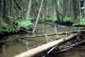 Photo by U.S. Forest Service
The Thunder River Swamp complex contains both upland and lowland areas of exceptional quality. Three habitat types (PMV, ATM, and AQVib) are found within 260 acres of upland forest. One of the included stands contains minimally disturbed old-growth white pine and is a known nesting site for red-shouldered hawks and great blue herons. The high-quality lowland swamps found here are mostly white cedar with smaller areas of mixed conifer swamp and alder thickets and support numerous rare plant species. The best quality cedar swamp is located at the south end of the complex, along the Thunder River. The canopy here is white cedar, with less understory balsam fir and black spruce than in other areas. The ground layer is especially diverse.
The Thunder River and three unnamed creeks, with associated narrow riparian communities, occur along or within the swamps of the complex. One small stream begins with a large spring pond headwater and continues for a mile and a half, connecting with the North Fork of the Thunder River. Another connects with Caldron Falls Reservoir. Upland areas include both northern dry-mesic and northern mesic forests. The northern dry-mesic forest is dominated by white pine, sugar maple, and paper birch with red maple, and aspen. Also present is a northern mesic forest of paper birch, red oak, and sugar maple. Several large stands within this forest, typed as "cedar-aspen-paper birch", are a matrix of small conifer swamps and mixed upland hardwood areas. Thunder River Swamp is owned by the US Forest Service and was designated a State Natural Area in 2007.
Very few State Natural Areas have public facilities, but nearly all are open for a variety of recreational activities as indicated below. Generally, there are no picnic areas, restrooms, or other developments. Parking lots or designated parking areas are noted on individual SNA pages and maps. If a developed trail is present, it will normally be noted on the SNA map and/or under the Maps tab. A compass and topographic map or a GPS unit are useful tools for exploring larger, isolated SNAs.
The good majority of SNAs are isolated and have few or no facilities. Some SNAs have vehicle access lanes or parking lots, but their accessibility may vary depending on weather conditions. Parking lots and lanes are not plowed during winter. Hiking trails may be nonexistent or consist of undeveloped footpaths. A GPS unit or compass and a detailed topographic map are useful tools for exploring larger SNAs.
Non-DNR lands
Entrance fees: For non-DNR-owned SNAs, we are unaware of any vehicle or admission fees. However, please contact the landowner for more information.
Hunting and trapping
Other activities
Other allowable activities such as - but not limited to camping, geocaching and bicycling are determined by the landowner. Please contact them directly or visit their websites for details.
Location
Within the Chequamegon-Nicolet National Forest. Oconto County. T33N-R17E Sections 2, 10, 11, 14, 15. 638 acres.
Driving directions
The site occupies 9 square miles in the northeast corner of Oconto County, approximately 4 miles north and 8 miles east of Lakewood, Wisconsin. From Highway 32 and County F in Lakewood, go east and north on County F for 3.1 miles, then east on Smyth Road for 4 miles, then north on Holt Ranch Road for 0.7 miles, then east on Bucks Ranch Road for 1 mile, then north on N. Fork Road 2.1 miles. Walk east into the site.
The DNR's state natural areas program comprises lands owned by the state, private conservation organizations, municipalities, other governmental agencies, educational institutions and private individuals. While the majority of SNAs are open to the public, access may vary according to individual ownership policies. Public use restrictions may apply due to public safety, or to protect endangered or threatened species or unique natural features. Lands may be temporarily closed due to specific management activities. Users are encouraged to contact the landowner for more specific details.
The data shown on these maps have been obtained from various sources, and are of varying age, reliability, and resolution. The data may contain errors or omissions and should not be interpreted as a legal representation of legal ownership boundaries.
To create your custom map where you can zoom to a specific location, please use the DNR's mapping application.
Thunder River Swamp is owned by: U.S. Forest Service