Thunder Mountain
No. 491
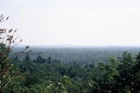 Photo by U.S. Forest Service
Thunder Mountain is a quartzite monadnock that rises 360 feet above the wetlands at its base and affords picturesque views of the surrounding Forest. It is one of the largest of several promontories in the southern portion of the Nicolet National Forest that are not drumlins, but are bedrock outcrops, predating the Pleistocene, actually of the Precambrian era, dating to the early and middle Proterozoic division. It has exposed bedrock on the southern flank, and these support a rare plant.
Two other rare plants are also found on the mountain. Several spring seeps are on the mountainside. The forest on the slopes is more southern in its biota than normally found on the Nicolet. It is classed as a southern dry-mesic forest, dominated by regenerating red oak and white oak, especially on the south-facing slopes. The lowlands at the base contain white cedar and black ash swamps, a river corridor, and a small silver maple floodplain forest. Other notable species include the parasitic plant American cancer root and the turkey vulture. Thunder Mountain is owned by the US Forest Service and was designated a State Natural Area in 2007.
Very few State Natural Areas have public facilities, but nearly all are open for a variety of recreational activities as indicated below. Generally, there are no picnic areas, restrooms, or other developments. Parking lots or designated parking areas are noted on individual SNA pages and maps. If a developed trail is present, it will normally be noted on the SNA map and/or under the Maps tab. A compass and topographic map or a GPS unit are useful tools for exploring larger, isolated SNAs.
The good majority of SNAs are isolated and have few or no facilities. Some SNAs have vehicle access lanes or parking lots, but their accessibility may vary depending on weather conditions. Parking lots and lanes are not plowed during winter. Hiking trails may be nonexistent or consist of undeveloped footpaths. A GPS unit or compass and a detailed topographic map are useful tools for exploring larger SNAs.
Non-DNR lands
Entrance fees: For non-DNR-owned SNAs, we are unaware of any vehicle or admission fees. However, please contact the landowner for more information.
Hunting and trapping
Other activities
Other allowable activities such as - but not limited to camping, geocaching and bicycling are determined by the landowner. Please contact them directly or visit their websites for details.
Location
Within the Chequamegon-Nicolet National Forest. Oconto County. T33N-R17E, Sections 25, 36. 75 acres.
Driving directions
From the intersection of State Highway 32 and County Highway W in Mountain, go east on County W for 8.5 miles, then north on FR 2101 (La Fave Road) for 4.6 miles. Walk east and north on a trail 0.8 miles, then head due east 0.2 miles into the site.
The DNR's state natural areas program comprises lands owned by the state, private conservation organizations, municipalities, other governmental agencies, educational institutions and private individuals. While the majority of SNAs are open to the public, access may vary according to individual ownership policies. Public use restrictions may apply due to public safety, or to protect endangered or threatened species or unique natural features. Lands may be temporarily closed due to specific management activities. Users are encouraged to contact the landowner for more specific details.
The data shown on these maps have been obtained from various sources, and are of varying age, reliability, and resolution. The data may contain errors or omissions and should not be interpreted as a legal representation of legal ownership boundaries.
To create your custom map where you can zoom to a specific location, please use the DNR's mapping application.
Thunder Mountain is owned by: U.S. Forest Service