Thorp Pond
No. 403
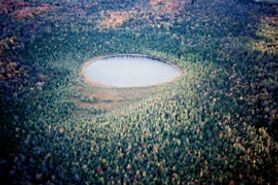 Photo by E. Epstein
Thorp Pond contains a mosaic of wetland communities including boreal rich fen, northern wet-mesic forest and hardwood swamp. The 6.4-acre seepage pond is a hard-water bog lake ringed by tall shrubs, coarse sedges, and cedar saplings. Surrounding the small pond is the boreal-rich fen - an open wetland that features an exceptionally diverse plant community with numerous fen species. In some areas, tussocks of sedges and bulrush are separated by muck pockets vegetated with beaked bladderwort and white beak-rush along with sundews.
Elsewhere, characteristic fen species are present including grass-of-Parnassus, bog buckbean, lake sedge, and northern bog goldenrod. An extensive, mature forest dominated by white cedar, tamarack, black spruce, and black ash borders the fen. All but tamarack are reproducing successfully. Other trees include white spruce, balsam fir, yellow birch, and red maple. Shrubs include alder-leaf buckthorn, red-osier dogwood, and creeping snowberry. The herbaceous layer contains dwarf red raspberry, naked miterwort, green adder's-mouth, moccasin flower, and numerous sedges.
Green ash and red maple along with black ash dominate the hardwood swamp, a rare community in this ecoregion. Characteristic herbs include marsh fern, cinnamon fern, royal fern, American water-horehound, water parsnip, and hop sedge. To the east, dominance shifts to conifers, with a corresponding change in the ground layer as well. Thorp Pond is owned in part by the DNR and by private individuals (see the map and directions for public access). It was designated a State Natural Area in 2003.
Very few State Natural Areas have public facilities, but nearly all are open for a variety of recreational activities as indicated below. Generally, there are no picnic areas, restrooms, or other developments. Parking lots or designated parking areas are noted on individual SNA pages and maps. If a developed trail is present, it will normally be noted on the SNA map and/or under the Maps tab. A compass and topographic map or a GPS unit are useful tools for exploring larger, isolated SNAs.
The good majority of SNAs are isolated and have few or no facilities. Some SNAs have vehicle access lanes or parking lots, but their accessibility may vary depending on weather conditions. Parking lots and lanes are not plowed during winter. Hiking trails may be nonexistent or consist of undeveloped footpaths. A GPS unit or compass and a detailed topographic map are useful tools for exploring larger SNAs.
Hunting and trapping
Entrance fees: Except for Parfrey's Glen, the Cambrian Outlook in the Dells of the Wisconsin River, SNAs within State Parks and some within State Forests, all other DNR-owned SNAs do not have any admission fees. For more information, see Wis. Admin. Code NR 45 [exit DNR]. For non-DNR-owned SNAs, we are unaware of any vehicle or admission fees. However, please contact the landowner for more information.
Allowable activities: DNR-owned land
The activities listed below are generally allowed on all DNR-owned SNA lands. Exceptions to this list of public uses, such as SNAs closed to hunting, are noted above and posted with signs on the property site.
- Hiking
- Fishing
- Cross country skiing
- Hunting
- Trapping
- Scientific research (permit required [PDF])
- Outdoor education
- Wild edibles (What is this?)
- Pets (Rules)
- Wildlife viewing
Prohibited activities: all SNAs
- Camping and campfires
- Collecting of animals (other than legally harvested species), non-edible fungi, rocks, minerals, fossils, archaeological artifacts, soil, downed wood, or any other natural material, alive or dead.
- Collecting for scientific research requires a permit issued by the DNR
- Collecting of plants including seeds, roots or other non-edible parts of herbaceous plants such as wildflowers or grasses
- Drones: Flying-related activities, including the use of drones, hang-gliders and model airplanes, are prohibited. Permission may be issued by the SNA Program for the use of drones for educational or research purposes
- Geocaching
- Horseback riding
- Rock climbing
- Vehicles, including bicycles, ATVs, aircraft, and snowmobiles except on trails and roadways designated for their use.
For rules governing state-owned SNAs and other state lands, please consult Chapter NR 45 Wis. Admin. Code [exit DNR].
Location
Door County. T30N-R27E, Section 16, 17. 184 acres.
Driving directions
From the junction of County G (Horseshoe Bay Road) and State Highway 42 in Egg Harbor, go north on 42 for 1.75 miles, then east on County EE for 0.8 miles, then north on Quarterline Road for 0.5 miles, then east on Quarterline Road East 0.3 mile to its end. Park and walk southeast into the site. The map delineates land open to the public.
The DNR's state natural areas program comprises lands owned by the state, private conservation organizations, municipalities, other governmental agencies, educational institutions and private individuals. While the majority of SNAs are open to the public, access may vary according to individual ownership policies. Public use restrictions may apply due to public safety, or to protect endangered or threatened species or unique natural features. Lands may be temporarily closed due to specific management activities. Users are encouraged to contact the landowner for more specific details.
The data shown on these maps have been obtained from various sources, and are of varying age, reliability, and resolution. The data may contain errors or omissions and should not be interpreted as a legal representation of legal ownership boundaries.
To create your custom map where you can zoom to a specific location, please use the DNR's mapping application.
Thorp Pond is owned by: Private and Wisconsin DNR
Management objectives and prescriptions
Read the Thorp Pond management plan [PDF] for details.