Thornapple Hemlocks
No. 459
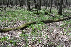 Photo by U.S. Forest Service
Thornapple Hemlocks is a medium-sized complex that contains a good representation of most of the major community types found within this land type (Flambeau Silt-capped Drumlins). Included within the site are good quality examples of the rich, maple-basswood forest, hemlock-hardwood forest, lowland transitional hemlock forest, mixed hardwood swamp forest, and black spruce-tamarack bog. Of the above, the upland hemlock-hardwood forest is most noteworthy in that this forest type was historically the dominant land cover on this land type.
On level, somewhat poorly drained ground moraine is a northern mesic to a wet-mesic forest dominated by 10-12" and 20"+ hemlock with yellow birch, red maple, and super-canopy white pine and white spruce. Northern white cedar is occasionally present in localized areas. Yellow birch saplings on stumps and old tip-ups, and balsam fir and white spruce saplings in canopy gaps are the common understory species. The shrub layer is sparse and poorly developed with a predominantly open understory. Typical ground layer species include Canada mayflower, American starflower, yellow blue-bead lily, three-leaved goldthread, wood ferns, and bunchberry, with sphagnum moss and cinnamon fern in the wettest areas. A narrow intermittent feeder stream of Log Creek drains an adjacent black spruce and tamarack bog as it flows south through the stand. It is closed canopied with a sand and gravel bottom. To the west, conditions become wetter and the community type changes.
Very few State Natural Areas have public facilities, but nearly all are open for a variety of recreational activities as indicated below. Generally, there are no picnic areas, restrooms, or other developments. Parking lots or designated parking areas are noted on individual SNA pages and maps. If a developed trail is present, it will normally be noted on the SNA map and/or under the Maps tab. A compass and topographic map or a GPS unit are useful tools for exploring larger, isolated SNAs.
The good majority of SNAs are isolated and have few or no facilities. Some SNAs have vehicle access lanes or parking lots, but their accessibility may vary depending on weather conditions. Parking lots and lanes are not plowed during winter. Hiking trails may be nonexistent or consist of undeveloped footpaths. A GPS unit or compass and a detailed topographic map are useful tools for exploring larger SNAs.
Non-DNR lands
Entrance fees: For non-DNR-owned SNAs, we are unaware of any vehicle or admission fees. However, please contact the landowner for more information.
Hunting and trapping
Other activities
Other allowable activities such as - but not limited to camping, geocaching and bicycling are determined by the landowner. Please contact them directly or visit their websites for details.
Location
Within the Chequamegon-Nicolet National Forest.Sawyer County. T40N-R3W, 10, 11, 14, 15, 16, 21, 22. 455 acres.
Driving directions
The site can be accessed from Forest Trail 209. From the intersection of Highway 70 and FR 162 just east of Draper, go north on FR 162 for about 5.1 miles, then east on FR 161 for 0.8 miles, then south on Forest Trail 209 to the site.
The DNR's state natural areas program comprises lands owned by the state, private conservation organizations, municipalities, other governmental agencies, educational institutions and private individuals. While the majority of SNAs are open to the public, access may vary according to individual ownership policies. Public use restrictions may apply due to public safety, or to protect endangered or threatened species or unique natural features. Lands may be temporarily closed due to specific management activities. Users are encouraged to contact the landowner for more specific details.
The data shown on these maps have been obtained from various sources, and are of varying age, reliability, and resolution. The data may contain errors or omissions and should not be interpreted as a legal representation of legal ownership boundaries.
To create your custom map where you can zoom to a specific location, please use the DNR's mapping application.
Thornapple Hemlocks is owned by: U.S. Forest Service