Tealey Creek Cedars
No. 632
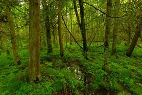 Photo by Josh Mayer
Tealey Creek Cedars occupies a low terrace along the lower end of Tealey Creek, just above its confluence with Mud Creek where it drains off the hilly end moraine and through gently rolling ground moraine. The site supports a high conservation value forest of high-quality white cedar-black ash swamps. White cedar is rare in this part of the state and this swamp represents the largest and best quality example of this community type in the county forest. Many of the cedars are 18 inches in diameter. Balsam fir and red maple are canopy associates. The swamp has a diverse structure including frequent blowdowns, tip-up mounds, fallen trees, snags, and hummock-hollow microtopography. Disturbances appear to be minimal at this site, although water level alteration by a beaver is a concern for the rare plants found here. Tealey Creek Cedars is owned by Chippewa County and was designated a State Natural Area in 2010.
Very few State Natural Areas have public facilities, but nearly all are open for a variety of recreational activities as indicated below. Generally, there are no picnic areas, restrooms, or other developments. Parking lots or designated parking areas are noted on individual SNA pages and maps. If a developed trail is present, it will normally be noted on the SNA map and/or under the Maps tab. A compass and topographic map or a GPS unit are useful tools for exploring larger, isolated SNAs.
The good majority of SNAs are isolated and have few or no facilities. Some SNAs have vehicle access lanes or parking lots, but their accessibility may vary depending on weather conditions. Parking lots and lanes are not plowed during winter. Hiking trails may be nonexistent or consist of undeveloped footpaths. A GPS unit or compass and a detailed topographic map are useful tools for exploring larger SNAs.
Non-DNR lands
Entrance fees: For non-DNR-owned SNAs, we are unaware of any vehicle or admission fees. However, please contact the landowner for more information.
Hunting and trapping
Other activities
Other allowable activities such as - but not limited to camping, geocaching and bicycling are determined by the landowner. Please contact them directly or visit their websites for details.
Location
Within the Chippewa County Forest, Chippewa County. T32N-R7W, Sections 7, 8. 120 acres.
Driving directions
From the intersection of State Highway 64 and County CC in Cornell, go north on County CC for 6.3 miles, then continue north on 250th Street for one mile, then west on 290th Avenue for 5.7 miles. Walk north across county lands 0.6 miles into the natural area.
The DNR's state natural areas program comprises lands owned by the state, private conservation organizations, municipalities, other governmental agencies, educational institutions and private individuals. While the majority of SNAs are open to the public, access may vary according to individual ownership policies. Public use restrictions may apply due to public safety, or to protect endangered or threatened species or unique natural features. Lands may be temporarily closed due to specific management activities. Users are encouraged to contact the landowner for more specific details.
The data shown on these maps have been obtained from various sources, and are of varying age, reliability, and resolution. The data may contain errors or omissions and should not be interpreted as a legal representation of legal ownership boundaries.
To create your custom map where you can zoom to a specific location, please use the DNR's mapping application.
Tealey Creek Cedars is owned by: Chippewa County