Tar Dam Pines
No. 486
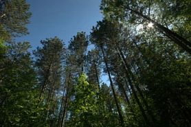 Photo by Josh Mayer
Tar Dam Pines features several stands of oak and pine-oak woodland, most with white oak as a common canopy species. Other canopy trees include red oak, sugar maple, paper birch, and white pine. An interesting and unique area occurs to the west where the canopy becomes scattered and the habitat is dominated by a ground layer of bracken fern and early low blueberry. It is unclear whether this community type is an artifact of past harvest or is evidence of a prior savanna/woodland or bracken grassland community.
Original land survey records mention there being "sparsely timbered land" in this area. Scattered rocks and boulders occur within the complex and support common polypody while areas of exposed bedrock contain species such as Cladonia and pale corydalis. Along the east end of the site is a black ash-dominated swamp. Similar lowland black ash swamps occur throughout the complex along intermittent creeks. Together these lowland areas form the headwaters of the drainage leading to Waupee Creek. Other notable species include the Indian cucumber root (Medeola virginiana). Tar Dam Pines is owned by the US Forest Service and was designated a State Natural Area in 2007.
Very few State Natural Areas have public facilities, but nearly all are open for a variety of recreational activities as indicated below. Generally, there are no picnic areas, restrooms, or other developments. Parking lots or designated parking areas are noted on individual SNA pages and maps. If a developed trail is present, it will normally be noted on the SNA map and/or under the Maps tab. A compass and topographic map or a GPS unit are useful tools for exploring larger, isolated SNAs.
The good majority of SNAs are isolated and have few or no facilities. Some SNAs have vehicle access lanes or parking lots, but their accessibility may vary depending on weather conditions. Parking lots and lanes are not plowed during winter. Hiking trails may be nonexistent or consist of undeveloped footpaths. A GPS unit or compass and a detailed topographic map are useful tools for exploring larger SNAs.
Non-DNR lands
Entrance fees: For non-DNR-owned SNAs, we are unaware of any vehicle or admission fees. However, please contact the landowner for more information.
Hunting and trapping
Other activities
Other allowable activities such as - but not limited to camping, geocaching and bicycling are determined by the landowner. Please contact them directly or visit their websites for details.
Location
Within the Chequamegon-Nicolet National Forest. Oconto County. T32N-R17E, Sections 9, 10, 15, 16. 847 acres.
Driving directions
The site is located approximately 3 miles south and 8 miles east of Lakewood. The site is accessible from Forest Roads 2104 and 2324. From Lakewood, go south on Highway 32 for 4.5 miles, then east on Tar Dam Road for 7.3 miles to a 90-degree turn in the road. Park and walk east into the site.
The DNR's state natural areas program comprises lands owned by the state, private conservation organizations, municipalities, other governmental agencies, educational institutions and private individuals. While the majority of SNAs are open to the public, access may vary according to individual ownership policies. Public use restrictions may apply due to public safety, or to protect endangered or threatened species or unique natural features. Lands may be temporarily closed due to specific management activities. Users are encouraged to contact the landowner for more specific details.
The data shown on these maps have been obtained from various sources, and are of varying age, reliability, and resolution. The data may contain errors or omissions and should not be interpreted as a legal representation of legal ownership boundaries.
To create your custom map where you can zoom to a specific location, please use the DNR's mapping application.
Tar Dam Pines is owned by: U.S. Forest Service