Swan Lake Sedge Meadow and Barrens
No. 665
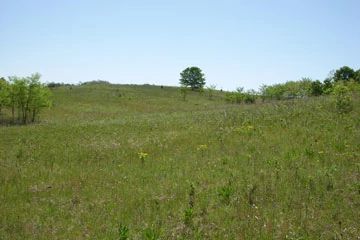
Photo by Jeff Lorch
Swan Lake Sedge Meadow and Barrens feature an upland island and peninsula supporting oak barrens, savanna, and prairie remnants surrounded by a high-quality sedge meadow with fen components. Black oak dominates the barrens at the north end of the site with white oak and red maple present in smaller numbers. The understory is dominated by Pennsylvania sedge and bracken fern. Characteristic forbs include bird's-foot violet, wild columbine, frostweed, prairie alumroot, bastard toadflax, prairie phlox, wood betony, Cynthia and common spiderwort.
Hazelnuts and early low blueberries are abundant in the shrub layer. Several openings are present on the island and represent former agricultural fields and homesteads. Areas of sand prairie are present and contain such species as switchgrass, little bluestem, June grass, sedges, arrow-leaved violet, lyre-leaved rock cress, hoary puccoon and blue-eyed grass. At the south end of the site, oak barrens are also present along with oak openings and small areas of dry prairie. The terrain here has numerous esker-like ridges with wet swales. Bur oak is present along with the cylindrical blazing star, whorled milkweed, leadplant, side-oats grama, silky aster, prairie dropseed, Kalm's brome and needle grass. Swan Lake Sedge Meadow and Barrens is owned by the DNR and was designated a State Natural Area in 2012.
Very few State Natural Areas have public facilities, but nearly all are open for a variety of recreational activities as indicated below. Generally, there are no picnic areas, restrooms, or other developments. Parking lots or designated parking areas are noted on individual SNA pages and maps. If a developed trail is present, it will normally be noted on the SNA map and/or under the Maps tab. A compass and topographic map or a GPS unit are useful tools for exploring larger, isolated SNAs.
The good majority of SNAs are isolated and have few or no facilities. Some SNAs have vehicle access lanes or parking lots, but their accessibility may vary depending on weather conditions. Parking lots and lanes are not plowed during winter. Hiking trails may be nonexistent or consist of undeveloped footpaths. A GPS unit or compass and a detailed topographic map are useful tools for exploring larger SNAs.
Entrance fees: Except for Parfrey's Glen, the Cambrian Outlook in the Dells of the Wisconsin River, SNAs within State Parks and some within State Forests, all other DNR-owned SNAs do not have any admission fees. For more information, see Wis. Admin. Code NR 45 [exit DNR]. For non-DNR-owned SNAs, we are unaware of any vehicle or admission fees. However, please contact the landowner for more information.
Allowable activities: DNR-owned land
The activities listed below are generally allowed on all DNR-owned SNA lands. Exceptions to this list of public uses, such as SNAs closed to hunting, are noted above and posted with signs on the property site.
- Hiking
- Fishing
- Cross country skiing
- Hunting
- Trapping
- Scientific research (permit required [PDF])
- Outdoor education
- Wild edibles (What is this?)
- Pets (Rules)
- Wildlife viewing
Prohibited activities: all SNAs
Although a handful of sites allow activities like primitive camping (e.g. Lower Chippewa River on sand bars) or horseback riding (e.g. S. Kettle Moraine), the activities listed below are generally prohibited on DNR-owned SNAs.
- Camping and campfires
- Collecting of animals (other than legally harvested species), non-edible fungi, rocks, minerals, fossils, archaeological artifacts, soil, downed wood, or any other natural material, alive or dead.
- Collecting for scientific research requires a permit issued by the DNR
- Collecting of plants including seeds, roots or other non-edible parts of herbaceous plants such as wildflowers or grasses
- Drones: Flying-related activities, including the use of drones, hang-gliders and model airplanes, are prohibited. Permission may be issued by the SNA Program for the use of drones for educational or research purposes
- Geocaching
- Horseback riding
- Rock climbing
- Vehicles, including bicycles, ATVs, aircraft, and snowmobiles except on trails and roadways designated for their use.
For rules governing state-owned SNAs and other state lands, please consult Chapter NR 45 Wis. Admin. Code [exit DNR].
Location
Within Swan Lake Wildlife Area, Columbia County. T12N-R9E, Sections 10, 11, 15. 702 acres.
Driving directions
From the intersection of US Highway 51 and State Highway 16 in Portage, go south on 51 for 2.6 miles, then east on County P for 0.6 miles to a DNR parking area north of the road.
The DNR's state natural areas program is comprised of lands owned by the state, private conservation organizations, municipalities, other governmental agencies, educational institutions and private individuals. While the majority of SNAs are open to the public, access may vary according to individual ownership policies. Public use restrictions may apply due to public safety, or to protect endangered or threatened species or unique natural features. Lands may be temporarily closed due to specific management activities.
Users are encouraged to contact the landowner for more specific details. The data shown on these maps have been obtained from various sources, and are of varying age, reliability, and resolution. The data may contain errors or omissions and should not be interpreted as a legal representation of legal ownership boundaries. To create your custom map where you can zoom to a specific location, please use the DNR's Mapping Application.
Swan Lake Sedge Meadow and Barrens is owned by: Wisconsin DNR